Viewing entries tagged
hydroplate theory

Share

Missing dirt from the Grand Canyon found on the floor of the Gulf of California!


The Grand Canyon is often included on lists of the "Seven Wonders of the Natural World" (following on the tradition of creating lists of the "Seven Wonders of the World," a tradition which started in antiquity).  It is truly one of the most massive canyons on earth, stretching well over 200 miles, over the course of which its widths span from four to an incredible eighteen miles across, and reaching an average depth of a mile from the rim to the riverbed far below.

The amount of earth that had to be removed to form such an enormous abyss is truly staggering.  The US National Park Service web page lists the volume of the Grand Canyon as 5.45 trillion cubic yards.  This is an almost-inconceivable volume of dirt that had to be removed.  

Where did it all go?

Walt Brown, the originator of the hydroplate theory, who devotes an entire chapter of his book (available online and in print) to the Grand Canyon, recognizes the significance of this question.  He notes that the volume of sediments that had to be displaced totals about 800 cubic miles!  

He also explains that most conventional theories for the formation of the Grand Canyon, such as the idea that the Colorado River slowly eroded this massive canyon (averaging ten miles wide and one mile deep for well over 200 miles) have a real problem explaining where all that dirt went.

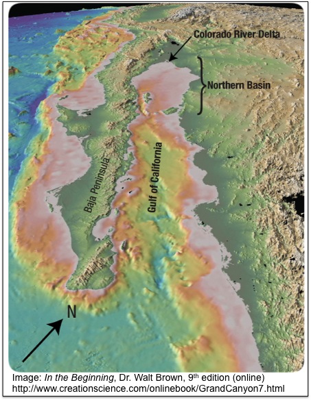
The Colorado River empties into the Gulf of California (the body of water between the Baja peninsula), and Mexico itself.  If that dirt was gradually eroded, there should be a massive delta where the river meets the gulf, but the delta there is tiny, containing not even 1% of the volume of dirt that must at one time have been removed from the Grand Canyon (see for instance point 20 on this web page from Dr. Brown's book).

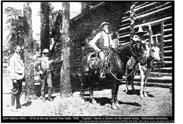
Dr. Brown relates the story of one of the Grand Canyon's most colorful characters from the end of the nineteenth and early twentieth centuries, John Hance (known as "Captain" John Hance, or sometimes "Cap").  He became famous for regaling visitors with his tall tales, including his explanation of how the mighty canyon came into being.  Quoting a description of Captain Hance's famous account of the canyon's origin, given by former Arizona governor and former US Secretary of the Interior Bruce Babbitt, Dr. Brown relates:
Children loved John Hance, and to them he always explained how the canyon came into being.  "I dug it," he would say simply.  This story worked well for years until one little four-year old girl asked seriously, "And where did you put all the dirt?"  Hance had no ready answer; he never used that story again.  But it bothered him the rest of his life, and when he was dying he whispered to his waiting friends, "Where do you suppose I could have put that dirt?" (from this page in Dr. Brown's online book, quoting Bruce Babbitt -- see footnote 4. on this page).
For more of John Hance's deadpan tall-tales, see this description of the colorful Grand Canyon guide.  Apparently, the question of where all that dirt went made a deep impression on Captain Hance, and troubled him to the end of his days.  It is a question that conventional geologists have yet to answer.

However, the hydroplate theory of Dr. Brown provides an answer for the question of where all those cubic miles of dirt ended up.  As related in previous posts, and discussed in greater detail in his book, Dr. Brown's hydroplate theory argues that the Grand Canyon was not carved by the mechanism of slow erosion by the Colorado River over millions of years, but rather that it was created in a relatively short period of weeks or months by the catastrophic breaching of two enormous inland seas, each one of which were left over from a world-wide flood.  Previous posts pointing to evidence that makes the conventional theory difficult to accept but which support Walt Brown's theory for the formation of the Grand Canyon include:
If the Grand Canyon is a product of a massive, high-volume and high-intensity outpouring of millions of tons of water from two huge inland seas left over from the world-wide flood (you can see where Dr. Brown believes these two huge water bodies once stood on this map in his online book), then the final resting place for all that dirt would be very different than if the dirt were removed gradually over millions of years by a relatively small river.

In fact, the sudden breaching of two enormous water bodies of the size described by the hyrdoplate theory would have removed even more dirt than was in the Grand Canyon, as massive as that is.  According to the hydroplate theory, the breaching of these two inland seas removed at least 2,000 cubic miles of sediments above what is now the Grand Canyon, in addition to the 800 cubic miles of sediment that had to come out of the canyon itself.  You can read in his book how the removal of all that sediment caused the layers below to arch upwards, a phenomenon whose evidence is clearly visible in the geology of the region of the Grand Canyon, and in places to crack (Marble Canyon was caused by this upward arching and subsequent cracking motion).

All those cubic miles of sediments were washed away by the violent release of the two huge lakes, and they swept along until they dumped into the sea -- in this case, they dumped into the Gulf of California, where the Colorado River still meets the sea today.  Along the way, many sediments were deposited into the region between the Grand Canyon and the Gulf of California, but a huge quantity of them dumped into the gulf and they are still there today.

The image below, from Dr. Brown's book here (see section 13, "Missing Dirt"), contains modern three-dimensional imagery of the Gulf of California showing where all those sediments ended up.  Dr. Brown's caption for the image reads in part as follows:
Here's the Dirt.  It's right where we would expect it, if we understood the Grand Canyon's rapid and violent formation.  Hidden beneath the flat floor of the Gulf of California are at least 6,000 cubic miles of sediments.  That basin, bounded on the south by the largest islands in the Gulf, has an area of 15,000 square miles (220 miles long and 60-100 miles wide).  Sediment depths are up to 1.2 miles thick!  About half the basin's sediments were rapidly transported from the Grand Canyon (on the figure's northern horizon), along the path now occupied by the Colorado River.
Why is the Northern Basin's 15,000-square-mile floor so flat?  Within weeks, a few thousand cubic miles of sediments were swept into the basin.  The larger particles settled out first, near today's shoreline.  Finer particles settled out last, but until they did, the muddy water, because it was denser, flowed to the basin's deeper regions where the mud eventually settled, flattening the seafloor.
You can see water depths for the various parts of the Gulf of California in this 1956 study of the feature, "Oceanographic and Meteorological Aspects of the Gulf of California," by Gunnar I. Roden.  The excellent bathymetry charts on pages 22 and 23 of that study clearly show that while the northern portion of the gulf (where Dr. Brown's theory says the sediments were dumped) has depths below 200 meters, the rest of the gulf reaches depths of over 2,800 meters!  In other words, if Dr. Brown is correct -- and the evidence from the Gulf of California seems to support his argument -- then the depths of those sediments are truly astonishing.

This evidence is just one more of many pieces of evidence surrounding the formation of the Grand Canyon which appears to refute the conventional explanations and support the explanation put forward in Dr. Brown's hydroplate theory.  The evidence for the hydroplane theory from the Grand Canyon alone is extremely compelling, but that is just one geological feature among literally several hundred more that Dr. Brown examines in his book, all of which contain evidence which appears to support his theory.

Based on all this evidence, the conventional theories seem about as plausible as Captain John Hance's wry explanation for the origin of the Grand Canyon.  Or, to say it another way, Captain Hance's explanation appears just as good as the stories that park rangers tell visitors to this day regarding the origin of this "natural wonder of the world."  (But where did he put all that dirt?)


Share

Share

New study on human-induced seismic activity due to fracking wastewater injection


A brand-new study published in the journal Science entitled "Injection-Induced Earthquakes" by William Ellsworth of the US Geological Survey's Earthquake Science Center in California has concluded that deep wastewater injection wells may have played a role in the increase of earthquakes in the central US during the years 2011 and 2012.

The high volumes of wastewater being injected deep underground in these disposal wells are a by-product of the process of hydraulic fracturing, or "fracking."  While the injection of this wastewater had previously been suspected as a possible cause of human-induced seismic activity, no study had yet concluded with a high degree of certainty that this injection was actually causing the increased seismic activity.  The newly-published study concludes that there is a connection between the injection of large volumes of wastewater from fracking and the increase of seismic activity, including earthquakes measuring over 3.0.

The study includes a graph showing the cumulative count of earthquakes with magnitudes of 3.0 or greater in the US "midcontinent."  The cumulative count increases steadily from 1970 through 2000 and then jumps in 2001 and increases at a more rapid pace from 2001 to the present -- an increased rate that coincides with the advent of aggressive hydraulic fracturing in the mid-continental US.


The study concludes that the fracking itself, long known to induce minor earthquakes that usually measure below 3.0, is not the probable cause of the increased number of magnitude 3.0+ earthquakes, but the practice of injecting wastewater from fracking operations into deep disposal wells is probably a contributing factor.  A quotation from the structured abstract of the study explains:

More than 100,000 wells have been subjected to fracking in recent years, and the largest induced earthquake was magnitude 3.6, which is too small to pose a serious risk. Yet, wastewater disposal by injection into deep wells poses a higher risk, because this practice can induce larger earthquakes. For example, several of the largest earthquakes in the U.S. midcontinent in 2011 and 2012 may have been triggered by nearby disposal wells. The largest of these was a magnitude 5.6 event in central Oklahoma that destroyed 14 homes and injured two people. The mechanism responsible for inducing these events appears to be the well-understood process of weakening a preexisting fault by elevating the fluid pressure. However, only a small fraction of the more than 30,000 wastewater disposal wells appears to be problematic—typically those that dispose of very large volumes of water and/or communicate pressure perturbations directly into basement faults. 
Again, although this connection had been suspected previously, it had not been studied enough for scientists in the US government to conclusively admit to a connection.  In fact, this statement from the Secretary of the US Department of the Interior (which includes the USGS) published on 04/11/2012 concludes by saying in the penultimate paragraph: "Although we cannot eliminate the possibility, there have been no conclusive examples linking wastewater injection activity to triggering of large, major earthquakes even when located near a known fault."  We can assume that the Department of the Interior will issue a new statement now that further study has demonstrated more evidence of a conclusive connection.

The process by which the injection of wastewater into the ground can trigger earthquakes is illustrated in the video above, as well as in the animated gif at the bottom of this article in Mother Jones magazine discussing the newly-published study.

The process is also discussed in some detail in a blog post that was published here on 04/11/2012 (the same date as the date of publication for the Department of the Interior statement referenced above).  The reason that post was published on the same day that the Department of the Interior chose to release a statement is the fact that at that time Bill Ellsworth, the author of this most-recent study, was beginning to suggest that the rise in seismic activity shown in the graph above may have been connected to the process of wastewater injection.  The blog post explains that this conclusion is perfectly aligned with the hydroplate theory of Dr. Walt Brown, and that Dr. Brown has in fact long predicted that the injection of water deep underground could trigger earthquakes (see for instance note 69 on this page of his book's online version -- published physical versions of his book have contained similar warnings for years prior to 2011).

As that post also explains, the presence and direction of the numerous faults found all over the earth, including in the middle of plates, is not well explained by the existing tectonic theory but is explained by the hydroplate theory.  He notes that the faults and fracture zones on the earth (including on the floor of the Atlantic Ocean) do not conform to the explanation that they were caused over millions of years by tectonic movement, because they are sometimes many degrees out of parallel, sometimes curved, and sometimes even intersect one another (see for example his discussion on this page).

The hydroplate theory proposes that faults and fracture zones were the result of the tremendous mass imbalances in the earth during the events surrounding a global flood, which included the dramatic rise of the basement mantle under what is today the Atlantic Ocean when the escaping water eroded overlying crust and removed the weight of that crust, followed by an even more dramatic collapse of the area that now form the basin of the Pacific Ocean and Indian Ocean, as mass moved towards the Atlantic, accompanied by tremendous friction, melting, and magma production.  Thus, the very faults themselves which are discussed in this most-recent study of the possible connection between wastewater injection and earthquakes are important pieces of geological evidence which support the hydroplate theory's explanation of earth's geology.

Note that the connection between earthquakes and wastewater injection does not mean that all earthquakes in the center of plates, far from plate boundaries, are the product of human-induced activity.  Numerous previous posts have discussed the reasons that earthquakes can take place far from plate boundaries -- a phenomenon that the hydroplate theory explains quite satisfactorily, but one that the tectonic theory has some difficulty with.  Powerful earthquakes far from plate boundaries have been reported in previous centuries (such as the powerful New Madrid earthquake in Missouri in 1811), when no fracking was taking place, and earthquakes have been measured far from plate boundaries in the middle of Antarctica where no fracking operations are being conducted (as far as we know).

The editor's summary of this most-recent study also notes that the deep fluid injection of wastewater near faults may trigger earthquakes when powerful seismic waves from far-off earthquakes reach the faults in question.  Unfortunately, the hydroplate theory's explanation of earthquakes appears to support the likelihood that the number of such earthquakes may increase in the future.  This possibility is discussed at the end of this previous post which goes into more detail on the mechanisms that cause "deep earthquakes."

The study of earthquakes is very important, and the hydroplate theory's explanation of the cause of faults and earthquakes appears in many ways to be superior to the conventional tectonic models that most scientists are using today as the foundation for their understanding of these phenomena.  This most-recent study appears to be yet another example of research that confirms assertions that Dr. Walt Brown has been making for years based on his hydroplate theory.

Share

Share

Pacific volcanoes and the problems with the plate tectonic theory


Above is a diagram of the conventional tectonic view of "subduction" -- the action of one plate supposedly diving beneath another plate.  This diagram can be found on Wikimedia commons, and there are many more like it which all show roughly the same concept.

According to the conventional view, when one plate runs into another, it will sometimes dive beneath the other plate, creating a trench (marked in the diagram above) along the line of subduction.  Additionally, the conventional theory asserts that the diving or subducting plate is subjected to intense heat and pressure, which often causes it to melt as it dives deeper and deeper, turning into magma which then works its way towards the surface and creates a chain of volcanoes (these are also shown in the diagram above). 

Note that these volcanoes, according to the conventional theory, should be located on the side of the trench belonging to the plate that is not diving.  The magma is coming up from the melting of the front edge of the subducting plate, which is now underneath the non-diving plate (the edge of the diving plate is now on the far side of the trench from its plate, and as it melts its magma bubbles upward on the side of the non-diving plate).  

In other words, in the diagram above, we see a subducting plate coming from the left, and a non-diving plate on the right.  The volcanoes should form on the right of the trench, in the plate on the right, but they are the product of the front edge of the plate coming from the left.  The front edge of the left plate, which is subducting and is now under the right plate, creates the magma that forms the volcanoes.

Below is another diagram showing almost the same process, but this time instead of taking place near a coast, it is taking place at sea and the volcanoes are forming on the ocean floor instead of on the continent.


Again, this diagram comes from Wikimedia commons, and again there are many other variations on this diagram that one can find on the internet, all illustrating the same general concept.  

Most people learn these fundamentals of the conventional plate tectonic theory in school, and the explanation sounds fairly reasonable.  However, there are many reasons to challenge this basic explanation for the formation of ocean trenches, and to question the very existence of such a process as "subduction."  

Dr. Walt Brown, the originator of the hydroplate theory, has challenged this conventional explanation and provided numerous examples of evidence which argues against this explanation.  He discusses these reasons in depth, along with his alternative explanation for the evidence, in this chapter of his book on the hydroplate theory, which is available online in its entirety (and available for purchase from Dr. Brown and other book-sale channels).  In fact, he lists seventeen reasons that subduction is an extremely questionable explanation for the evidence that we actually find in the deep oceans, where most of the supposed subduction zones are located on our planet.

Some of the problems with the subduction theory of tectonics have been addressed in previous blog posts, such as this one, this one and this one.  Another problem with the tectonic explanation that has not been addressed directly on this blog before is the existence of volcanoes on the Pacific floor that do not appear to fit the theory -- or the diagrams above -- at all.

As Dr. Brown writes in his book, 
On the western Pacific floor are 40,000 volcanoes taller than 1 kilometer.  They lie among trenches, not on only one side of trenches. [. . .]  If subducting plates generate magma that forms volcanoes, then volcanoes should lie on the side of the trench above the descending plate.  [See Figure 85 on page 150].  Actually, most volcanoes in the western Pacific lie on the opposite side of trenches.  Also most volcanoes in the western Pacific are interior to a plate -- contradicting plate tectonics, which says volcanoes should usually form near plate boundaries.  
The above quotation comes from pages 154-155 of his 8th edition, and can also be found online about a third of the way down this webpage, under the heading "Scattered volcanoes."

Below is an image from Google maps showing the southwestern area of the Pacific ocean floor.  You can see for yourself the volcanoes which Dr. Brown is discussing in the quotation above, and consider whether the plate tectonic explanation is a good one for the evidence that we actually find, and whether the reality looks anything like the subduction diagrams shown above:


In the map, you can clearly see trenches toward the west (left) side of the image -- some of the deepest ocean trenches on our planet, in fact.  The conventional view is that the plate to the right is subducting under the plate to the left to create these trenches, although how it makes those arcs and cusps is another huge problem with the tectonic theory.  However, more to the point of the volcano-location discussion, notice all the volcanoes scattered across the floor of the Pacific to the right of the trenches, some of them extremely far away from any supposed "subducting" activity.  The Hawaiian Island chain is one series of volcanoes in the image, but there are many others that you can see, none of which look like they support the subduction description of events at all.

Dr. Brown believes that the magma that created these volcanoes does not come from a subducting plate -- the magma came from the catastrophic events surrounding a past global flood on our planet.  According to his theory, the entire floor of the Pacific was pulled towards the center of the earth by the physics involved in the flood event.  When this happened, the intense shearing and heat generated magma around the entire edge of the subsidence -- a ring of magma known today as the "Ring of Fire."  The same forces also "depressed, cracked, and distorted the entire western Pacific.  Frictional melting produced large volumes of magma that spilled out on top of the Pacific plate.  Some of that magma formed volcanoes" (154).

This explanation does a much better job of accounting for all the evidence that we actually find in the Pacific.  The tectonic theory, while better than what came before it, has enormous problems.  The "subduction" explanation is one major problem with the tectonic theory, but it is not alone.  Scientists should overcome their aversion to "catastrophic" explanations and consider the hydroplate theory of Dr. Walt Brown, which provides very comprehensive and satisfactory explanations for the evidence we find on our amazing planet Earth.

Share

Share

Immature dinosaur fossil from the Alaskan Arctic further evidence for earth's "Big Roll"


Another special thank-you goes out to Mr. TRB of California, who noticed this story entitled "Juvenile Dinosaur Found in Alaskan Arctic" and immediately realized the importance of such a find to the subjects regularly discussed on this blog.

The article reports the recent discovery of a skull believed to belong to an immature pachyrhinosaurus, a plant-eating dinosaur of the Ceratopsidae family of horn-shaped dinosaurs (other members of this family include Styracosaurus, Monoclonius, and the famous Triceratops).

The full research article about the find was published on June 19th of this year in the journal PLOS One, and is entitled "An Immature Pachyrhinosaurus perotorum (Dinosauria: Ceratopsidae) Nasal Reveals Unexpected Complexity of Craniofacial Ontogeny and Integument in Pachyrhinosaurus," by Anthony R. Fiorillo and Ronald S. Tykoski. 

As shown in the map above, the fossil discussed was discovered well north of the Arctic Circle, in northern Alaska south of Prudhoe Bay, in the vicinity of the Kikak-Tegoseak Dinosaur Quarry.  Numerous other fossils have been found in this same quarry in the past -- including a tyrannosaur, other pachyrhinosaurs, and even insects, according to this list from the Smithsonian's ETE (evolution of terrestrial ecosystems) paleobiology website.

The discovery of so many dinosaur fossils in a quarry so far north of the Arctic circle is remarkable in and of itself, and raises questions as to how they found food to sustain their massive bulk so far to the north, especially the plant-eaters such as Pachyrhinosaurus.  Scientists generally believed that dinosaurs ranging so far were probably migratory adults, who would head back south during the long, cold, Arctic winter (above the Arctic circle, there are days during the winter in which the sun never emerges above the horizon). However, this newly-discovered skull of a young Pachyrhinosaurus in the same formation appears to upend that theory, causing scientists to conclude that the dinosaurs perhaps lived there year-round, and even had offspring there.

Here is a description of the region from the original research article announcing and discussing the find:
The Kikak-Tegoseak Quarry is a monodominant bonebed deposit [13] with a minimum of eleven individuals represented in the quarry, based upon the number of occipital condyles currently known from the site (including that in the nearly complete skull DMNH 22558). The specimen was collected as a float block found within a meter of the main Kikak-Tegoseak Quarry edge. We are confident that the new specimen can be referred to P. perotorum and that it does not represent a second ceratopsid taxon from the site. The specimen is notable because it comes from a smaller, relatively immature individual, contrary to previous published statements about the individuals from the quarry all being of similar ‘adult’ ontogenetic stage [13] and therefore expands the known age profile of this taxon from the site.
As discussed in previous posts, the discovery of any fossils at all, anywhere on the planet, should raise questions as to how those bones were preserved and petrified, because under normal conditions the bones of animals that die in the wild are decomposed by microbes and other factors long before they can turn to stone.  Special conditions, such as rapid burial under thick mud, are probably required for the creation of most fossils.  The fact that there are so many fossils around the world points to the possibility of some sort of cataclysm or cataclysms that created such special conditions in the ancient past.  

Further, this fossil bed contains numerous fossils of the same species, as well as of a few other species, as mentioned in the article and in the list of taxa linked previously.  Could this concentration of fossils represent numerous individuals who fell victim to a single catastrophic event?  

Finally, the fact that these fossils are found so far to the north -- and include the remains of an immature Pachyrhinosaurus -- is perhaps the most puzzling aspect of all.  Are we really to believe that these were all representatives of a species of "polar dinosaur," who spent their year at such extreme northern latitudes, near the northern coast of Alaska, and even bore their young there?  These are reptiles, not warm-blooded caribou.

All of the difficult problems listed above, however, are explained by the hydroplate theory of Dr. Walt Brown.  That theory proposes that there is substantial evidence to support the possibility that a catastrophic world-wide flood once erupted with great violence and covered the earth, accompanied by massive amounts of sediments which would have rapidly buried and fossilized many animals and plants.  

Even more importantly for the understanding of how so many seemingly incongruous fossils are found at latitudes so far to the north (and so far to the south as well), Dr. Brown's theory discusses why the principles of physics would have caused the entire earth to undergo a "Big Roll" in the aftermath of that flood event, a roll which would have brought latitudes that were formerly further south "up" towards the Arctic, as well as (on the other side of the earth) latitudes that were formerly in more temperate climates "down" into the Antarctic as well.  

You can envision this event by taking a basketball between two hands and looking down at it, imagining that the point on the ball that you are looking down on represents the north pole, and then rotating the ball forwards using the rotation of both of your wrists -- bringing "latitudes" on the ball that were formerly further south up into the "north pole" area that you are looking at from above.  Acknowledgement goes out to Rand Flem-Ath for this basketball metaphor, which he used in an interview in 2009 (for the record, this mention is not intended to suggest that Mr. Flem-Ath supports the hydroplate theory; he appears to believe something different, although he also believes that the conventional theories generally taught as undisputed fact have serious problems and probably are not correct).

Of course, when you rolled that basketball, you moved a lot of fossils that had been buried at more temperate latitudes on the ball up towards the "Arctic" part of the ball, and on the other side you rolled fossils from more temperate latitudes down towards the "Antarctic" part of the ball.  So, those animals did not need to actually live in those latitudes before they were buried and before the earth experienced its "Big Roll."  According to Dr. Brown's theory, events that took place after the rapid burial of plants and animals led to the physics that caused the roll of the earth.

Previous posts have discussed the many fossil findings which have surfaced over the years in both the Arctic and the Antarctic that support the idea of a "Big Roll."  These include:
This discovery of the immature Pachyrhinosaurus would appear to join this list of evidence pointing to the earth's Big Roll at some point in the ancient past (and there are other pieces of evidence, not found in the Arctic or Antarctic, which also support the Big Roll conclusion).

More evidence for Dr. Brown's theory continues to show up around the world.

Share

Share

The geology of the Little Colorado River Gorge


Over the weekend, on Sunday 06/23, aerialist Nik Wallenda crossed the Little Colorado River Gorge on a two-inch-wide steel cable, taking approximately 22 minutes to make the journey.

Many watched the event live on the Discovery Channel, which sponsored the c
rossing.  Some of the footage can be seen here at the Discovery Channel website.

Some Native tribes protested the event, arguing that the canyon is sacred to their people and should not be used for a publicity stunt.  Others assisted in the event, and the Navajo Nation provided the permit in exchange for the clean up of some platforms and cables left behind for decades after a planned crossing in the 1970s that never took place due to lack of funding (according to this article).

Whatever your opinion of that controversy, Wallenda successfully accomplished the incredible crossing over the 1,500-foot chasm.  The geology of the location is absolutely breathtaking.  It also provides important clues about our planet's past.

Below is a map showing the location of the Little Colorado River Gorge.  It empties into an area of unusual erosion called Nankoweap Canyon, near the point where it comes together with the Colorado River.  This junction of the the Colorado and Little Colorado is called the Confluence and is sacred to the Native tribes of the area as the site of the most ancient inhabitants of the region.


Both Nankoweap Canyon and the Little Colorado River Gorge are important clues to the mystery of the formation of the Grand Canyon, and they present geological evidence that confounds conventional theories.

Dr. Walt Brown, the originator of the hydroplate theory, believes the Grand Canyon was formed by events that took place in the aftermath of a global flood, and his theory provides an explanation for the Little Colorado River and Nankoweap Canyon (as well as for the very difficult-to-explain turn in the Colorado River seen in the map above, where the river that was running generally north-to-south takes a hard right turn to the west and plows right through the enormous massif of the Kaibab Plateau, which is colored green in the map).

Previous posts have detailed Dr. Brown's theory for the creation of the Grand Canyon -- see for example:
n and surrounds, see for example:
Dr. Brown believes that the mechanisms that formed the Grand Canyon and surrounding features began with two large bodies of water that were trapped after the floodwaters drained off the earth, and uplifted by the physics related to the rapid formation of the Rocky Mountains, whose weight caused them to sink downwards, forcing the Colorado Plateau upwards.  

Dr. Brown calls these two lakes "Grand Lake" (further north) and "Hopi Lake" (further south), and diagrams where they were on this map. He believes that Grand Lake eventually breached catastrophically due to increased rainfall and runoff after the flood (caused by warmer oceans). The tons of water cascading out of it eventually undermined the walls holding in Hopi Lake as well, and it breached as well.  The Little Colorado River Gorge marks the location of the breach of Hopi Lake.

About halfway down this webpage, Dr. Brown discusses Nankoweap Canyon and the evidence there which is very difficult to explain by proponents of the conventional theory for the Grand Canyon's formation.  Discussing the detailed image of the Nankoweap Canyon region shown there, he writes:
Nankoweap—Region of Unusual Erosion. This view is looking southeast from 4,400 feet above the ground. The Little Colorado River enters the southern end of Marble Canyon at the top center. The yellow line encloses a region of unusual erosion. Notice that on the top of the high Kaibab Plateau, streams do not flow into the many canyons that are cut into this southeastern portion of the Kaibab Plateau. So, what cut these side canyons, and why are they in such a localized area? Why would the terrain east of Marble Canyon, which is at least 2,000 feet below the top of the Kaibab Plateau and most of this erosion, be so smooth? On top of Nankoweap Mesa are slumps, landslides, and rockfalls. How can rocks fall and mud flow onto the top of a mesa?  
Another point of difficulty for conventional theorists is the origin of the Little Colorado Gorge in the first place.  As you can see from the map above, it seems to spring from out of the desert itself.  Dr. Brown's theory argues that subsurface water burst out of the water table after Grand Lake and Hopi Lake began to empty, and it was this subsurface water which was responsible for creating many of the major canyons that we see emptying into the Grand Canyon from the sides.  The canyons themselves, such as Marble Canyon and the Little River Gorge, are cracks created when the ground arched upwards after the catastrophic breaching of Grand Lake and Hopi Lake removed the material above.  The subsurface water then flowed out the sides of these cracks, creating the side canyons we see today, including the Little Colorado Gorge.

The fact that Nankoweap Canyon was the site of the earliest known habitation in the area is also problematic for conventional geological theories, because they have a hard time explaining where all the water came from that attracted the Old Ones or Anasazi to the area in the first place, and what caused it to disappear, causing them to leave.  This article by Terry Hurlbut discusses this question, and interestingly enough does so in light of Dr. Brown's theory, which provides a satisfactory explanation for the human history of the area.

We can all be glad that Nik Wallenda made it safely across the canyon on his first try.  His feat should cause us to examine the amazing geology of the Little Colorado River Gorge and the Grand Canyon, as well as to reflect upon the sacred traditions of the Native tribes who still remember and honor their ancestors who lived in the region so long ago -- and to consider the ways in which the geology and the human history of this beautiful area are intertwined. 


Share

Share

Comet Tempel 1 and the Deep Impact mission of 2005


(image above: Wikimedia commons).

Comet Tempel 1 is a short-period comet with an orbital period of approximately 5.5 years and a perihelion of about 1.5 AUs (an AU or "astronomical unit" is a unit that is roughly the mean earth-sun distance, and the perihelion of 1.5 AUs means that Comet Tempel 1's orbit takes it further from the sun than the orbit of Mars but not as far as Jupiter).  

The comet was discovered in April of 1867 by Ernst Wilhelm Leberecht Tempel, of France, who was looking for comets at the time (see this discussion of the comet's history from the NASA webpage). As that page explains, the comet was observed that year using telescopes until it was lost from sight in August of 1867, but it was reacquired at its next visit in 1873, then again in 1879 (when Tempel himself recovered visual observation of his discovery), after which it was lost to observers on earth until 1967.

In 1967, Professor Elizabeth Roemer, an American astronomer, took several photographic images of the area in space where the comet was predicted to reappear.  Her initial inspection of the plates turned up nothing, but upon re-checking them the following year she noticed a very faint (18th magnitude) object near the location that the comet's return had been calculated to be, in the plate from June 8th of 1967.  Later analysis of the comet confirmed that this image was indeed Comet Tempel 1, reacquired after all those years.

On its next visit in 1972, Professor Roemer and another astronomer successfully recovered observation of Comet Tempel 1, and it has since been observed on every subsequent visit, according to the NASA site linked above.  

The most remarkable history of the comet, however, was yet to take place.  In 1999, planning began for a mission to study the composition of comets by firing a "smart impactor" into a comet, releasing material from the comet into space from the impact.  This material could then be observed up close by the spacecraft that had fired the impactor, and the spectrometry and other data studied to reveal information about the makeup of the comet itself.

The mission was dubbed "Deep Impact," and the Deep Impact spacecraft was launched from Cape Canaveral Air Force Station (Cape Kennedy) in January of 2005, on its way to a rendezvous with Comet Tempel 1 in July of the same year (see this NASA page for details of the launch).  The Deep Impact spacecraft was a two-part system consisting of the flyby spacecraft (described as being about 11 feet by 8 feet by 7 feet) and the smart, instrumented, self-guiding impactor (which weighed about 816 pounds counting fuel at the time it was launched).  The impactor was made largely of copper (it was 49% copper) to minimize interference with the comet's material.

At this time eight years ago, Deep Impact was speeding towards Tempel 1, taking images as it approached.  From the images, scientists have calculated that the comet's nucleus is roughly 7.6 kilometers (4.7 miles) by 4.9 kilometers (3.0 miles), and venting or outgassing sporadically as it orbits the sun.  At twenty-four hours before intended impact, the impactor separated from the flyby vehicle and shot towards the comet's nucleus.

What happened next is astonishing.  The impactor successfully struck the comet and created an enormous cloud of debris (often referred to as the "ejecta" by scientists writing about the event).  The spectral analysis revealed a host of amazing material from the comet, including organic material!  How did that get there!?

In addition to this perplexing discovery, scientists found numerous materials in the debris cloud that also create some explanatory difficulties.  This discussion of the analysis of the ejecta pubished in 2006 indicates that the spectral analysis of the debris thrown up by the tremendous impact included: "both crystalline and amorphous (glassy) silicates, amorphous carbon, carbonates, clay minerals (phyllosilicates), water in both the gaseous and solid states and sulfides."  This page on the NASA website also discusses the material ejected when the impactor struck the comet.

Dr. Walt Brown, the originator of the hydroplate theory, provides extensive discussion of comets in his book (which can be read in its entirety online or purchased for reading in hardcopy), because comets have so many features which confound conventional theories, but which can be satisfactorily explained by the hydroplate theory (previous blog posts on this topic can be found here and here, for example, or found by using the blog-specific search window at the upper left of this page). 

Dr. Brown points out that the ejecta from the impact of the 2005 mission pose numerous problems for conventional comet theorists.  For example, the fact that the comet contains crystalline dust is difficult to explain if comets form in deep space.  Dust formed in outer space should be noncrystalline, posing a serious problem to the theory that comets form in a hypothetical "Oort cloud" beyond the solar system, as well as to other theories that posit a deep-space origin for comet dust, as Dr. Brown explains in the section of his book comparing various comet-origin theories in detail (that section begins here).  

Dr. Brown also notes that the organic material found in the comets poses serious problems for most conventional comet theories.  Vegetation or bacteria capable of producing the organic readings found in the spectra of Comet Tempel 1 would not be expected to originate in the cold, dark reaches of space where most conventional theorists believe comets come from.

Additionally, note that the 2006 list of debris ingredients includes silicates (which Dr. Brown points out contain considerable oxygen, "a rare commodity in space"), carbonates (they found calcium carbonates, or limestone, a mineral that forms in liquid water -- something difficult to explain in the frigid vacuum of space where the Oort cloud is supposed to reside), and clay (another mineral substance that requires liquid water).

All of these findings, however, including the presence of organic methane in the comet's ejecta, are completely predictable if the origin of comets was the planet earth!  According to the hydroplate theory, comets originated when subterranean supercritical water was ejected at tremendous velocities during the events surrounding a catastrophic flood in earth's past.  

Dr. Brown's explanation of this comet-origin theory can be found in the paragraph that begins below the long table (Table 13) on this webpage (a little over halfway down the webpage).  He explains that: "Carried up with the water were eroded dirt particles, minerals that form only in scalding-hot, high-pressure, liquid water, pulverized organic matter (especially cellulose from preflood forests), and even bacteria."  This explanation accounts for all of the surprising features of the composition of Comet Tempel 1.

For example, silicates are one of the most common components of earth's crust, and the fact that they contain oxygen is no problem if they originated on earth.   According to Dr. Brown's theory, the material that escaped earth's atmosphere and formed comets originated in the hot, mineral-rich water that had been trapped beneath the earth's surface under great pressure.  This theory would explain the presence of minerals and clays that form only in the presence of hot, liquid water (see this portion of Dr. Brown's book, point 7 near the bottom of the webpage).  Dr. Brown's theory also explains the organic materials: "Organic compounds—including methane, ethane, and the amino acid glycine—are found in comets,1 because that water contained pulverized vegetation from preflood forests (as well as bacteria and other traces of life) from within hundreds of miles of the globe-encircling rupture."

Further, comets contain significant amounts of heavy hydrogen -- about twice the amount that is found in the oceans on earth today.  This actually accords quite well with the hydroplate theory:
Comets are rich in heavy hydrogen, because the water in the subterranean chambers was isolated from other water in the solar system. Our oceans have half the concentration of heavy hydrogen that comets have. So, if half the water in today’s oceans came from the subterranean chambers (as assumed on page 118), then almost all heavy hydrogen came from the subterranean chambers. (This will become even more clear after reading the radioactivity chapter on pages 350395.)  
Other theories have difficulty explaining the presence of this heavy hydrogen because, as Dr. Brown explains, "The concentration of heavy hydrogen in comets is 20-100 times that of interstellar space and the solar system as a whole.  Evidently, comets came from an isolated reservoir."

This information is probably not common knowledge to many members of the general public.  This NASA page discussing the ejection plume mentions the "substantial amount" of organic material measured and speculates that other similar comets "could have brought this material to Earth early in our planet's history."  Such speculation, however, does not provide much detail as to how that organic material could have gotten into the comets in the first place.  A far more likely conclusion at this point, given all the evidence discussed above, seems to be that earth sent the organic material out into space, rather than the other way around.

The evidence in support of the hydroplate theory is extremely wide-ranging and not limited to our planet (although there is plenty of evidence here on earth as well, from the tops of the tallest mountains to the bottom of the deepest trenches of the Pacific).  The mysterious properties of comets rank high among the list of evidence that is very difficult for conventional theories to handle, but which strongly support the hydroplate theory's explanation of the events of the ancient past.


Share

Share

Asteroid 1998 QE2 and its newly-discovered asteroid moon


Earth was recently visited by a large asteroid, first discovered in 1998 and ironically given the name Asteroid QE2.  

As this page from the NASA website explains, the asteroid made its closest approach to earth (until it returns in another 200 years) on May 31 at 1:59 in the afternoon, Pacific time (4:59 pm Eastern / 2059 UTC).  Its approach only brought it to a distance of 3.6 million miles away -- about 15 times the distance of the earth and the moon, according to NASA.

One of the most remarkable aspects of this flyby was the discovery based on radar imagery, captured on the evening of May 29 this week, that Asteroid 1998 QE2 has its own small "moon" traveling in tandem with the asteroid on its lonely journey through space.  Scientists estimate that Asteroid QE2 itself is 1.7 miles in diameter, while its partner is only 2,000 feet wide.  Asteroids that travel in tandem with another asteroid are sometimes called binaries, and as the NASA site says, scientists estimate that about 16% of the near-earth asteroids 200 meters in size or larger (655 feet or larger) have moons.

While the asteroid and its companion received a lot of press, very few of the articles tackle the question of how an asteroid could capture another asteroid as its moon (including the NASA discussion of Asteroid QE2 and its moon).  No mention is made of just how difficult of a physics problem that is, and the general public is basically left with the impression that binary asteroids are not difficult to explain.

In fact, asteroids like QE2 that possess moons are very difficult to explain under conventional theories, as Dr. Walt Brown, originator of the hydroplate theory, discusses in the chapter of his book devoted to "The Origin of Asteroids and Meteorites." 

Conventional attempts to explain the origin of the asteroids that orbit the sun in our solar system often posit that they are space rocks that were on their way to becoming a planet, but never quite managed to do so -- the so-called "failed-planet theory."  Another theory, a bit more out on a limb, is the hypothesis that the asteroids are the remnants of an exploded planet.  Some analysts even believe that this exploded planet was destroyed in a cosmic war, rather than exploding due to some kind of natural event.

Dr. Brown explains that neither of these theories can easily explain the presence of asteroids with moons.  Part 6 of "Question 7" located just over halfway down this page in Dr. Brown's discussion of asteroids and meteorites outlines some of the problems in explaining binary asteroids:
Some asteroids have captured one or more moons. [See Figure 168.] Sometimes the “moon” and asteroid are similar in size. Impacts would not create equal-size fragments that could capture each other.48 The only conceivable way for this to happen is if a potential moon enters an asteroid’s expanding sphere of influence while traveling about the same speed and direction as the asteroid. If even a thin gas surrounds the asteroid, the moon will be drawn closer to the asteroid, preventing the moon from being stripped away later. An “exploded planet” would disperse relatively little gas. The “failed planet explanation” meets none of the requirements. The hydroplate theory satisfies all the requirements.
In addition to their problems explaining asteroid moons, the failed-planet theory and the exploded-planet theory have problems in and of themselves.

This previous post, entitled "Comet origins and the mysteries of mankind's ancient past" discusses some of the work of the late Dr. Tom Van Flandern, who was a proponent of the exploded-planet theory, as well as an astronomer who pointed out the numerous problems with the conventional explanations for the origin of comets (a subject discussed in that and several other previous blog posts).  In spite of the fact that the exploded-planet theory has some problems, those who are exploring that theory should be commended for realizing the many problems with the conventional paradigm that is usually offered as the only explanation (whether the paradigm of mankind's ancient past or of the origin of the various bodies in our solar system).

This previous blog post, provides a list of evidence that appear to cause serious difficulties for either the exploded-planet theory, the failed-planet theory, or both.  It also discusses the asteroid-origin theory put forward by Dr. Brown, who believes that most of the asteroids are actually fragments violently ejected from earth during the rupture that led to a cataclysmic global flood.  While such a proposal for the origin of asteroids may initially sound preposterous, it turns out that this theory explains many of the puzzling aspects of asteroids (as well as meteoroids and comets), including the presence of binary asteroid pairs.  The interested reader should take the time to read Dr. Brown's entire chapter on the subject for the complete discussion (and then to peruse the other chapters of his book, which detail thousands of other geological pieces of evidence on our planet which support this theory of a catastrophic flood).

On the very first page of his chapter on asteroid origins, Dr. Brown has posted a photograph of asteroid Ida, taken in 1993 by the Galileo spacecraft.  That image shows Ida to have a mile-wide moon, orbiting about 60 miles away from Ida (the moon was then named Dactyl).  In his discussion of Ida and Dactyl, and asteroid binaries in general, Dr. Brown writes:
Asteroid Ida and Its Moon, Dactyl. In 1993, the Galileo spacecraft, heading toward Jupiter, took this picture 2,000 miles from asteroid Ida. To the surprise of most, Ida had a moon (about 1 mile in diameter) orbiting 60 miles away! Both Ida and Dactyl are composed of earthlike rock. We now know at least 200 other asteroids have moons; nine asteroids have two moons.1 According to the laws of orbital mechanics (described in the preceding chapter), capturing a moon in space is unbelievably difficult—unless both the asteroid and a nearby potential moon had very similar speeds and directions and unless gases surrounded the asteroid during capture. If so, the asteroid, its moon, and each gas molecule were probably coming from the same place and were launched about the same time. Within a million years, passing bodies would have stripped the moons away, so these asteroid-moon captures must have been recent. 
 
From a distance, large asteroids look like big rocks. However, many show, by their low density, that they contain either much empty space or something light, such as water ice.2 Also, the best close-up pictures of an asteroid show millions of smaller rocks on its surface. Therefore, asteroids are flying rock piles held together by gravity. Ida, about 35 miles long, does not have enough gravity to squeeze itself into a spherical shape.
These are important issues surrounding the question of asteroids with moons.  The point about the moons being stripped away after a million years (or less) is very important, especially since most proponents of the conventional "failed-planet theory" believe that the asteroids are leftovers from a very early period in our solar system's history.  Elsewhere in the chapter, Dr. Brown also points out that tidal effects (which he describes in the "Technical Notes" section of his book) would "limit the lifetime of the moons of asteroids to about 100,000 years."  

For some reason, the recent articles proclaiming the discovery of the moon orbiting Asteroid 1998 QE2 do not seem to mention these problems.

The discovery this week of the moon orbiting QE2 is just another example of the wide array of evidence that the hydroplate theory can explain but which conventional theories have serious problems explaining.  It is interesting to consider that, since the moon around QE2 was only discovered on May 29 of this year, Dr. Brown could not have known about its existence when he wrote his book.  

The existence of another binary asteroid, however, is not as surprising to those who know about the hydroplate theory as it should be to those who do not.


Share