Viewing entries tagged
geology

Share

Deep earthquakes


(Mobile readers please scroll down to read the post).


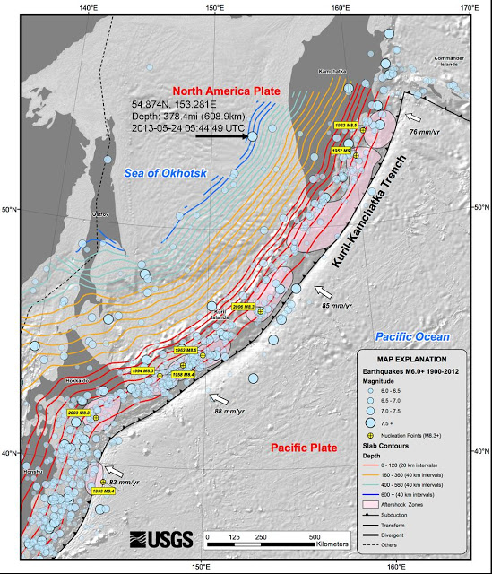
This past week, a very powerful deep earthquake of magnitude 8.3 originating 378 miles beneath the Sea of Okhotsk (west of the Kamchatka Peninsula) has scientists wondering whether this is the most powerful deep earthquake ever recorded.

At 3.8 miles deep or 609 kilometers below the surface, it is not quite as deep as the 395-mile deep (631 kilometer) earthquake that occurred below Bolivia in 1994, but at 8.3 it was more powerful than the Bolivia deep earthquake, which was judged to be 8.2.  

Here are two articles describing the recent deep earthquake below the Sea of Okhotsk, one from the "newsblog" of the journal Nature, and one from the website LiveScience.

Deep earthquakes present some challenges to geologists.  In fact, until the Bolivia earthquake, conventional geologists did not believe that deep earthquakes could approach the power of shallow earthquakes.  That's because conventional geologists believe that earthquakes are primarily driven by the engine of heat, primarily by the heat created by the friction and pressure at plate boundaries, which causes rock to suddenly squeeze into a denser form, leading to rapid realignment of material below the surface that creates a chain reaction from the epicenter which is felt as an earthquake.  

Deep earthquakes pose a problem for that theory, in that the heat and pressure so far below the surface are so great that the mechanism used to explain earthquakes at shallower depths would not seem to be a plausible explanation for deep earthquakes.  Whatever caused deep earthquakes, scientists did not believe that deep earthquakes would be as powerful as shallow earthquakes, but the Bolivia quake challenged that view.

As this New York Times Science Page article published in 1995, in the wake of the powerful Bolivia deep quake,  explains:
These upheavals [deep earthquakes], which occur 200 to 400 miles below the earth's surface, are puzzling in that they ought to be impossible. The pressures and temperatures at that depth are so great that rock should undergo no frictional sliding, the mechanism of garden-variety earthquakes near the surface. So most geologists came to believe that the crushing pressures and increasing heat below a certain depth squeezed the rock into forms that were suddenly denser, creating huge cracks that developed into big temblors.

No more. An extraordinarily big earthquake 395 miles beneath Bolivia last June not only shattered records by jolting cities as far away as Toronto but also left the squeeze theory shaken.

A new analysis of shock waves from that earthquake show its fault zone was 30 miles long and 20 miles wide, too big to be explained by the leading theory. In fact, experts say, the quake bears a disturbing resemblance to big ones that occur near the earth's surface.

"It's embarrassing," said Dr. Paul G. Silver, a geologist at the Carnegie Institution of Washington who questions the old theory. "It looks and acts and talks like these shallow earthquakes. But it shouldn't exist."

As the article goes on to explain, "The mystery is how earthquakes happen at all at remote depths where temperatures may exceed 2,900 degrees Fahrenheit and pressures are 240,000 times greater than those at the surface of the earth. In theory, any rock there should have the consistency of putty, ruling out the brittle fracture and frictional sliding found in faults near the surface."

In spite of the embarrassment of the "experts," that article reassures the reader that: "No matter who wins the intellectual battle, experts agree that deep earthquakes are a general expression of plate tectonics."

Well, that's comforting.

Except that proponents of plate tectonics still have a king-sized problem providing valid explanations for the characteristics of deep earthquakes, as Dr. Walt Brown -- the originator of the hydroplate theory -- explains in great detail in his discussion of the phenomenon.  Here is the beginning of an extended section of his book (the entirety of which can be read online here, or purchased to read in hardcover from his site or from Amazon) dealing with the phenomenon of earthquakes, and discussing the importance of deep earthquakes.

According to the hydroplate theory's model, the reason conventional geologists have a hard time explaining deep earthquakes is that their explanation of all earthquakes is incorrect.  On this page of his book (and the one that follows it), Dr. Brown presents an extended chart that lists features of earthquakes and then compares the hydroplate theory explanation to the tectonic theory explanation for each.  

At the heading of the two columns (hydroplate and tectonic), he explains the two different explanations that the two theories provide for the phenomenon of earthquakes (and the related phenomena of the Pacific basin, including the "Ring of Fire" and the deep Pacific trenches).  

The tectonic model explains earthquakes, deep Pacific trenches, and the "Ring of Fire" (surrounding the Pacific basin) as the product of "subducting plates that have been diving into the mantle for hundreds of millions of years."  As noted above, this explanation sees earthquakes and the related phenomena as primarily driven by heat.

In contrast, the hydroplate theory has a very different explanation.  According to Dr. Brown, "Trenches, earthquakes, and the Ring of Fire are a result of shifts inside the earth during the flood, including the rising of the Atlantic floor and the subsidence of the Pacific floor."  Rather than being driven by heat, these phenomena are primarily driven by gravity, according to the hydroplate theory.

You can explore the list of geological evidence in the two columns and decide for yourself which of the two explanations explains the evidence more satisfactorily.

According to the hydroplate theory, earthquakes today are the result of a cataclysmic event that took place at the time of a global flood.  The initial eruption of floodwaters from under the crust removed the weight of the continents above and led to an upward bulge of the basement rock beneath.  This series of events caused the mid-Atlantic ridge, and led to tremendous friction and melting inside the earth, in a widening cone whose base on the other side of the earth corresponds today (roughly) to the edge of the Pacific basin and the Ring of Fire.

In figure 95, found in note 37 on this page of Dr. Brown's online book, he presents a simplified diagram showing the effect on the inner earth of the proposed upward springing of the floor of the Atlantic after the release of the floodwaters and the erosion of the sides of the continents, which removed weight above the basement rock that forms today's Atlantic floor (this event was discussed in some detail in this previous post). The caption accompanying the image at figure 95 explains:
The mass rising to fill in the blue region of the top cone (the new Atlantic floor) would, as a first approximation, equal the mass passing through the center of the earth. The rock in the yellow cone would experience extreme shearing stresses and deformations, so rock first melted as it approached (and was extruded through) the constriction at the center of the earth. (This is how the earth’s core, shown in red, began.) As the extruded rock melted, it also shrank, by about half, because it was far below the crossover depth. That, in turn, collapsed the deepest foundations on the Pacific side of the earth and produced more shearing deformations and melting immediately above. A runaway situation quickly developed which formed the ring of fire (shown in green), and produced a myriad of fractures in and below the Pacific plate [to see the different colored areas he is describing, visit figure 95 in his book].
(This same sequence of events was also responsible for the creation of our planet's very strong magnetic field, as discussed in this previous blog post). 

Figure 86 (located almost halfway down this page discussing earthquakes, trenches, and the Ring of Fire) shows that earthquakes with magnitudes of 5.0 or greater have a distribution with two peak depths -- one at 22 miles and one at 370 miles beneath the surface.  The distribution chart shows that very few earthquakes originate at 222 miles -- the distribution curve has two distinct groupings of shallow earthquakes and deep earthquakes, with very few at the "crossover point" in between the two groups.  It also shows that earthquakes do not originate at depths greater than 410 miles.  

Dr. Brown's theory has an explanation for this surprising evidence.  His theory argues that earthquakes are caused when rock converges upon a point beneath the surface.  But how could rock converge on a point, unless rock that had been at that point were to somehow disappear to allow the surrounding rock to rush in?  Dr. Brown explains that due to the principles of physics, magma (molten rock) will expand and move upwards (towards the earth's surface) if it is above the crossover depth (of 222 miles), and that it will contract and move downwards (towards the earth's core) if it is below the crossover depth.

Shallow earthquakes are often caused when molten rock expands and moves upwards -- like a beach ball being held under the surface of the water, it wants to get up and eventually paths will open up for it to do so, often quite suddenly and with a chain reaction of further melting of the rock around them.  As this takes place, rock in the area will rapidly rearrange and cause an earthquake.

Deep earthquakes are caused by the same process, except that below the crossover depth the magma contracts and seeks to sink down to the core.  When it manages to do so, the rearrangement of rock that takes place creates a deep earthquake.

These are very broad outlines of the forces involved; for a more complete explanation, the reader is invited to examine the several pages of detailed discussion and diagrams in Dr. Brown's book on this topic.  However, it is important to point out that Dr. Brown's theory links deep earthquakes, the Ring of Fire, and the deep ocean trenches to a single originating event that connects all of them.  As you can see from the maps of this recent powerful deep earthquake, it originated in the vicinity of the Kuril-Kamchatka Trench (see map above from the USGS, with last week's earthquake location pointed out by a black arrow that I added based on the USGS report here).

The conventional explanation for the origin of these trenches, as well as the deep earthquake that took place last week, is that the Pacific plate is subducting or diving underneath another plate along these trenches, and that this subduction creates the trenches and the earthquakes.  As the article linked above from the journal Nature explains, the conventional view is that, "The crust is descending fast enough — about 8 centimetres per year — to remain cool enough to rupture even at great depths. The diving plate is thus seismically active down to 650 kilometres or greater."

Never mind the fact that a thirty-to-sixty mile thick plate diving beneath another plate would create intense pressure and intense heat, which would increase dramatically the deeper the plate went (making the above explanation somewhat problematic), the very idea that subduction is responsible for the deep ocean trenches is fraught with problems.  

One of the biggest of these, as Dr. Brown points out, is the shape of the ocean trenches -- they are frequently arcs, and sometimes they have dramatic cusps.  How could a diving plate create an arc?  As Dr. Brown points out, if you bend a thick paperback book in half (to simulate a plate that is subducting), you will have a very difficult time making that bend resemble an arc (in fact, you won't be able to do it).  

The cusps create an even bigger problem.  In the map above, you can see that the recent deep earthquake near the Kuril-Kamchatka Trench was located almost due west of a point where the trench takes a dramatic 90-degree turn.  What kind of subducting plate could create a trench shaped like that?

There are numerous other problems with the tectonic explanation for the deep ocean trenches (including the fact that almost all of them are located along the western portions of the Pacific basin).  Some of those are discussed in previous blog posts, such as this one and this oneMany more are discussed in detail in Dr. Brown's book.

On the other hand, the mechanism proposed by the hydroplate theory explains the shape and distribution of the deep Pacific ocean trenches very comprehensively, as part of the events of the catastrophic global flood, when the inner earth rose towards the Atlantic and "sucked" the Pacific basin towards the center of the earth.  The evidence supporting this explanation is detailed in Dr. Brown's discussion in points 43 through 56 towards the end of this page in his book.

All of this discussion is not a mere academic argument with no real consequence to our day-to-day lives.  According to Dr. Brown's theory, there could be reasons that powerful and deep earthquakes are becoming more common, and if his theory is correct we could see a tremendous increase in earthquakes at some point in the future.  At the end of the discussion accompanying Figure 87 on this page of his book, Dr. Brown writes:

Drainage into the outer core continues today, releases gigantic amounts of heat throughout the mantle and core,31 and will eventually produce many powerful earthquakes.  When this will happen is uncertain.32
In the footnote at the end of that statement (footnote 32), he restates the same disturbing conclusion:
Nevertheless, earthquakes will someday increase substantially, because heat is building up inside the earth and the shrinkage of rock that melts below the crossover depth increases stresses in the crust and upper mantle. Also, these microscopic movements inside the earth generate heat thousands of times faster than heat escapes at the earth’s surface. This increasing heat melts rock, especially along the relatively hot walls of faults extending from trenches down to the liquid outer core. That melt then lubricates and facilitates further internal movements. [See Endnote 31.]
This prospect for earthquakes increasing "substantially" someday is not exactly comforting.  However, it points to the importance of maintaining the ability to critically examine and question the dominant geological paradigms that inform our understanding of the world around us.  Powerful deep earthquakes such as the one that originated below the Sea of Okhotsk last week expose the weaknesses of the conventional models.  

Events such as this one should cause scientists to consider alternative explanations, such as the theory offered by Dr. Walt Brown, which has a lot of evidence to support it.

Share

Share

The Golden Gate


Above is a beautiful image from Wikimedia Commons of the Golden Gate, the narrow strait opening from the San Francisco Bay (on the left in the image above) into the vast Pacific Ocean (to the right in the image above, which was taken from the North Bay looking south towards San Francisco).  

The Golden Gate is of course spanned by the world famous Golden Gate Bridge, designed and supervised by Joseph Strauss (1870 - 1968) and completed in 1937, which is widely regarded as one of the most beautiful bridges in the world (who are they kidding -- it is undoubtedly the most beautiful bridge in the world).

The Golden Gate is about 1.7 miles wide at the point where the bridge is built across it, and its relative narrowness in comparison to the much larger bodies of water on either side of the strait means that the tides create very swift and powerful currents as the waters flood in from the ocean and then ebb back out in accordance with the tidal cycles each day (for a more detailed look at the tides and the celestial forces which influence them, see this previous post: "Moon, turn the tides . . . gently, gently away").

To understand why the tidal currents through the Golden Gate are so powerful, it may be helpful to imagine the "jet sprayer" faucet feature found on many modern kitchen sinks.  When you turn on your regular kitchen faucet, the water will come out at a certain moderate rate, but when you pull out the "jet sprayer" and depress the trigger, the water will suddenly come out with greatly increased force and pressure, even though you did not increase the water flow at the tap in any way.  Why does the water increase in power so much?  Because it is being forced through a much smaller opening (typically, through many pinhole openings, rather than through one larger faucet opening).  This is similar to the effect you get with a garden hose, when you suddenly constrict the opening with your thumb (again, the smaller gap creates an immediate increase in stream pressure, even though you did not increase the water flow at the tap in any way).

This same principle acts to greatly increase the power of the flood tide and ebb tide through the Golden Gate.  The strength of these tidal currents, and the generally cold water temperatures, helped make the notorious Alcatraz one of the most difficult prisons in the world from which to escape.  Alcatraz is pictured below, to the left of the left-hand tower in the photo as the viewer is looking at the image:


What mighty forces created this narrow gap between the San Francisco Bay and the great Pacific?  Wikipedia vaguely tells us that "San Francisco Bay is thought to represent a down-warping of the Earth's crust between the San Andreas Fault to the west and the Hayward Fault to the east, though the precise nature of this remains under study."  The entry goes on to speculate that a confluence of rivers flowing into this unexplained "down-warping" from the Great Central Valley then created the Golden Gate.

Such an explanation is typical of the kind of "hand wave" often given in place of a rigorous explanation when the conventional models have a hard time dealing with the details of the case.

In contrast, the hydroplate theory of Dr. Walt Brown offers a different hypothesis, based upon the overarching framework of Dr. Brown's comprehensive theory -- a hypothesis which finds evidence to back it up at other narrow straits around the world, and one which makes predictions about what someday will be found beneath the silt that currently blankets the bottom of the Golden Gate.

In the section entitled "Canyons" found near the end of this long webpage in his online book detailing his theory, Dr. Brown explains:
Drainage of the waters that covered the earth left every continental basin filled to the brim with water. Some of these postflood lakes lost more water by evaporation and seepage than they gained by rainfall and drainage from higher elevations. Consequently, they shrank over the centuries. A well-known example was former Lake Bonneville, part of which is now the Great Salt Lake.    
 
Through rainfall and drainage from higher terrain, other lakes gained more water than they lost. Thus, water overflowed each lake’s rim at the lowest point on the rim. The resulting erosion at that point on the rim allowed more water to flow over it. This eroded the cut in the rim even deeper and caused much more water to cut it faster. Therefore, the downcutting accelerated catastrophically. The entire lake quickly dumped through a deep slit, which we today call a canyon. These waters spilled into the next lower basin, causing it to breach its rim and create another canyon. It was like falling dominoes. The most famous canyon of all, the Grand Canyon, formed primarily by the breaching of what we will call Grand Lake. It occupied much of southeast Utah, parts of northeastern Arizona, and small areas of Colorado and New Mexico. [See the map on page 201 and pages 202235.] Grand Lake, standing at an elevation of 5,700 feet above today’s sea level, quickly eroded its natural dam 22 miles southwest of what is now Page, Arizona. As a result, the northwestern boundary of former Hopi Lake (elevation 5,950 feet) was eroded, releasing waters that occupied the present valley of the Little Colorado River.

With thousands of large, high lakes after the flood, many other canyons were carved. “Lake California” filling the Great Central Valley of California carved a canyon (now filled with sediments) under what is now the Golden Gate Bridge in San Francisco. The Strait of Gibraltar was a breach point as the rising Atlantic Ocean eventually spilled eastward into the Mediterranean Basin. The Mediterranean Sea, in turn, spilled eastward over what is now the Bosporus and Dardanelles, forming the Black Sea.
Note that this explanation is rigorous and detailed, it is built upon the fundamental principles of Dr. Brown's overarching theory, and that overarching theory is supported by extensive geological evidence from around the globe (see for instance"The Grand Canyon and the Great Flood," "The Ganges Fan, the Indus Fan, and the Great Flood," "The submarine canyons of California's Central Coast," "Geoids, relative gravity differences, and the deep Pacific trenches," "The bizarre 'barbed tributaries' of Marble Canyon," "Extraordinary sediment deposit from Pakistan to Bhutan supports hydroplate theory," and many others on this blog and in Dr. Brown's book).

It is also important to note that Dr. Brown's theory provides a comprehensive model from which it is possible to make predictions, and that Dr. Brown has published many such predictions in the past.  The ability to make predictions is one of the hallmarks of a true scientific hypothesis. Many of Dr. Brown's predictions have already been proven correct; others have yet to be proven.

In the case of the "downcutting" action described in the passage quoted above, in which large bodies of trapped water, left over from a global flood event, catastrophically breached, leading to the carving-out of V-shaped canyons, Dr. Brown has predicted that:
The crystalline rock under Gibraltar, the Bosporus and Dardanelles, and the Golden Gate Bridge will be found to be eroded into V-shaped notches. (This prediction, first published in 1995, was confirmed for the Bosporus and Dardanelles in 199890 and for Gibraltar in 2009.91)
In other words, Dr. Brown has applied this theory to the straits at the Dardanelles, the Bosporus, and the Straits of Gibraltar (all in the region of the Mediterranean), as well as to the Golden Gate.  He predicted in 1995 that V-shaped canyons could be found under the silt of each of these straits, because he believed that all were carved by the same type of event (the violent breaching of a narrow barrier by a large, trapped body of water). His predictions were later found to be correct in the Bosporus, the Dardanelles, and the Straits of Gibraltar.  

You can see images with cross-sections of the Dardanelles Strait in this scientific publication from September, 2012, showing the type of V-shaped notch predicted by the hydroplate theory.   Dr. Brown's prediction has yet to be proven at the Golden Gate, but perhaps it will be in the future.

The evidence would appear to suggest that the beautiful Golden Gate represents yet another strong supporting argument in favor of the hydroplate theory of Dr. Walt Brown.


Share

Share

Why does earth's inner core spin differently from the rest of the planet?


Here's a link to a recent article entitled "Earth's center is out of sync," which discusses recent work by scientists which reveals more information about earth's inner core, thousands of miles beneath our feet.

The article discusses a new study published in Nature Geoscience entitled "The shuffling nature of Earth's inner core revealed by earthquake doublets," by Hrvoje Tkalčić, Mallory Young, Silvie Ngo and Malcolm Sambridge of the Australian National University, Canberra, and by Thomas Bodin of UC Berkeley's Berkeley Seismology Laboratory.

The scientists used measurements of the waves sent through the earth by earthquakes and determined that, not only does earth's solid inner core rotate at a different rate than does the outer earth (which similar studies of earthquake waves had previously suggested) but that this different rotation rate of the inner core varies with time.

Why does the earth's inner core, which is thought to be a solid ball of nickel and iron (primarily) at the very center of the earth, surrounded by a molten outer core, rotate at a different rate -- and in a slightly different direction -- from the rest of the earth?

The answer to that question (as with many other questions involving earth geology) will depend upon the framework or model that informs the person giving the answer.  

As you might expect, the hydroplate theory of Dr. Walt Brown provides an answer for this phenomenon, and one which fits in with the hydroplate theory's description of events which would have taken place surrounding the catastrophic global flood which shaped so many of the features we see around us on the planet's surface.

The hydroplate theory argues that the eruption of massive amounts of water trapped beneath earth's crust removed enough continental material to cause the basement rock to bulge "upwards" (away from earth's center), which created the mid-oceanic ridge.  This upward-bulge motion created massive frictional heating and melting inside the earth, but that's not all -- it also caused a massive suction "inwards" (towards the earth's center) on the opposite side of the planet, creating the "hole" that today is known as the Pacific basin.  This shifting of material inside the earth caused enormous friction and melting.

This event also caused the continents to slide away from the center of the Atlantic and towards the newly-created Pacific, a slide which led to the creation of almost all the terrain features we see around us.

Dr. Brown explains how the internal shifting of mass and the accompanying friction and melting led to the creation of both the solid inner core and the liquid outer core of the earth (found in the chapter entitled "The Origin of Ocean Trenches, Earthquakes, and the Ring of Fire" in his book, available online in its entirety here):
Suppose the inner earth initially had a more uniform mixture of minerals. Heating would first melt minerals with lower melting temperatures, which would allow denser grains to settle and lighter grains to rise, a process called gravitational settling. This would generate much more heat and produce more faulting, melting, and gravitational settling. After many such cycles, the earth’s core would form with solid, denser minerals (containing iron and nickel) settling to form the inner core and the melt forming the liquid outer core. Shifting so much mass toward the center of the earth and doubling the density of the rock melting below the crossover depth would increase earth’s rotational speed. Today, the earth spins 365.256 times each year, but there are historical reasons for concluding that a year once had 360 days.35 [For details, see "Melting the Inner Earth" on pages 535538.]

We saw that the skater in Figure 81 spins faster as she draws her arms closer to her spin axis. Likewise, as denser minerals settled through the magma toward the center of the earth, the inner core spun faster than the outer earth. The inner core is still spinning faster (by about 0.4° per year),36 because the liquid outer core allows slippage.
The above quotation, along with helpful illustrations and diagrams, can be found on this page of that online chapter.  

The sequence of events proposed by the hydroplate theory clearly explain the origin of a solid metal core suspended in a liquid molten outer core.  The situation arose from the massive changes wrought by the bulging upwards on the Atlantic side which pulled rock upwards all the way through the earth to pull rock inwards and downwards on the Pacific side.  Molten rock below a certain depth (called the "crossover depth") sank towards earth's center, where the heaviest and densest materials (primarily nickel and iron) formed the inner crust, and the less dense molten liquid material remained as the outer core.

Dr. Brown explains this process more fully, with plentiful technical details and supporting formulas, in notes referenced and linked in the above block quotation, which can be found here.  Part of that extended discussion reads:
[. . .] during the flood, mass shifts within the Earth generated internal friction, heating, and melting. Melting, especially near the center of the Earth where pressures (and thus frictional heating) were greatest, was followed by gravitational settling of the denser minerals and chemical elements. Rock that melted below the crossover depth contracted. [See “Magma Production and Movement” on page 154.] This produced further mass shifts (faulting), frictional heating, melting, and gravitational settling.  [. . .]

Particles that melted after they fell added to the liquid outer core; denser particles that did not melt or that solidified under the great pressure near the Earth’s center formed the solid inner core. 
The details given also explain why the core of the earth is so hot, and why it spins at a different rate than the rest of the earth.  Like an ice skater going into a spin and pulling in her arms and legs, this process sped up the rotation of the solid inner core inside its liquid outer core.

Dr. Brown once explained to me in a telephone conversation that if the earth were to somehow become transparent so that we could see all the way down to the inner core, we would be able to see that it was rotating at a different speed and direction that we are out here on the earth's surface.  We don't perceive the earth's rotation, so we would feel as though we were staying still, but even so we would see the earth's inner core rotating -- a most amazing thought!  It is probably a fact of which most people are completely unaware -- I was certainly unaware of it until he explained it to me that day.

The hydroplate theory proposes a mechanism by which this startling situation could have come about, and one which fits in with the series of events that would explain so many other pieces of geological evidence on our earth's surface.  The ongoing findings of scientists regarding the inner core appears to be additional supporting evidence for the hydroplate theory.

On the other hand, conventional explanations run into some problems in explaining how the earth's solid inner core and molten outer core originated, as Dr. Brown explains in note 21 on this page of his online book.  This discussion is also very closely related to the question of how earth obtained such a strong magnetic field, which is also covered by the hydroplate theory and discussed in this previous blog post.

Based on the truly astonishing amount of geophysical evidence which Dr. Brown's theory explains, it should be carefully considered as a strong contender for understanding our planet.

Share

Share

Embryonic Lufengosaurus fossils and the hydroplate theory of Dr. Walt Brown


Special thanks to Farmer Dan V., an old friend from the airborne days, for alerting me to this fascinating account of the discovery of fossilized dinosaur embryos in southern China (Lufeng County, Yunnan Province), identified as Lufengosaurus, a sauropod reaching lengths of 30 feet.  An adult skeleton of a Lufengosaur is shown above.

The article discusses a report published in the journal Nature, entitled "Embryology of Early Jurassic dinosaur from China, with evidence of preserved organic remains," was written by a team of scientists led by paleontologist Dr. Robert Reisz of the University of Toronto, Mississauga campus.

The fossils are unique in that, unlike other fossilized dinosaur eggs, these allow the paleontologists to study the bones of the developing fossils that are usually inside and unable to be studied.  This enables the bone sizes to be studied in order to determine growth rates of this species before they hatched.  Scientists had previously studied growth rates of young dinosaurs after they hatched, but had not been able to study growth rates that dinosaurs might have undergone before hatching.  As the abstract to the paper explains:
The preservation of numerous disarticulated skeletal elements and eggshells in this monotaxic bone bed, representing different stages of incubation and therefore derived from different nests, provides opportunities for new investigations of dinosaur embryology in a clade noted for gigantism.
The fossils suggest very rapid growth, as well as the development and flexing of muscles while still in the egg (something the paleontologists deduced from the asymmetric development of the cross-sections of the leg bones, suggesting that muscle attachments and embryonic muscle flexing were influencing the shape of the developing bones).

How was this monotaxic archaeological treasure trove (a monotaxic site contains the remains of a single taxon or species form, which can be very valuable for comparison and analysis) preserved in the first place?  As the article notes, the scientists believe that "a flood swept through a dinosaur nesting site in what is now southern China. Dozens of embryos were suffocated in their eggs and their bones were separated from each other, carried away, and buried under sediment."

Note that this explanation is in fact consistent with the hydroplate theory of Dr. Walt Brown.  Preserving dinosaur embryos would require some extremely unusual conditions, including the rapid flooding and burial under thick wet sediment described above, in order to prevent total bacterial decomposition that eventually takes place under ordinary circumstances. 

In fact, not only are embryonic fossils difficult to preserve, but all fossils fall into this same category: under normal circumstances, bacteria and other organisms break down all dead creatures, whether full-grown or unhatched.  Thus, the existence of fossilized bones from an adult Lufengosaurus is just as incredible as the existence of these embryonic fossils.  For more on this subject, see this post and many others previously published on this blog.

Perhaps the most astonishing piece of information revealed in the study published last month by Dr. Reisz is the revelation that the paleontologists also found "preserved organic remains" in these embryonic fossils -- meaning actual dinosaur tissue that had not been turned to mineral but still contained protein!  This article in PhysOrg gives more detail on that astounding discovery.  In it, Dr. Reisz is quoted as saying:
The bones of ancient animals are transformed to rock during the fossilization process," says Reisz. "To find remnants of proteins in the embryos is really remarkable, particularly since these specimens are over 100 million years older than other fossils containing similar organic material.

Read more at: http://phys.org/news/2013-04-world-oldest-dinosaur-embryo-bonebed.html#jCp
The bones of ancient animals are transformed to rock during the fossilization process.  To find remnants of proteins in the embryos is really remarkable, particularly since these specimens are over 100 million years older than other fossils containing similar organic material.
The scientists believe that the Lufengosaurus fossils come from a period of time between 190 million and 197 million years ago.  The other fossils with preserved soft tissues to which Dr. Reisz is referring are those found in the bones of a T. Rex from "only" 68 million years ago, which means that these Lufengosaurs, if properly dated, predate those preserved tissues by almost another 130 million years!

This previous post entitled "Soft tissue in T. Rex fossils" explains the king-sized problems those T. Rex tissues caused scientists devoted to the conventional models of geology and fossil dating. The problem was that other scientific research had shown that such soft tissue structures could not last more than 10 million years.  Instead of questioning whether their model for dating the fossils might be based on faulty assumptions, they revised their estimate of the length of time that soft tissues could survive.  Looks as though they will have to revise it again!

Of course, they could also consider the possibility that all the strata were laid down rapidly, at the same time, during a cataclysmic global flood, as literally hundreds or even thousands of other independent pieces of evidence around the world appear to suggest.  This possibility is discussed in this previous post and this previous post, among others. In that case, these soft tissue fossils may be far less than 68 million years old (for the T. Rex) and 197 million years old (for the Lufengosaurus).  

However, there appears to be very little chance that such reconsideration will take place, even after this amazing discovery and article by Dr. Reisz and his colleagues.  Most people are too wedded to their foundational assumptions to question them to that extent, just as they were when Alfred Wegener first proposed his radical (for their time) geological theories back in 1912.

In any event, this new fossil discovery appears to be incredibly important in many ways, not least the fact that it adds substantial additional evidence that may support a completely different geological model than the one that is currently dominant.
The bones of ancient animals are transformed to rock during the fossilization process," says Reisz. "To find remnants of proteins in the embryos is really remarkable, particularly since these specimens are over 100 million years older than other fossils containing similar organic material.

Read more at: http://phys.org/news/2013-04-world-oldest-dinosaur-embryo-bonebed.html#jCp

Share

Share

The submarine canyons of California's Central Coast

(mobile users please scroll down to read the post)

One of the strongest pieces of evidence supporting the sequence of events proposed by Dr. Walt Brown's hydroplate theory, in my opinion, are the world's numerous and extensive submarine canyons.  

Submarine canyons are enormous undersea "river systems" which cascade down the sides of the continental shelf of many different continents, often at places where water even today empties into the sea, such as at the mouth of the Ganges River in India, the mouth of the Congo River in Africa, and along the continental shelf beyond the mouth of the Hudson River in North America.  

Submarine canyons are thus very different from the deep ocean trenches, in that they "run off" the continents, plow down the sides of the continental shelf of the various continents, and look a lot like river systems (some even have "tributaries" feeding into them in their upper reaches).  Previous posts have discussed the importance of these dramatic pieces of evidence and their implications for our view of what might have happened in the past to shape our planet's geological features: some of those include "The Ganges Fan, the Indus Fan, and the Great Flood" and "Back from the Great Central Valley." 

Those posts discuss the fact that these huge submarine canyons pose a major problem for the tectonic theory, in that the tectonic theory appears to be a poor fit for the evidence in this case.  They certainly do not seem to be the product of one plate subducting under another plate (the explanation given for the deep ocean trenches by advocates of the tectonic theory -- for some discussion of the problems the deep ocean trenches pose for the conventional tectonic theory, see previous posts such as this one, this one, and this one). 

Anyone looking at imagery of these submarine canyons would immediately suspect that they were carved by rushing water, or by river systems in the distant past, so similar are they to the rivers we see on land.  However the tectonic theory has difficulty with this explanation as well -- if they were carved by water at some time in the past when they were not below the ocean's level, then what mechanism of tectonics brought them down to their current submarine location?  Some of these canyons, Dr. Brown points out, rat stedepths of 15,000 feet below the surface -- did some tectonic mechanism bring them down that far?  And why are these canyons always running off the sides of the continental shelves?  Do tectonic proponents mean to tell us that all the steep continental shelves were once plains upon which rivers flowed, before some mysterious process of tectonics tilted them into their current position?

The hydroplate theory, however, explains these canyons quite well.  It proposes that the catastrophic global flood covered the earth and that the continents slid during that event (still covered with water) to their present location.  The forces which caused the continents to slide during that event are discussed in this post among others, as well as in Dr. Brown's online book in much greater detail.  At the end of that slide, there was tremendous buckling and thickening of the continents, thrusting up the mountain ranges we see today and causing water to run off into the ocean basins (which were created by powerful forces related to the flood event, also described in Dr. Brown's book in greater detail).  This runoff would explain the submarine canyons, as water pouring down the continental shelf of each continent would carve huge canyons before the ocean later rose to submerge them.  Dr. Brown's theory also explains why for some period of many years after this flood (and after the main runoff event), the ocean levels would have been much lower.

This proposed sequence of events explains the evidence that we find today much more reasonably than does the tectonic explanation.  If the geology of our earth were to be thought of as a "crime scene," then the hydroplate theory explains that evidence much better than the other theories that have been put forward to date.  

Above is an image from Google Maps of a distinctive submarine canyon which plunges down the continental shelf off the coast of California at Lompoc, west of Santa Barbara and "north" along California's Central Coast from Santa Barbara (the Central Coast of California is generally identified as the coast area between Santa Barbara in the south and Monterey in the north).  It looks like an enormous hydra, with six major "tributaries" flowing into it just off the coastline, resembling a river delta except for the fact that a river delta usually forms at the lowest area of a river where it flows into the sea, and this "delta" is found at the highest part of the Lompoc sumbarine canyon system.  Below is a closer view of the canyon:


Below is another image, zoomed-in still further, showing just how massive this canyon really is.  Look at the size of the "tributaries," each of which is narrower than the main canyon below the point where they all flow together, and compare it to the size of the town of Lompoc itself:


This dramatic submarine canyon is not alone on California's Central Coast -- further north are numerous others, including the massive and much more well-known Monterey Canyon, an image of which was shown at the bottom of this previous post.  Before reaching the Monterey Canyon, however, you will find other mighty submarine canyons coursing down the steep slope of the continental shelf.  Two of the most impressive snake down below the towering cliffs of the Big Sur coastline, also fed by a major "delta" of "tributaries" as seen in the following picture:


These geological features clearly appear to be the product of flowing water, and yet they are today covered by ocean.  What could have caused the dramatic "fans" seen in the above image, if not running water prior to the ocean filling up to its current levels?  The hydroplate theory of Dr. Brown explains the formation of these canyons quite satisfactorily, while this evidence poses serious difficulties for other geological theories.

Below is a more "zoomed-out" view of a much larger segment of the Central Coast, showing the Monterey Canyon, the two Big Sur submarine canyons, and at the south end of the image the Lompoc sumbarine canyon:


This website, from the US government's National Oceanic and Atmospheric Administration (NOAA) and  contains a conventional explanation for these canyons, attempting to fit the evidence into the tectonic theory:
Monterey Canyon cuts across the generally north-south trending offshore faults in Monterey Bay. It is a large submarine canyon that bisects the Bay and has eroded deeply into the Salinian block and the overlying Neogene sedimentary rocks of the Miocene Monterey Formation, Santa Cruz Mudstone, Santa Margarita Formation, and the Pliocene Purisima Formation (Shepard and Dill 1966; Martin 1969; Greene 1970, 1990; Greene et al. 1991). The canyon is the result of tectonic activity occurring ever since subduction of the Pacific Plate ceased and transform motion began, about 21 million years ago (Atwater 1970; Greene 1977, 1990; Greene et al. 1989, 1991). Landslides and turbidity currents created by mass wasting events (Greene et al. 1991, and see Mass Wasting) steepen the canyon's walls, expose basement and bedrock, and erode the canyon. 
So, the author of this explanation declares that the Monterey Canyon "is the result of tectonic activity" that was later augmented by "landslides and turbidity currents."   This explanation strains credulity.  Did tectonic motion create the Monterey Canyon, the two Big Sur submarine canyons with their "fans" feeding into them, and the hydra-shaped Lompoc submarine canyon?  What strange motion of tectonics can be proposed to explain such tectonic features?  Why would these products of tectonics mimic the shape of river channels to such an astonishing degree?  The reader can decide for himself or herself which proposed explanation seems more likely.

Further, as has already been discussed at great length in previous posts, the entire California Coast from the region of these canyons all the way to the north of the San Francisco Bay is marked by distinctive submarine "hogbacks," indicating uplift that was strong enough to split the sedimentary layers and tilt them upwards until they pointed skyward instead of lying horizontal.  This motion parallels the coastline, but the direction of the canyons cuts perpendicular to these hogbacks.  Proponents of tectonics have to posit tectonic motion in one direction, followed by tectonic motion in an almost perpendicular direction to the previous motion.  

It is convenient that they can dream up tectonic plates that move about in just such a way as to fit their desired storyline. However, I believe that the hydroplate theory makes much more sense.  According to the hydroplate theory, the strata were laid down during the "flood phase" of the catastrophic global event described by Dr. Brown, and then the continents began to slide.  The violent forces at the leading edge of the sliding North American continent created the buckling forces that created the Sierra Nevada mountains, and also thickened the continent at the leading edge to such a degree that the sediments split on either side of the "lip" that separates the Central Valley from the Pacific Ocean.  All along this uplifted terrain, on either side, California has long parallel hogbacks running north to south.  These are below the ocean just off the coast, as well as on the western edge of the Great Central Valley.  This previous post, entitled "Hogbacks of the California Coast" discusses the geological evidence and provides some images from Google Maps of the hogbacks of California.  

Incidentally, the hogbacks off the coast at Half Moon Bay appear to be partly responsible for the famous big-wave at Mavericks (see here). 

Below is an image from Google Maps of some of the submarine hogbacks just to the north of the canyon at Lompoc, from the seafloor off the coast of Cambria, California:


Here is another set of now-submerged hogbacks which are even closer to Lompoc, found off the coast of the Montana de Oro State Park just north of the San Luis Obispo Bay:


This previous post also shows hogbacks in the vicinity of Lompoc, including some that are on land along the coastline very close to Lompoc, south and east of the town itself.

All of these hogbacks demonstrate the tremendous and violent forces that accompanied the slide of the continental plates during the flood event, and indicate the direction of the forces that were then taking place.  Tectonic advocates would say that the slow centimeters-per-year drifting of tectonic plates gradually tipped the strata upwards to form the hogbacks found around the world, although this post discusses the laws of physics that argue against the very gradual motion of tectonics to be able to cause all the features that are attributed to this slow motion.  In any event, even if the tectonic advocates argue that all these hogbacks are the product of slowly-drifting plates, the motion is completely in the wrong direction to create the submarine canyons.  One would be tempted to ask them, "Which direction is it?  You can't have it both ways," except that they apparently do think they can have it both ways.  

The submarine canyons of California's Central Coast constitute yet another set of evidence for the examination of open-minded individuals who wish to weigh the various possible explanations for what causes our earth to look the way it does today.  In my opinion, the explanation of Dr. Walt Brown's hydroplate theory is overwhelmingly more rational in explaining the evidence that we do find than is the explanation proposed by the conventional tectonic theory.  Further, there are hundreds of other pieces of geological evidence around the globe which also appear to be better explained by the hydroplate theory than by the tectonic theory.  However, all thinking people should be free to examine the evidence and decide for themselves.

Share

Share

Plant fossils in the deep ocean trenches?


The Mariana Trench is famous for having the deepest known point in the ocean, Challenger Deep (36,000 feet), which was discussed in this previous blog post.  However, prior to the Challenger Expedition of 1951, the deepest known point was the Galathea Depth (34,600 feet), at the bottom of the Philippine Trench, at the area indicated by the large arrow in the image above.  This point, named for the Galathea Deep Sea Expedition of 1950-1952, remains the third-deepest known location in the world to this day.

The Galathea Expedition was a Danish oceanography expedition whose purpose is described in this report from the expedition itself, beginning on page 26.  That purpose was "to explore the ocean trenches in order to find out whether life occurred under the extreme conditions prevailing there -- and if so, to what extent" (26).  In addition to making extensive notes on deep-sea life that it discovered, the Galathea Expedition also reported plant remnants and fossil plant remnants from the lowest depths of the Philippine Trench -- a truly remarkable discovery.

How did plant material find its way to the bottom of the Philippine Trench, and how did plant fossils occur there?  It is quite clear that no plants can grow at such depths, isolated from the light of the sun by six miles of water above them.  The discovery of fossils of organisms that could only grow on land or perhaps in very shallow waters at some of the deepest points in the ocean parallels the discovery of marine fossils atop Mt. Everest, earth's the highest point (those fossils are discussed here).

Dr. Walt Brown, the originator of the hydroplate theory, discusses both sets of evidence, and argues that his theory provides a more reasonable explanation for these remarkable discoveries than the conventional theory.  The discussion of the deep ocean trenches, and the mechanism that caused them according to the hydroplate theory, can be found here.

The reports from the Galathea Expedition, such as this one which discusses this material on pages 15 - 17, propose that turbidity currents may have carried the plant material to these depths, and that is certainly a possible explanation.  However, even if we allow that such currents could have moved plant matter down that far, we still must account for the fact that they turned into fossils.  As we have discussed in many previous posts (such as this one), unusual conditions are necessary to create any fossils, whether on land or in the ocean.  Organic matter must generally be buried rapidly in something like thick wet mud, to keep bacteria from breaking it down -- given enough time, these bacteria would even break down bone, preventing the formation of a fossil.

Again, the turbidity currents could have been accompanied by mud flows which then buried the matter and allowed it to fossilize.  Another possibility is that fossils formed in shallower water and then the "conveyor belt" action proposed by plate tectonics drew the plates along over the millennia until the land fossils (or shallow-water fossils) ended up in the deep-sea trenches.  

Arguing against this explanation, however, Dr. Brown points out that "Because plants float and quickly disintegrate, they should not be buried and preserved in one of the deepest parts of the Pacific Ocean" (see point 24 on this page of his online version of his book).  He also points out that the sedimentary layers in the deep ocean trenches are undisturbed -- if plates were truly subducting the way tectonics advocates say that they are, these sedimentary layers should be violently disturbed by this ongoing activity.  This argument is given as one of the sixteen reasons he shows that plates are not subducting in the ocean floor, found in Table 4 on this page of his book.

On the other hand, Dr. Brown's theory has no trouble explaining the presence of fossils at the bottom of the deepest ocean trenches.  He argues that these deep ocean trenches were caused by downward pulling pressure from beneath the Pacific basin itself -- that they were basically sucked down, not pushed down by subduction.  The force that pulled the floor of the Pacific toward the other side of the globe was the result of the powerful mechanism that unleashed the global flood itself: a powerful rupture releasing water that had been trapped under the earth's surface, which jetted upward and eroded the crust above the rupture, allowing the basement to spring upward as the weight above was released.  When the earth bulged upward on the Atlantic side, creating the Mid-Atlantic Ridge and initiating the slide of the continents away from the rupture, the floor of what would become the Pacific, on the opposite side of the globe, was sucked downward towards the center of the earth, creating the deep ocean trenches which form distinctive "arc-and-cusp" patterns that are much more consistent with this explanation than with the theory of subducting plates.

This explanation is consistent with fossils from land or shallow-water plant species now located at the bottom of the deepest trenches.  As Dr. Brown explains, "It should be no surprise that the global flood, which fossilized trillions of animals worldwide, also formed fossils in places that later became ocean trenches. Rapid burial, necessary to form and preserve fossils, was quickly followed by the subsidence of the Pacific plate and the downward buckling of trenches" (this page, point 23).

The evidence from the bottom of the deepest parts of the ocean should be considered along with all the other extensive evidence from around the globe, and then the theories that attempt to tie all this evidence together should be compared to see whether they can adequately explain all of the evidence, and to see which theories have difficulty with various pieces of evidence.  In my opinion, there is really no comparison.  There are literally hundreds of pieces of evidence which appear to be better explained by the hydroplate theory than by the tectonic theory.  The tectonic theory certainly explains evidence better than the theories that it replaced, but it has major problems with many pieces of geological evidence that the hydroplate theory explains quite well.

The fossils at the deepest ocean trenches appear to join with the fossils at the highest mountain tops in declaring the truth about the earth's violent past.


Share

Share

The bizarre "barbed tributaries" of Marble Canyon


Above is a beautiful image taken from the platform of the space shuttle Discovery in 1985, showing the Grand Canyon in November (south is at the top of this image, and north is at the bottom).  This image is not only breathtaking, but also clearly reveals many of the important pieces of geological evidence about the Grand Canyon which support a catastrophic mechanism for its creation, as opposed to the uniformitarian explanations which are commonly foisted upon the public.

Specifically, these pieces of evidence are features which Dr. Walt Brown discusses in the chapter of his book in which he discusses the Grand Canyon and the facts there which support his hydroplate theory, a theory which proposes that almost all of the geological features of our planet were shaped in the events surrounding a catastrophic global flood.  In that chapter, he proposes that the Grand Canyon was formed when waters trapped after the flood in two huge lakes (which he names "Grand Lake" and "Hopi Lake") breached and poured out with tremendous violence, carving the awe-inspiring wonder of the world that we know today.

Some of the evidence which can be seen in the NASA image which refute the standard explanation that the Colorado River gradually carved out the Grand Canyon over millions of years include the Colorado River's dramatic "right turn" in which it plows right through the massif of the Kaibab Plateau (which is labeled in the image below), as well as the many mysterious canyons that lead into the path that the Colorado River takes but which seem to have no perceptible source.  

Previous posts have discussed the formation of the Grand Canyon and the way that Dr. Brown's theory can explain the path right through the Kaibab Plateau (while conventional theories have great difficulty explaining this geological fact).  To revisit some of the previous discussion of the Grand Canyon and surrounds, see for example:
Let's now examine these mysterious side canyons, which this superb space shuttle image make so easy to see, in a bit more detail.

In a section entitled "Side Canyons" on this page of his online book in the chapter on the Grand Canyon, Dr. Brown explains some of the enigmatic features of these side canyons which make them very difficult to account for if using conventional uniformitarian theories of gradual erosion by the Colorado River:
Dozens of large side canyons intersect the main trunk of Grand and Marble Canyons and cut down to the level of the Colorado River. These side canyons also have their own side canyons, all connected like branches on a big, bushy tree. Surprisingly, most side canyons, at least today, have no source of water that could have carved them—or basins above that could have held much water.  
Even more difficult to explain is the direction of some of these side canyons, which some geologists call "barbed" canyons, because they come into the main river path from what would seem to be the "wrong direction."  Dr. Brown writes:
A few side canyons are “barbed.” That is, they connect to the main canyon “backwards,” similar to the barbs in barbed wire or fishhooks. Tributaries almost always enter rivers at acute angles, but the barbed canyons are oriented at obtuse angles. Very strange.15 What happened? 
The footnote is to a description from a book by geologist, trail guide and author Wayne Ranney, entitled Carving Grand Canyon:  Evidence, Theory, and Mysteries, in which Mr. Ranney writes:
Additionally, in Marble Canyon, many tributary streams come into the Colorado River flowing generally to the north, against the southerly flow of the modern river. This creates a pattern of drainage known to geologists as "barbed" tributaries. The Marble Platform, into which the tributaries have been carved, also slopes down to the northeast exactly opposite the flow direction of the modern river.  23.
The image below (same NASA image, with additional markings and labels) points out a two of these barbed canyons.  Note that they are intersecting the main channel of the Colorado from south to north, even though the Colorado River is flowing from north to south:


Strictly speaking, as noted in Mr. Ranney's quotation above, these barbed canyons are found in the portion of the overall canyon complex known as Marble Canyon, which is the name given to the canyon section between Lee's Ferry and the point where the Little Colorado River comes into the path of the Colorado River (see map below):


Note, of course, that unlike the previous two images, this map is oriented with north at the top rather than at the bottom.  The barbed canyons along the path of Marble Canyon are clearly visible, especially along the section of Marble Canyon just south of the arrow indicating the location of Lee's Ferry.

So, what could account for these strange barbed canyons, which appear from no apparent source and enter the Colorado River and the main channel of the canyon from a generally south-to-north angle instead of coming in the same way that the river flows, namely north-to-south?  

The standard uniformitarian answer involves, of course, long periods of time, and posits that drainage plain between the Kaibab Plateau and the canyon allowed the runoff from occasional thunderstorms to gather itself together into channels that flowed from south-to-north, and that the drainage plain on the other side, between the canyon and the Vermillion and Echo Cliffs, did the same thing.  The Vermillion and Echo Cliffs are the line of cliffs through which the tell-tale "funnel" feature can be seen to erupt -- Lee's Ferry is right in the middle of this funnel.

This uniformitarian explanation relies on the idea that the line of the Vermillion and Echo Cliffs slowly retreats to the northeast, due to erosion, while the hump of the Kaibab Plateau remains anchored in place.  This northward retreat causes the water to run generally from the higher ground in the direction of the Kaibab towards the lower ground in the direction of the retreating cliffs -- thus, the runoff from the annual wet season goes towards the north.  

That is certainly one possible explanation.  Readers should examine the evidence closely and see whether it fits what is seen "on the ground," and whether does a better job than other theories at explaining the features in the area, including the cliffs, the funnel, Marble Canyon itself, and the deep barbed canyons running into it from the south on either side.  

This and other competing explanations should be compared against the detailed explanation offered by Dr. Brown in his book -- one aspect of his book that I think is very laudable is Dr. Brown's comparison of competing explanations, which he tries to present as fairly as possible.  He then points out evidence that each theory (including his own) has difficulty explaining, and evidence that each theory explains well.

This webpage from Dr. Brown's online book gives a detailed explanation, with terrific photographs, of the geology of Marble Canyon, and the forces that he believes created its incredible features, including the barbed canyons.  

He explains that the Vermillion and Echo Cliffs were originally joined in one long cliff-line, which was uplifted as a reaction to the sinking down of the newly-formed Rocky Mountains further west (the Rockies having been created by the violent buckling of the hydroplates that had been sliding away from the rupture in the earth's crust that started the flood to begin with -- this previous post explains why the principles of physics tell us that the creation of huge mountain ranges such as the Rockies require more force than the tectonic theory can muster).  

The huge lakes trapped on this uplifted Colorado Plateau during the recovery phase after the flood (after the floodwaters drained into the ocean basins -- creating huge submarine canyons still visible today and difficult to explain by uniformitarian theories) eventually breached, starting with the northern of the two lakes, a breach which created the huge funnel clearly visible in the map above in the middle of which is Lee's Ferry.  This breaching water did not carve Marble Canyon; rather, it blasted away all the soft sedimentary layers (the ones that uniformitarians call the "mesozoic" layers) in the path of the funnel, stripping away down to the harder and more brittle limestone below.

Dr. Brown explains:
Suddenly, Grand Lake breaches a point on its bank and catastrophically erodes the soft Mesozoic sediments, forming a gigantic spillway—a steep, 18-mile-long channel shaped like a widening funnel. The escaping water’s large volume and high velocity erodes the far end of the funnel within weeks to a width of 12 miles and a depth of 2,000 feet.

Marble Canyon. The originally horizontal sedimentary layers below the floor of the funnel steadily arch upward as weight is removed by this downward erosion. Eventually, the funnel’s floor—hard, brittle Kaibab Limestone—cracks in tension, splitting open the entire floor parallel to the funnel’s axis, forming Marble Canyon. [See Figure 121.] 
Dr. Brown explains that the removal of all that earth in the funnel allowed subsurface water to gush out the newly-formed cliff-sides of the funnel, and down into the floor of the funnel, where it created a maze of tiny tributaries flowing into the crack that we call Marble Canyon.  However, the upward-arching action of the hard limestone floor that followed the removal of the sediments above and created the crack in the first place also created a north-to-south slope for that water to follow.  

As these torrents flowed together, they ran into "sinkholes" created by subsurface waters that were spilling down into the crack of Marble Canyon.  These sinkholes were actually "sink-canyons," as an examination of the weirdly collapsed layers seen in Dr. Brown's Figure 124 (linked in his paragraph quoted above) reveals.  The subsurface water spilling into Marble Canyon created sink-canyons (the same way that sinkholes form in limestone in other parts of North America, such as the southeast), which invited the torrents of water that was spilling out of the cliff-sides of the funnel onto the funnel floor, and these torrents of water further deepened those sink-canyons that became the barbed canyons we see today.  They intersect the crack of Marble Canyon from a south-to-north direction because the upward-arching of the funnel-floor after the softer Mesozoic sediments were removed was greater at the wider end of the funnel than at the narrow end of the funnel.

Further evidence to support this theory can be seen in the tipped layers at the base of the cliffs on either side of the "funnel," which Dr. Brown shows clearly in his Figure 120 and explains in the caption beneath.

The reader is invited to compare all the possible explanations for the very distinctive series of geological phenomena surrounding Marble Canyon and its barbed canyons.  Ask yourself which explanation does the best job of accounting for the truly bizarre features of these barbed canyons, the size and shape of the funnel itself, and the dramatic upward-arching of the layers in the cliffs that form the sides of the funnel.

Note that even if the reader decides that the uniformitarian explanation does a better job (and I personally think that would be a dubious conclusion), that still leaves the mystery of the Grand Canyon's pathway through the Kaibab Plateau to explain, as well as the origin of the Little Colorado River and its own (less distinctive) funnel region.  These geological features are comprehensively explained by the hydroplate theory account, but not by the conventional explanation for the barbed canyons.

I believe that the fantastic barbed canyons of the Marble Canyon region of the Grand Canyon complex are an often-overlooked but extremely powerful argument in support of Dr. Brown's theory.  


Share