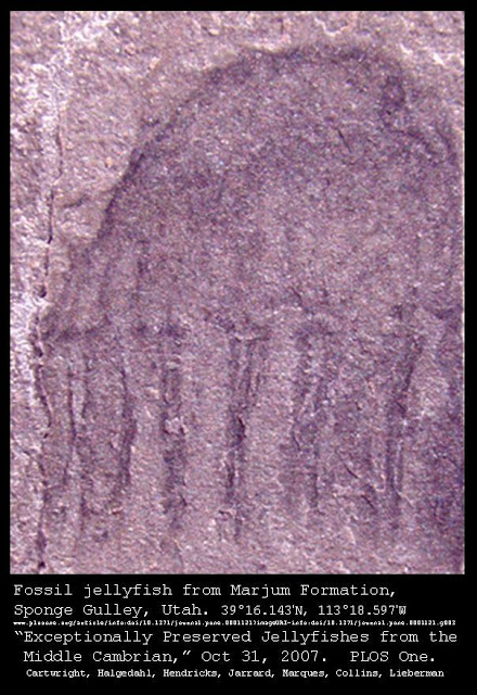
Here's an image of something quite astonishing: the fossilized remains of a jellyfish, preserved in fine-grained sedimentary rock in Utah, in the southwest of the United States.
It is one of a number of exceptionally well-preserved fossil jellyfish which display trailing tentacles, radial muscles, subumbrellar and exumbrellar surfaces, and even possibly gonads -- enough soft-tissue features to definitively categorize them as jellyfish fossils.
There have been other instances of extensive preservation of numerous jellyfish fossils, such as the amazing discovery of numerous large jellyfish imprints (or "trace fossils") in Wisconsin, but those fossils were found in sedimentary rock created from much coarser sand, and thus they do not preserve the same exquisitely-preserved features of the more-recent Utah find. Some skeptical paleontologists have even speculated that the Wisconsin jellyfish impressions could have been made by something other than jellyfish (see this article about the Wisconsin jellyfish fossils for some discussion).
These particular jellyfish fossils found in Utah were first described in a peer-reviewed article published in PLOS One in October, 2007, written by scientists Paulyn Cartwright, Susan L. Halgedahl, Jonathan R. Hendricks, Richard D. Jarrard, Antonio C. Marques, Allen G. Collins, and Bruce S. Lieberman and entitled "Exceptionally Preserved Jellyfishes from the Middle Cambrian." It makes for fascinating reading.
The authors believe, based on widely-held assumptions about the formation mechanisms that created the stratigraphic layers of sedimentary rock on our planet, that these jellyfish are between 501 million and 507 million years old, and date them to about 505 million years ago.
We have already discussed in several past blog posts, such as this one, the possibility that these widely-held assumptions about the strata may be incorrect. According to hydroplate theory originator and author Dr. Walt Brown, the strata were created over a relatively short period of time, during a world-wide flood event, in which a known process called liquefaction would have sorted the sediments into the layers we see today. Dr. Brown provides extensive geological evidence from around the globe to support this alternative explanation for the layered strata.
In fact, the existence of jellyfish fossils such as these Utah fossils and those found in Wisconsin provides powerful supporting evidence for Dr. Brown's theory -- and they are quite difficult to explain under conventional theories.
It should be fairly obvious with a little reflection that creating a jellyfish fossil would require some unusual circumstances. Jellyfish that die today do not normally turn into fossils -- they are usually eaten by marine scavengers if at sea, and by shorebirds or crabs and other shore scavengers if washed up on shore.
Those trying to explain the formation of jellyfish fossils from long ago often propose that the fact that they were not eaten by scavengers shows that these jellyfish must have evolved before any scavengers existed. However, even if a jellyfish dies and is not devoured by relatively large scavengers, microbial decay would generally be expected to reduce them to particles long before the sand could turn into sandstone around their carcass. In order for fossils of any sort to be preserved, they usually must be smothered somehow in thick wet mud that seals out bacteria, and even then the soft tissues are generally not preserved but only the bones.
For more discussion on the origin of fossils, and on the few scenarios in which some soft tissues of animals such as dinosaurs have in fact been preserved, see this previous post entitled "The origin of fossils" and this previous post entitled "Soft tissue in T.Rex fossils."
The problem with such scenarios for the preservation of jellyfish, however, is the fact that jellyfish are very soft and delicate, and even if buried rapidly under tons of wet sediments (to preserve them from bacteria) they might not be expected to leave much of a trace. Even the famous Burgess Shale, which contains fossils of worms and of soft tissues from segmented arthropods and molluscs, does not seem to preserve many jellies, if any.
Thus, for jellyfish to be preserved at all, those who hold to the conventional non-catastrophic theories of geology must posit extremely unusual circumstances including "anoxic conditions" (proposed in the article discussing the Utah jellyfish) and mass strandings of jellyfish on shallow shorelines, followed by rapid burial (proposed by paleontologists discussing the Wisconsin jellyfish fossils and quoted in this article).
Incredibly, the Wisconsin sandstone containing the numerous jellyfish fossils (some of which are two and even three feet in diameter) has multiple layers of sandstone containing other jellyfish fossils -- at least six different layers! According to the conventional theory, then, these amazingly unique conditions for preserving jellies took place numerous times in the exact same spot, so many thousands or millions of years apart that the fossils were preserved in successive layers in the sedimentary stack!
"It's a spectacular find," says one paleontologist quoted in the article linked above, and that article's author continues: "More so, he adds, because the hapless jellies are found in several different layers of fossilized
beach. 'It's not just a one-off event, it happened at least six times.'"
The exact mechanism by which these ideal conditions preserved the jellyfish are not precisely described, either. We are left with a kind of vague "hand-wave" and the assurance that the right conditions would preserve a jellyfish for millions of years in stone. This type of vague but confident description is not unusual or uncommon when describing hard-to-explain marine fossils (I remarked on it in the post entitled "Crinoids on Mount Everest?" here as well).
While it is possible that such ideal conditions somehow cropped up once, it is difficult to believe that they did so over and over again. In light of this improbability, it would certainly seem to be advisable to seek a better explanation, and Dr. Brown supplies one in his book, which is available to study online in its entirety for free at this location (hardbound versions can be ordered from the same site).
In this page of his book discussing the principles of liquefaction, and the way that liquefaction would have created sedimentary layers during a catastrophic global flood, Dr. Brown explains how the formation of these layers of jellyfish fossils could have been created:
Multiple liquefaction lenses, vertically aligned during the last
liquefaction cycle, trapped delicate animals such as jellyfish and
preserved them, as the roof of each water lens gently settled onto its
floor.
[See section 8 on the page indicated].
Dr. Brown gives more detail about these "water lenses" and how they are supported by geological evidence and are consistent with the principles of liquefaction and physics on this page of his book. A previous post discussed this aspect of Dr. Brown's theory in light of the fossil record at the so-called "Dinosaur Dance-Floors" which have been found in sites in both North and South America.
Dr. Brown's theory would also help to explain another aspect of the mysterious jellyfish fossils which is not mentioned as a "problem" in any of the conventional articles about jellyfish, and that is the fact that these jellyfish -- supposed to have perished over 500 million years ago -- are almost identical to modern jellyfish. In fact, the authors of the paper about the jellyfish in Utah note that the features of the fossil jellyfish pictured above suggest that it may be a narcomedusa. A modern narcomedusa is pictured below.
They do not go so far as to definitively categorize the fossils as belonging to a specific taxon of jellyfish, saying:
Still, even with the level of detail preserved, we hesitate to
definitively assign any of these fossils to a specific taxon because
taphonomic factors can conspire to make particular features of specimens
difficult to interpret and even modern jellyfish possess few diagnostic
features. We do, however, discuss distinctive features exhibited by
these specimens that indicate they share affinities with certain modern
cnidarian clades.
They do point out strong similarities to modern narcomedusae and to modern box jellies.
The lack of transformation of these jellyfish over a period of many hundreds of millions of years would seem to be somewhat problematic for conventional theories, and particularly for supporters of Darwinian evolution. However, if the fossils were created all at once during a catastrophic flood event, then it is no longer necessary to maintain that they were created five hundred million years ago and that jellyfish have stubbornly refused to change over the intervening millenia (even as dinosaurs supposedly evolved out of some predecessor species and then evolved into birds or something else in the interim).
Thus Dr. Brown's theory solves that difficulty of explaining these jellyfish fossils, just as it solves the problem of having to posit incredibly rare (and vaguely understood) conditions arising over and over to preserve jellyfish in successive layers of sediments over long periods of time in the same location in Wisconsin (and then again in Utah).
Of course, any theory which undermines Darwinism will be vigorously resisted by conventional academia. Thus we can expect that the sensible and precisely-described mechanism Dr. Brown offers for the creation of jellyfish fossils will be ignored by most paleontologists, who will instead offer speculative, vaguely-described, and highly-improbable scenarios (with great confidence and certainty). This is regrettable, because the presence of these jellyfish fossils seems to invite reconsideration of the conventional theories, and should certainly undermine the easy confidence with which ancient fossil-forming mechanisms are often described.
It is important that the general public be made aware of the amazing discovery of thousands of jellyfish fossils in recent years. These fossils would appear to be yet another strong piece of evidence which supports the hydroplate theory of Dr. Walt Brown.
Here is an amazing recent discovery: the first known fossilized example of a spider bearing down on a victim trapped in its spider web. The spider and its victim, a male representative of an extinct genera of wasp who became entangled in the strands of web still visible and preserved, were entombed in amber, preserving the dramatic ancient scene in all its glory.
Professor Poinar has published numerous studies on fossils trapped in amber, and is credited as providing the inspiration for the novel -- and blockbuster movie -- Jurassic Park, based on his success in extracting intact sequences of ancient DNA from fossil insects in amber.
However, other scientific studies have recently provided evidence that DNA cannot survive for the millions of years that scientists ascribe to these ancient amber fossils. This recent study of fossilized (but relatively recent) moa bones from New Zealand, some of them with some DNA intact, has caused analysts to conclude that DNA has a "half-life" of only hundreds of years (521 years, to be precise).
This means that DNA from fossils many tens or hundreds of thousands of years old would be quite rare, while DNA should be completely degraded once fossils reach a few millions of years of age. The scientists predicted that fossils a million years old, under ideal circumstances, might still yield some DNA, but calculated 6.8 million years as the age at which DNA would be completely gone under even the best circumstances. The study was published in the Proceedings of the Royal Society B (Biological Sciences), an abstract of which can be seen here. Here is a more popularly-styled discussion of the study from Wired UK.
This evidence creates a bit of a conundrum, as insects fossilized in amber -- some assumed to be many tens of millions of years old -- have yielded DNA in the past (and even apparently some living bacteria, which is a completely different conundrum). For example, this scholarly article from 1992 entitled "DNA Sequences from a Fossil Termite in Oligo-Miocene Amber and Their Phylogenetic Implications" discusses what the authors believed to be "the oldest DNA extracted from a fossil (in 25-million-year-old amber)" (see page 1934 of the linked article). They were able to discover DNA sequences that led to the construction of chains of base-pairs 225 pairs long from fossilized termites preserved in amber. That should not be possible if the specimens are really 25 million years old, no matter how well amber preserved the termites!
How to solve this dilemma? As Dr. Walt Brown, originator of the hydroplate theory, explains in his book discussing that theory (which can be read in its entirety online), this and other evidence of DNA preserved in amber fossils is not surprising at all, once scientists realize that their assumptions of great age for the amber may well be incorrect. Dr. Brown argues that the catastrophic events surrounding a global flood led to the extremely rapid burial of some insects and spiders in masses of amber from violently ripped-apart trees, and that the amber was then rapidly buried, preserving it and its contents (see the discussion on this page of his book, particularly in figure 12).
Dr. Brown discusses the work of Dr. Poinar -- as well as the arguments of a critic of the possibility of recovered DNA, by another scientist who claims that Dr. Poinar must have accidentally contaminated his specimens with modern DNA -- in footnotes found on this page of his book. He writes:
Tomas Lindahl is a recognized expert on DNA and its rapid disintegration. He tried to solve this problem of “old” DNA by claiming that all such discoveries resulted from contamination and poor measurement techniques. He wrote, “The apparent observation that fully hydrated plant DNA might be retained in high-molecular mass form for 20 million years is incompatible with the known properties of the chemical structure of DNA.” [See Tomas Lindahl, “Instability and Decay of the Primary Structure of DNA,” Nature, Vol. 362, 22 April 1993, p. 714.] His claims of contamination are effectively rebutted in many of the papers listed above and by:
v George O. Poinar Jr., in “Recovery of Antediluvian DNA,” Nature, Vol. 365, 21 October 1993, p. 700. (The work of George Poinar and others was a major inspiration for the book and film, Jurassic Park.)
v Edward M. Golenberg, “Antediluvian DNA Research,” Nature, Vol. 367, 24 February 1994, p. 692.
The measurement procedures of Poinar and others were far better controlled than Lindahl realized. That is, modern DNA did not contaminate the fossil. However, Lindahl is probably correct in saying that DNA cannot last much longer than 10,000 years. All points of view are consistent when one concludes that these old ages are wrong.
The final sentence is the key. Dr. Poinar's research and the research demonstrating the disintegration rates of DNA can both be correct, once we realize that the fossils trapped in amber (as well as the vast majority of other fossils found on our planet) are the product of a relatively recent catastrophic flood event. Other previous posts discussing important aspects of this subject can be found here and here.
The extremely rapid burial by a large flow of amber necessary to trap and preserve the participants in the life-and-death spider and wasp scene pictured above would certainly seem to point to a catastrophic event rather than the normal gradual processes we see around us in the modern natural world. The huge number of such amber fossils from around the globe also speak to some ancient catastrophe (this did not happen in just one or two isolated instances). The fact that scientists have found intact DNA inside many such fossils provides further evidence that seems to support Dr. Brown's theory -- which is supported by a host of other evidence -- for a relatively recent catastrophic flood (for blog posts discussing some of that hydroplate-supporting evidence, see here, here and here for starters).
Perhaps Jurassic Park will one day be found to be possible after all.
A year ago, paleontologists Jason Downs, Ted Daeschler, Farish Jenkins and Neil Shubin published a study of a previously-unknown species of ancient fish, dubbed Laccognathus embryi ("laccognathus" means "pitted jaw").
This article from National Geographic describes the fish as measuring up to six feet in length, with powerful jaws and sharp 1.5-inch teeth, and includes an artist's depiction of the beast lying in wait near a tree growing out of a shallow stream, as the fossil remains indicate its eye position and facial structure probably disposed Laccognathus to such a mode of ambushing its prey.
This article from the Academy of Natural Sciences at Drexel University in Philadelphia, where Dr. Downs and Dr. Daeschler work, notes that the skull of the Laccognathus was found in a fossil-rich site on Canada's remote Ellesmere Island, in the Canadian Arctic Archipelago, near the fossils of other ancient lobe-finned fish such as Tiktaalic roseae.
The actual publication of their findings in the Journal of Vertebrate Paleontology in September 2011 explains that while the taxon Laccognathus had been discovered previously, its fossils had only been found in Latvia and Lithuania before the fossils on Ellesmere Island. These are the first ever found in North America, and some distinctive features (which they discuss) merit the designation of a new species of Laccognathus, L. embryi (in honor of Canadian geologist Dr. Ashton Embry, born 1946, who first did field work in the Canadian Arctic islands in 1969 and who has continued to study them and to publish numerous studies regarding their geology since then).
Using the conventional framework of geology and biology, the fossil Laccognathus was declared to have lived a staggering 350 million years ago. The National Geographic article above says that it belongs to the family of lobed-fin fishes whose only surviving members today are lungfish and the coelacanth. The Drexel University article linked above notes that the presence of Laccognathus fossils in North America and in Latvia and Russia "confirms that North America and Europe were part of the same large landmass during the Devonian."
According to the conventional model, the "supercontinent" of Pangaea had not even formed 350 million years ago, but was slowly coming together out of the pieces of the previous supercontinent, called "Rodinia." You can read the storyline of these drifting ancient supercontinents here (among many other places), full of declarative pronouncements about the movements of fancifully-named landmasses such as "Baltica" and "Avalonia" and ancient oceans with names like "the Iapetus Ocean" and "the Rheic Ocean." These proposed movements represent one possible theory to explain the evidence that scientists and paleontologists have found on our planet over the years, but this theory is by no means the only way to explain the evidence, nor is it necessarily the best one.
In fact, the abundance of Laccognathus fossils on Ellesmere Island (the published article by the paleontologists reports that the skull specimen they pieced together was composed of the bones of about 22 different individuals) fits quite well with a completely different theory of earth's ancient past, the hydroplate theory of Dr. Walt Brown.
The presence of so many river-dwelling fish on the frozen northern island of Ellesmere clearly requires some mechanism of movement, and perhaps by positing 350 million years one could convince people that the island drifted to its current northern latitude over that time period. However, there is a problem with this explanation. As discussed in a previous blog post, Ellesmere is home to an astonishing variety of fossils, including fossils of flowering plants! The conventional theorists do not admit that flowering plants could have existed 350 million years ago (the very earliest are thought to have appeared 140 million years ago, according to the conventional model).
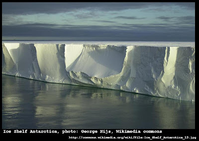
However, the hydroplate theory proposes that the earth underwent a "big roll" which was caused by the rapid thickening of the Asian continent, particularly in the region of the Himalayas, during the violent events that surrounded a single cataclysmic flood event in the ancient past. There is extensive evidence to support this "big roll" explanation, including the recent discovery of buried palm trees beneath miles of ice in Antarctica, as well as the discovery of other fossils in Antarctica and of wood there that is not fossilized but can be thawed out and used for fuel for fires!
These newly-discovered Laccognathus fossils on Ellesmere seem to be an additional piece of evidence that could support the hydroplate explanation. Further, the hydroplate theory posits that the flood event originated with a violent rupture along the line that today forms the mid-Atlantic Ridge -- such a rupture would clearly sever the territory where Laccognathus fossils have been found in Latvia and Lithuania and the territory where these more recently-reported Laccognathus fossils were found in Ellesmere.
Also, the preponderance of fossils buried in stone that was once thick wet silt (as was the case with the Laccognathus and the Tiktaalic fossils of Ellsemere) accords well with the expectations of the hydroplate theory, which argues that almost all fossils were formed by rapid burial during the catastrophic conditions surrounding that flood event -- an event in which tons of sediments were released into the floodwaters and which were later stratified by the process of liquefaction.
In fact, this previous post discusses the stratigraphy that conventional geology interprets as having been laid down successively over periods of millions of years each, but which the hydroplate theory proposes may have been laid down much more rapidly. Interestingly enough, that particular post (which was published in June of 2011, prior to the publication of the discovery of the new Ellesmere Laccognathus) discusses the coelacanth, a lobed-finned fish long declared to have lived (and died out) about 70 million years ago. The discovery in 1938 of the first modern coelacanth -- which somehow stayed the same during all those millions of years, a period of time supposedly sufficient for dinosaurs to evolve into modern chickens and other birds -- should cause some reconsideration of the conventional assumptions underlying the confident declarations of when various fossils must have lived.
In short, the hydroplate theory would argue that the Laccognathus fossils were produced by rapid burial during a flood event, following a rupture in which what is today northern Europe (where the previous Laccognathus fossils were found) and what is today northern Canada (where the more recently-discovered Laccognathus fossils were found) were separated, previously having been much closer together. In the aftermath of that event, the earth rolled such that Ellesmere Island was carried much further north, and Antarctica much further south, not by tectonic drifting over a long period of time but relatively rapidly. Some coelacanths survived this event, and today look just like their fossil brethren, even though those fossil coelacanths supposedly lived 70 million years ago.
Perhaps somewhere a modern line of the Laccognathus family survived as well, and perhaps one is lying in wait in a shallow river somewhere right now, waiting to sink its wicked fangs into some unfortunate creature.
Scientists drilling through thick ice in Wilkes Land, in East Antarctica (the part of Antarctica facing towards Australia) have reported evidence of "the growth of highly diverse, near-tropical forests characterized by
mesothermal to megathermal floral elements including palms and
Bombacoideae [a subfamily of the mallow plant or malva]" according to an article published earlier this month in the science journal Nature. Here's another description of the discovery.
The astonishing aspect of this story is that the evidence of these ancient palms and mallows and other near-tropical flora was discovered by drilling through ice sheets ranging from 1.9 miles to 2.5 miles thick!
That's quite a contrast in climates! The article published in Nature by the scientists asserts that these near-tropical forests once grew on this continent that is today covered in ice and characterized by temperatures that drop well below 100° below zero (Fahrenheit -- that's colder than Celsius, which pegs its zero at 32° Fahrenheit) because somehow the global climate back then was a "greenhouse world" and "winters were extremely mild (warmer than 10° C) and essentially frost-free despite polar darkness."
They do acknowledge that this assertion about the ancient climate may require some adjustments to "climate models."
Let's pause to think about that again. Antarctica is so cold that no month of the year has an average temperature above 0° F. It is located so far south that the tilt of the earth's axis plunges it into sunlessness for long months. It is one of the driest places on earth today, with extremely low levels of precipitation (the coastlines get only 8 inches of precipitation per year, and further inland the precipitation levels are even less, with some areas receiving essentially no precipitation for thousands of years, according to scientists). And yet scientists have discovered ancient palm trees and mallow plants under two miles of ice.
One explanation is that the world was so warm back then that Antarctica was like a tropical island, so hospitable that luxuriant forests could survive there even through sunless winter months. This appears to be the only option discussed in the recent article.
However, this certainly is not the only explanation -- nor is it a particularly good one. However, because most scientists are wedded to the tectonic theory, they are pretty much stuck with it, because explaining how Antarctica could have "drifted" to its current location poses some other problems, as discussed in previous posts on this topic (such as this one).
If all of Antarctica were on a single tectonic plate, it could perhaps have drifted from a more temperate climate. However, it would still be difficult to explain why all the palm trees and mallow plants did not decompose and rot away during such a proposed tectonic drift from the tropics (unless it was on a really fast tectonic plate that did not give the mallows time to disappear).
The hydroplate theory of Dr. Walt Brown does not have difficulty explaining this fossil discovery -- in fact, this newest finding of sub-tropical fossils under miles of Antarctic ice accords perfectly with the timeline of events proposed by the hydroplate theory.
According to that theory, which explains the geological evidence of our planet by a catastrophic mechanism rather than by the gradual mechanism favored by conventional tectonic theory, the continents slid one time in the distant past, as part of the events surrounding a global flood. The violent buckling these continents underwent at the end of that rapid drifting created huge mountains and in places great thickening of the continents.
The region of the highest mountains and greatest thickening is now the part of our planet with the highest elevations -- the Himalayas (home of Mount Everest and numerous other peaks, all the highest in the world). The sudden creation of this region caused a major roll of the entire planet, in accordance with the known principles of physics. Earth continued to rotate upon its axis, but the entire orientation of the planet was altered dramatically by this past event. The roll caused by the Himalayas moved the regions of the planet that were at the poles by as much as 35° to 45°, and at the same time it moved regions down to the Antarctic and up to the Arctic that had not previously been Arctic or Antarctic at all.
Further, the aftermath of this event was characterized by very warm oceans and much colder continents than we have today, creating the conditions for heavy precipitation, much of it falling in the form of snow and creating great sheets of ice. This was the Ice Age, which later retreated as the oceans cooled and the continents sank into the mantle in the centuries after the cataclysm. However, the very different weather patterns following the flood could explain why Antarctica, which today receives so little precipitation, has such massive ice sheets. The "Big Roll" of the planet also explains why scientists continue to find the remains of near-tropical flora in such an unlikely location as Wilkes Land.
Previous posts have discussed this "Big Roll" of our globe in greater detail (see "Earth's Big Roll" and "90° East Ridge" for example).
This most recent discovery of palm trees and mallows is by no means the only discovery of distinctively non-Antarctic remains that have been found under the ice either. Previous posts have discussed the discovery of the remains of turtles and marsupials in Antarctica, as well as the remains of Titanosaurs -- huge plant-eating dinosaurs that weighed up to 100 tons!
The hydroplate theory may strike some as extreme, but you can decide for yourself if you believe it is more likely than the conventional arguments that want you to believe that a rainforest once grew and all these near-tropical animals (and enormous dinosaurs) once cavorted upon a warm Antarctica with mild frost-free winters.
If an extreme event such as the "Big Roll" really did take place (and there is extensive evidence to support the conclusion that it did), then the hydroplate theory is not extreme at all, but rather the best way to understand the discovery of palm trees in Antarctica.
For sale: one ancient Whale Brain, fossilized (needs good home -- for a good cause). Only one other remotely like it known to exist anywhere in the world. Incredibly important, with enormous implications for geology, ancient history, and the entire historical-geological-biological paradigm. Slightly used.
Here is the rest of the story. As reported earlier this year in a story in the San Luis Obispo Tribune, this amazing fossil was found by one of two twin sisters named Pepper and Peaches, in a streambed on their family's ranch in southern San Luis Obispo County (in California, near the Pacific Coast almost exactly halfway between San Francisco and Los Angeles).
Pepper discovered the skull about nine years ago, and did not realize that it was a fossilized whale brain at first. Thinking it was a common coral fossil, it appears she used it as a doorstop for several years (see this writeup from the Beatrice Daily Sun -- Beatrice being a small town in Nebraska not far from the even smaller town of Burchard, where Pepper O'Shaughnessy lives [she found the fossil in San Luis Obispo on the family property]).
Then, in the fall of last year (2011), Pepper's sister Peaches Olson -- who still lives in San Luis Obispo County -- saw a photograph online of another fossilized whale brain which had also been found in the same county. That one was found in 1940, and it too was unknown to the world until about four years ago, when its owner Bob McGillivray of Templeton (in the northern part of San Luis Obispo County) brought it to the Natural History Museum of Los Angeles County, where paleontologists examined it and determined that it is indeed the fossilized brain of a whale. When Peaches saw that, she told her sister, who took the fossil (now located at her home in Nebraska, where it sat on the mantle when not being used to stop doors) to a local university paleontology professor.
He recommended that Pepper take it to the specialists in Los Angeles, so she put it in a sack and flew out to her home state. According to the story in the Beatrice paper, both she and the paleontologists in LA were in for a surprise:
“When I went to California with this brain I was just carrying it
in a sack and when they picked it up, they said, ‘lady, do you know
what you have here?’ and I told them I’d been using it as a door
stop for nine years,” Oshaughnessy said. “The jaws dropped at that
point. Brain coral is worth about $20 so I thought I would keep it
as a conversation piece and when they told me what it was I about
fell over.”
As senior paleontologist Howell Thomas of the Los Angeles museum explains in the same article: “It’s an amazing specimen because brains don’t fossilize because of
their soft tissue. The first thing I said when
I heard about this finding was that there’s just no way. They
brought it in, and sure enough, it’s the second of two fossil whale
brains.” In the video above, Howell Thomas can scarcely conceal his delight upon showing the fossilized whale brain to marine biologist Chuck Rennie, who has not yet seen the fossil at the beginning of the video.
Prior to the opening of the box containing the fossil brain, Dr. Rennie explains how amazing it is that the brain could have been fossilized, since the heat of a decaying marine mammal usually liquifies the brain quite rapidly -- so rapidly that dead whales today are rarely found with their brains intact for very long. In fact, as Dr. Rennie says beginning at about 0:30 in the above video, "It is not common to see a reasonably intact brain in a stranded or dead marine mammal."
As both articles cited above explain, Pepper hopes to use the fossil to raise money to fund a west coast branch of the Brucker Biofeedback Center, which uses new and innovative techniques and technologies to help those with serious neurological disabilities, including victims of spinal cord injury, stroke, brain injury, cerebral palsy, spinal bifida, encephalitis, myelitis, multiple sclerosis, spinal stenosis, and Bell's Palsy, among others. Her niece, the daughter of her twin sister Peaches Olson, was a patient at the Brucker Center (located in Miami, Florida) after a car accident nine years ago. They hope that by finding a philanthropic buyer for this extremely rare fossil, they can raise some money to "get the ball rolling" towards the creation of another Brucker Center to serve patients on the other side of the continent.
The first article cited above (from the San Luis Obispo Tribune) notes that a Tyrannosaur skeleton sold for $8.36 million in 1997, and that "There are lots of T-rex fossils, but there are only two known fossilized
whale brains, and the Olsons’ specimen is the most complete." It is hoped that the buyer would donate the fossil to a museum for further study. The brain can enable biologists and paleontologists to study differences (and similarities) between the fossil brain and the brains of modern cetaceans.
The rarity of a soft-tissue fossil such as a brain makes this fossil incredibly valuable to science (for more on rare soft-tissue artifacts, see this previous post). I sincerely hope that the family will find a generous philanthropic buyer who will donate it to science, and that funds will be raised for the worthy cause they are working on.
I also believe that this whale fossil may turn out to be even more valuable than anyone suspects right now!
Its value is certainly driven by its rarity, but it may be valuable in ways that go far beyond that, because this whale brain fossil may fit into a much larger picture involving other whale fossils, and point the way to a radical re-evaluation of geological theories and ancient history.
Back in December of 2011, I wrote about the incredible plethora of fossilized whale skeletons found in the Atacama Desert of Chile, located some 20 or 25 miles inland from the Pacific Ocean (along the path of the Pan-American Highway aka Route 5), in one of the most arid deserts in the world. I wrote then that these fossils may be best explained by the hydroplate theory of Dr. Walt Brown. In that post, I noted that other fossil whale skeletons had been found in San Diego and also in Paso Robles, California.
While geologists operating under the conventional paradigm of gradual tectonic drift are at a loss to explain the fossil whales of the Atacama, they fit with the hydroplate theory explanation quite well. That theory argues that the continents are not gently drifting at nearly constant rates for millions of years, but rather that they slid quite rapidly one time, in the events surrounding a catastrophic global flood.
Dr. Brown explains in his book (a version of which is available for reading online), the direction of motion was generally towards the Pacific basin. When the sliding continents came to a halt in accordance with the principles of physics, there was violent upheaval, buckling, crumpling, and thickening of the continents, just as there would be in the hood of a truck driven into a wall, creating the terrain features we see around us on our planet today. According to that explanation, the mountains along the Pacific edge of North and South America would have been caused by this event, and as they rose up, water would have rushed violently off, generally towards the Pacific.
At the same time that I was writing that, Dr. Brown was also writing about those amazing Atacama whale fossils in his annual Christmas letter to his readers, sent out that same month. About the same time, he added some discussion of these important fossils in his book, which can be found in the inset box entitled "A Whale of a Tale" on this page of his online version, towards the very bottom of that particular page (scroll down almost to the end).
As Dr. Brown explains:
The rapid continental drift phase ended with the compression event, the
sudden compression, crushing, and buckling of crashing hydroplates.
Mountains, such as the Andes, were pushed up within minutes. Evidence of
that compression event can be seen in Figure 49 on page 112, in thousands of similar places on earth, and in all the "Seashells on Mountaintops"that are explained on page 49.
Not only did part of the seafloor rapidly rise to become the Andes
Mountains, the overlying water rose as well. It then drained down the
rising slopes and back into the sea, sweeping with it stranded sea
creatures and drowned land animals. Larger
animals (whales, etc.) tended to become lodged in these streams, while
smaller animals (fish, etc.) were swept into and out of ponds created by
large animals damming up the flow. Sediments (especially diatomaceous
earth easily swept off the rising sea floor) filled these ponds,
fossilizing the larger animals. Mystery solved.
Now, these two fossil whale brains from San Luis Obispo County -- both found many years ago but only recently coming to widespread awareness -- may fit in to this important "whale fossil pattern" that stretches all the way from the California coast to the Atacama!
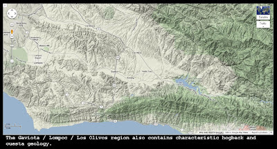
Below is a Google map of San Luis Obispo County, where these two extremely improbable (from a conventional framework) fossils were discovered, showing the terrain features using Google's "terrain" option.
ad more here: http://www.sanluisobispo.com/2012/01/07/1898625/whale-fossil-brain-san-luis-injuries.html#storylink=cpy
The county is informally divided into "North County" and "South County" based on terrain, separated by the raised "cuesta" geological feature and connected by Highway 101, which runs through a gap in the cuesta known as the "Cuesta Grade" (marked by a yellow arrow in the map below). While much of South County is nearly at sea level (or up to about 300 feet above sea level), North County is much higher, with Paso Robles sitting at about 750 feet above sea level, and the uplifted ranges in between reaching elevations of about 1,100 feet or a little higher.
You can click on the map to enlarge the image.
Note that the ranges in several places do appear to display the characteristics of a cuesta, in which the sedimentary strata have been tilted upwards, often creating long parallel ridge lines sometimes known as "hogbacks." The hogbacks of the California coast and their relationship to the hydroplate theory were discussed extensively in this previous post. There are also long hogbacks under the water just off the coast running all the way up the California coast, from San Luis Obispo County to Half Moon Bay and also north of San Francisco as well (these hogbacks create patterns that appear to be part of the bathymetry that makes the famous big waves at Mavericks break the way they do).
The first fossil whale brain, found in the 1940s and now in the possession of Mr. McGillivray (he has generously placed it on loan to the Natural History Museum of Los Angeles County for study), is from a toothed whale (perhaps a sperm whale) and was found in the North County, in the region marked with a black oval at the top of the map above. The second fossil whale brain, sometimes called the "Olson specimen," was found in South County (probably South of the city of San Luis Obispo itself).
The fact that these two incredibly rare soft-tissue fossils were found in relatively close proximity to one another seems very significant. It also appears significant that there are other fossil whale skeletons found in this same county -- as mentioned in my previous post, there is even a winery called Whalebone Winery in North County's famous wine region, very close in fact to the area where the first whale brain fossil was found, so named because of the fossil whale bones found on the property.
However, the "authorities" will probably not piece together all these pieces of evidence to come up with a compelling explanation for this mystery, because they are operating under a geological paradigm which may in fact be completely incorrect. Just as in a Sherlock Holmes or Scooby Doo mystery, that will require someone coming from "outside the box" and looking at the evidence from a different perspective.
Here is how I would piece together the clues in this case to form a possible narrative to explain the fossilized whale brains:
Just as described by Dr. Brown in the passage above regarding the fossil whales of the Atacama, the coastline where these brains were found experienced extreme forces that created rapid buckling and uplift. Along much of the California coast, this buckling created long parallel "hogbacks," and in San Luis Obispo County, the Cuesta Grade runs right through a cuesta formation that is evidence of this violent upheaval. A cuesta or hogback is formed by the sheared-off layers of tipped-up sedimentary layers -- see the drawing entitled "Monocline with hogbacks" that is the second image down in this post on hogbacks. That drawing fits the terrain at Pillar Point north of Half Moon Bay in California, but it is also applicable to the geology found in the San Luis Obispo area as well.
You can see some evidence of hogbacks in the terrain imagery of this close up of San Luis Obispo County and south, below:
Going just a bit further south along the coast from this image, there is even more evidence of exposed sedimentary layers. According to the hydroplate theory, these geological features are evidence of violent forces present at the end of the sliding of the continents, rather than evidence of very slow geological processes acting over millions of years the way the conventional theories currently teach. Note that in other posts (and in the Mathisen Corollary book itself) it is shown that the ongoing alignments of very ancient human constructions such as Stonehenge, Newgrange, the megalithic temples on Malta and the Giza Pyramids provide additional evidence that the current theories of ongoing gradual tectonic drift are incorrect.
Below is one more map showing evidence of the violent buckling experienced by this leading edge of North America (according to the hydroplate theory), geological evidence that is germane to our investigation of the cause of the fossilized skulls:
The uplifted terrain caused sediment-rich water to pour violently towards the Pacific Ocean, carrying the unfortunate sea life along with it. As Dr. Brown explains in the passage cited above, smaller fishes and sea creatures washed all the way out to the Pacific, but many large creatures including whales would not have been so successful, getting trapped along the way by their huge bulk, particularly among the maze-like patterns that are evident in the terrain of San Luis Obispo County.
In the North County, where the first fossil skull was found, there are numerous little valleys and microclimes that create a superlative wine-growing region. The soil is also very calcareous (there is in fact a winery called Calcareous not far from the location of Whalebone Winery and not far from the North County skull fossil's discovery), conducive to growing wine grapes. The whales that now make up the fossils in that area were probably trapped (along with tons of sediments) in this "washboard" of nooks and crannies. The map below is a close-up of the area where the North County skull was found in the 1940s. The San Luis Obispo Tribune story states that it was found where Halter Ranch (now a winery as well) is located today. All three points are marked on the map below (Halter Ranch, Calcareous, and Whalebone):
Looking at the map (click to enlarge, or better yet go to Google Maps and look up Paso Robles, CA and turn on the "terrain" button and explore the wine-producing area all around it), one can easily see how whales carried along with torrents of water might have gotten trapped in the maze-like terrain and been buried in the sediments that still form much of the soil there today. In fact, if you look at the terrain in the area of the arrows above (and zoom in on those areas using Google Maps for yourself), you may get the feeling that the entire area looks a bit like a fossilized brain, or many little fossilized brains!
According to this thesis, then, the whales were rapidly buried and preserved (this is a requisite for almost any fossil, by the way -- for more discussion see also this previous post). Because these whales met a rather violent death, it is possible that in some cases their bodies were torn apart in the process. In the case of these two fossils, the power of the rushing water and the violent contact with whatever terrain they ended up lodging in may have ripped open their bodies, exposing the brain and skull (the force of the water being not quite powerful enough to rip their heads clean off). As more calcareous sediments piled up over them, the limey chalky blanket preserved and fossilized the brains.
Although this thesis may sound shockingly different from anything expected under the conventional paradigm, note that the conventional paradigm has an exceedingly hard time explaining these fossils. Note also that the hydroplate theory neatly connects the whale-fossil evidence found in the Atacama as well as in San Luis Obispo, and that in fact the fossils are about the same distance from the coast in both cases, and on elevated terrain that is thick with calcareous sediments. The fact that the two brains are from different types of whales (the North County specimen being a toothed whale and the South County belonging to a baleen whale) is also consistent with the Atacama mass-whale graveyard site, which contains many whales of both types, and which may be another indication of a connection between the fossil evidence in Chile and in California.
Further, note that the geological terrain of San Luis Obispo County and surrounding regions fits the hydroplate theory explanation (with its evidence of powerful upheaval, which conventional theorists attribute to slow tectonic uplift but which the hydroplate theory attributes to the same violent circumstances that led to the death and burial of the whales). Finally, note that when Dr. Brown was developing and publishing this theory, neither the fossil whales of the Atacama nor the fossil brains of San Luis Obispo County were known -- these whale-fossil clues were found later, and they fit the theory extremely well.
In other words, it may turn out that the discovery of this second whale brain proves that the first was not just some archaeological fluke (ha ha), but a critical piece of a continent-spanning series of whale-related clues. This evidence powerfully supports the hydroplate theory, in addition to all the other varied evidence from around the globe (and indeed from around the solar system).
With all that in mind, it appears that Pepper O'Shaughnessy's doorstop is actually an invaluable find -- one that might help rewrite the history of our planet, and of the human race.
We should all wish her and the Olson family the very best in finding a buyer for this incredible artifact, and continued recovery and health for Tara Olson as well.
Please share their story as widely as you possibly can.
Their thesis proposes accelerated speciation among certain herbivorous dinosaurs in North America (duck-billed saurolophines and horned ceratopsids) caused by increased geographic isolation brought on by the rise of mountain ranges and inland sea-barriers caused by tectonic forces.
The paper's authors argue that "Late Cretaceous orogenesis commenced weather patterns" which changed "annual temperatures and rainfall patterns" that would then change "local plant composition" (6). At the same time, these changes created isolated regions as "orogenic uplift and basin segregation" prevented plants and animals from migrating along with the changes in geography and weather. They conclude that: "Modified plant communities may have acted in combination with potential geographic barriers (such as the Castelgate river / delta system and Wind River Mountains) to spur ecological barriers to herbivorous dinosaurs, preventing gene flow, and creating endemic centers of megaherbivorous dinosaur evolution."
The scientists provide fossil evidence to back up their thesis, arguing that various species evolved into other species in a certain progression that shows greater "radiation" or speciation in areas that were isolated by the tectonic uplift proposed by their geological timeline (see chart below, from page 6 of the paper).
While the paper displays a well-argued thesis with supporting evidence, it is argued within a specific geological paradigm that may in fact be completely incorrect.
There is a tremendous amount of evidence suggesting that the tectonic theory is wrong. The tectonic theory was an important step forward, because it was better than the theories that came before it, and it opened our eyes to the fact that the plates did at one time slide, but it is quite possible that instead of sliding gradually and continuously, they slid catastrophically just one time, and created most of the geology we see today during that one catastrophic event.
This radically different geological paradigm, proposed by Dr. Walt Brown and called the hydroplate theory, may be ridiculed or ignored, but so was Alfred Wegener's theory of continental drift during his lifetime. If the tectonic theory as it is understood today is incorrect, then the careful logical progression of the authors of the above paper, while not incorrect in and of itself, is built upon a flawed foundation. It is a way of explaining the evidence, but there are other ways to explain the evidence as well.
If the hydroplate theory is correct, then the mountain ranges we see today were all thrust upwards rapidly and violently, while the earth was still covered with mud-laden water. When the mountain ranges rose and water drained powerfully away, many large animals were trapped (see the discussion of the numerous fossil whales of the Atacama desert, on the Pacific side of the Andes Mountains). It is quite possible that the number and variety of species is indeed influenced by geology and mountain ranges, but that their number and prevalence is influenced by the way that water flowed off of those ranges and buried large animals, not by increased speciation caused by imagined evolutionary mechanisms in isolated areas.
This type of discussion, however, is exactly what science should be all about -- looking at the evidence and proposing different explanations that appear to fit the evidence that is available, and then arguing the merits of the various theories. Pointing out that different geological paradigms will lead to very different conclusions is not intended to be in any way derogatory -- to the contrary, I believe it is very important to acknowledge the impact of different geological theories and to argue about which ones appear to best fit the evidence.
Therefore, I applaud the work of the paper cited, even though I believe that the geological assumptions underpinning its arguments will one day be found to be in need of correction.
For more discussion of this recent paper, see this article entitled "Dinosaur boom linked to rise of Rocky Mountains," which contains some great additional quotations from the paper's authors describing their theory.
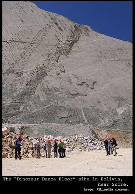
Dinosaur tracks fall into the category that archaeologists call "trace fossils," which describes any sort of preserved marks made by an ancient animal while it was still alive. Two very interesting collections of dinosaur tracks have been discovered fairly recently and both were dubbed "dinosaur dance floors" due to the number of tracks preserved there and the number of different animals which apparently made those tracks.
The photograph above is from a site discovered in 1994 in Bolivia, about 20 miles from the town of Sucre. It contains over 5,000 tracks in a bed that has been tilted upwards at a seventy-degree angle from the level. Almost three hundred different animals may be responsible for the different trace fossils here, including a singular track running for almost 1,140 feet created by a young Tyrannosaur nicknamed "Johnny Walker" by archaeologists. Here's another web page discussing the "Dinosaur Dance Floor" site in Bolivia.
More recently, geologists from the University of Utah discovered a site in northern Arizona whose impressions were previously believed to be potholes caused by weathering but which are now thought to be dinosaur tracks as well. Although some paleontologists continue to disagree that the markings are actually dinosaur tracks, this photograph from the site appears conclusive, as do some of the "tail-drag" marks which are very rarely preserved where dinosaur footprints are preserved (leading some scientists to argue that dinosaurs somehow held their mighty tails aloft when they walked).
How were dinosaur tracks preserved in what is now stone, anyway? This question is actually one that remains difficult to answer under conventional models, and one that scientists continue to work on. It is so difficult to imagine conditions that would allow such trace fossils to be preserved that scientists use the term "Goldilocks" or the "Goldilocks effect" to underscore that a multitude of factors must all be "just right" in order to lead to track preservation.
The hydroplate theory of Dr. Walt Brown provides a more comprehensive solution for the mystery of dinosaur tracks and other trace fossils, and one that can explain many of the puzzling aspects of such fossil sites quite well. He discusses dinosaur tracks in particular in the important chapter of his book dealing with the phenomenon of liquefaction, which has been examined in previous blog posts dealing with the layering found at the Grand Canyon (not far from the Arizona "dinosaur dancefloor").
Regarding the creation of fossilized dinosaur tracks, Dr. Brown explains:
Almost all trackways moved uphill, and traces
of the animal’s bodies are never found, even as fossils. Obviously,
thick sediments must have gently and quickly
blanketed the footprints to prevent their erosion—but how?
Evolutionists have difficulty explaining what protected these delicate
footprints.
How did it happen? During the early weeks of the flood, flutter
amplitudes were large enough for the crust to rise repeatedly, but
slowly, out of the flood waters. [See “Water Hammers and Flutter Produced Gigantic Waves” on page 188.]
Frightened animals—and sometimes dinosaurs—scampered uphill onto the
rising land, each leaving footprints. Minutes later, the crust again
submerged, allowing sediments falling through the thick muddy waters to
blanket and protect the prints while the rising water swept the animals’
bodies away.
This explanation describes a scene of terror, far different from the "happy scene at the water hole" described in most conventional literature discussing collections of dinosaur track fossils. It explains many puzzling items of evidence, such as the lack of dinosaur fossils in the vicinity of so many tracks made by so many different dinosaurs (which is mentioned by Utah geology and geophysics professor Marjorie Chan in this National Geographic article about the Arizona dance floor).
It would also explain the piling of sand around the edges of the tracks described by some observers, if moving water was present when the animals were trying to escape. Perhaps it would even explain the lack of tail drag marks noted at most fossil footprint sites around the world.
Dr. Brown also points out that in some dinosaur fossil track sites, including the one in northern Arizona, the animals appear to be facing in one direction and moving laterally, as if being pushed by moving water flows while they tried to walk. This web page from the State Geologist of Arizona contains a photograph of the northern Arizona site along with a drawing which appears to illustrate one set of tracks that might be interpreted as an animal walking while being forced laterally (the State Geologist of Arizona does not make this claim -- that is an interpretation that I am offering for the evidence shown on that particular page).
If Dr. Brown is correct and these tracks were not made under normal conditions (such as dinosaurs happily milling about a watering hole), then the interpretations that are often drawn from them may be incorrect (including the idea that dinosaurs typically held their tails aloft when they were walking).
In any case, the conditions at these two "dinosaur dance floors" (including the seventy-degree vertical angle of the site in Bolivia) appear to be explained quite well by the hydroplate theory of Dr. Walt Brown -- better, in fact, than by other competing explanations.