Viewing entries tagged
Antarctica

Share

Anniversary of the 1906 San Francisco earthquake


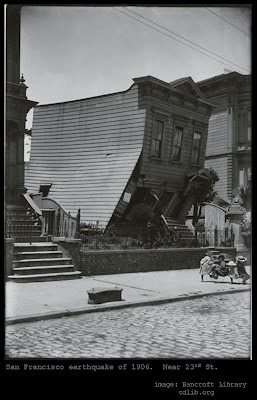
April 18 is the anniversary of the terrible San Francisco earthquake of 1906. While official records are not extremely accurate, it is now believed that over 3,000 people lost their lives in the quake and the devastating fires that raged afterwards.

The earthquake itself is estimated to have been between 7.9 and 8.25 in magnitude. Previous posts such as this one have discussed reasons to believe that the commonly cited causative mechanism for earthquakes, namely the constant drifting of tectonic plates, is incorrect.

The hydroplate theory of Dr. Walt Brown cites extensive evidence which suggests that the entire model of drifting continental plates is flawed, and that it does not do a good job of explaining evidence regarding the depths of earthquakes or the distribution of earthquake depths around two general groupings, deep and shallow.

Dr. Brown points out that "Plate tectonic theory claims that earthquakes occur when plates rub against each other, temporarily lock, and then jerk loose. If so, why are some powerful earthquakes far from plate boundaries?" Several previous posts, such as this one and this one, have discussed the question of earthquakes far from plate boundaries.

Dr. Brown also notes another important problem with the continental drift model. In a paragraph entitled "Drifting versus Shifting," he points out that the continental drift model and the hydroplate theory each posit a very different type of force to explain earthquakes. The drift model proposes a continual force, which builds up over time and eventually leads to slippage or other sudden release of energy, while the shifting model proposes a disturbance -- an unusual force that acts suddenly.

While each of these two propositions could explain the slippage along the San Andreas Fault that occurred during the 1906 earthquake, there is some evidence which seems to support the hydroplate explanation and not the tectonic explanation. Dr. Brown notes:
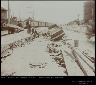
Shallow earthquakes sometimes displace the ground horizontally along a fault, as occurred along the San Andreas Fault during the great San Francisco earthquake of 1906. Western California slid northward relative to the rest of North America. The San Andreas Fault has several prominent bends, so just as two interlocking pieces of a jigsaw puzzle cannot slip very far relative to each other, neither can both sides of the curved San Andreas Fault. Furthermore, if slippage has occurred along the San Andreas Fault for eons, friction should have greatly heated the sliding surfaces. Drilling into the fault has not detected that heat.
This is an extremely important data point, and one which strikes a telling blow against the tectonic explanation. If it were the only data point that seemed to oppose the tectonic theory, it would not perhaps be so damaging, but in fact there are dozens of other powerful data points which are very damaging to the tectonic theory but which seem to support the hydroplate theory. Some of those which have been discussed in previous posts include the arc-and-cusp shape of deep ocean trenches, the unexpectedly low gravity readings scientists have measured over deep ocean trenches, and the difficulties the tectonic theory has in explaining the location of Antarctica (did it all move south on one plate, and if so then how to explain the severe sediment displacement found in the mountain ranges of Antarctica?), as well as the earthquakes far from boundaries mentioned above, and the bimodal depth distribution of earthquakes that Dr. Brown discusses in the passages linked above. The existence of Lake Vostok in Antarctica seems to pose some serious difficulties for the conventional tectonic theory as well.

Another problem with the idea of constant continental drift should be clear to anyone who has studied the rather precise alignments that still exist in ancient structures around the world, including the Giza pyramids, Stonehenge, the passage mounds of the Boyne River Valley in Ireland (such as Newgrange and others), and the ancient megalithic temples of Malta.

The 1906 San Francisco earthquake was one of the worst natural disasters in the history of the United States, with appalling loss of life. It serves as an awful reminder of the devastating power of earthquakes. We should insist on continued research and analysis into the true cause of earthquakes, and should be wary of those who insist that our current theories are beyond questioning.


Share

Share

We're busting into undisturbed Lake Vostok why?


It could happen at any moment now.

Human drillers (in this particular instance, from Russia) are poised to break through to Lake Vostok, sealed beneath miles of Antarctic ice for thousands of years (millions, according to the conventional theories).

This moment has been delayed for years, due to concerns about contaminating the pristine, undisturbed body of water, but the drilling team has finally convinced the Antarctic Treaty Secretariat to allow them to proceed, and now the probe is now only 40 feet from the buried lake.

The method selected has been designed to safeguard the lake as much as possible: this article explains that the plan calls for the mechanical bit to be replaced by a "thermal lance" which will get close enough to the lake to enable the water pressure to push water upwards towards the borehole. This water will then be allowed to freeze into ice (presumably sealing the breach again) and a sample taken of the newly-frozen ice (which will give scientists an opportunity to analyze the water of the lake (now frozen) without contaminating the lake itself.

Why on earth would we decide to disturb this pristine environment, one of the last places on earth to avoid human contamination? Read just about any article describing the operation, and you will see some variation of these two reasons offered:

1) the lake may be home to microbes that have been living in these extreme conditions for a very long time: because the lake is such a unique isolated environment, these microbes may shed light on "the earliest life" on earth, similar to microbes which may have been the ancestors of all other forms of life on earth.

2) the lake and its extreme conditions are the closest on earth to the conditions on extraterrestrial bodies Europa (a Galilean moon of Jupiter) and Enceladus (a moon of Saturn), so understanding of the life found in and around Lake Vostok could strengthen the case for extraterrestrial life on those heavenly bodies.

In other words, the main rationale for risking the contamination of this precious undisturbed lake consists of questionable Darwinist theories about life on earth and life on planets in the solar system.

What if the theory of Darwinian evolution is completely incorrect? It will certainly not be the first time that entrenched paradigms (which "everyone knows" have been "proven beyond a doubt") will turn out to be totally mistaken (see here and here, for instance).

In fact, the originator of the hydroplate theory, West Point graduate and retired Colonel Walt Brown (also a graduate of MIT) has theorized that the origin of the water spewing out of Enceladus may in fact be earth itself -- Enceladus may be composed of materials launched violently into space during the initial rupture of the earth which unleashed a global flood (see the discussion in point 8 of "Question 7" towards the bottom half of this web page from the online edition of Walt Brown's book).

In this case, it seems quite possible that the two primary reasons driving the rush to break into Lake Vostok include a mistaken theory about the history of life on earth, and a mistaken theory about the origin of life elsewhere in the solar system.

On the other hand, if the hydroplate theory proves to be correct (or much closer to the truth than any theory so far to date), then Lake Vostok is a precious time capsule preserving evidence from the time after the flood, prior to earth's "Big Roll," evidence we don't want to destroy or compromise.

It would be tragic to despoil Lake Vostok under the auspices of two theories which future generations may look back on as deeply flawed and in error.

----

update: Today, some news outlets are reporting that the team drilling at Lake Vostok has been out of radio contact for over five days, and scientists are becoming concerned for their safety. We of course join in wishing them safety even if we disagree with their mission, and are confident that they will be safe, even if their communications equipment fails. We have great confidence in the ability of human beings to survive incredibly severe ordeals: we are far more amazing than we usually even realize.


Share

Share

Titanosaurs? In Antarctica? (Moooo)


Here's a link to a recent article found in NewScientist discussing the recent confirmation of the discovery of fossils from a member of the Titanosaur branch of sauropod dinosaurs.

The family of Titanosaurs were enormous, herbivorous dinosaurs weighing up to 100 tons.

The bones of this Titanosaur were found on James Ross Island, a large island near the end of the Antarctic Peninsula (not to be confused with Ross Island, which is also in Antartica but near the McMurdo Sound, is home to Mt. Erebus, and at longitude 167o E is closer to New Zealand, while James Ross Island at longitude 57o W is much closer to the southern tip of South America). Other dinosaur bones of smaller species (runners, not massive sauropods) have been found on James Ross Island in previous years, and sauropods have been suspected based on fossil findings but until now not confirmed.

Here is a map of Antarctica showing the Antarctic Peninsula and the approximate location of James Ross Island:


Below is a closer view using Google Maps to show the location of James Ross Island where the Titanosaur fossils were found:


The discovery of the fossils of such a massive plant-eater should raise some questions, such as "How could such a massive beast get enough to eat down there in Antarctica?" At latitudes around 64o South, James Ross Island is almost on the Antarctic Circle (which runs at 66o 33' S latitude). That means that even if earth had been much warmer when this sauropod was supposedly shaking the earth with its mighty tread, there would have been precious little sunlight for half of the year where it was found.

We have already discussed some of the problems the conventional theory of tectonics has explaining the fossils found in the far north and far south, near or within the Arctic and Antarctic Circles, in this previous post.

A related post here discussed the fact that fossils of animals and plants that seem to belong to more temperate latitudes pose a dilemma for tectonics advocates, because they have been forced to invent multiple tectonic plates below Antarctica to try to explain the sheer disruption of sediment layers by uplifted mountains (which split the sediments by over 3,000 feet in places), but the fossils require an Antarctica that has drifted over time to its present extreme latitude, and putting it on a single tectonic plate is more conducive to an explanation of such a drift.

As both of those previous posts explain, the hydroplate theory of Walt Brown solves this dilemma quite elegantly, with evidence that the events surrounding a global flood caused earth to experience a single and relatively rapid "Big Roll" in the distant past.

The hydroplate theory can also explain another thorny problem with the sauropod fossils found on this remote island, which is "How did such a lumbering beast get itself to this island?" Scientists believe that members of the Titanosaur branch could possibly cross rivers, but certainly not swim out into the open ocean to cross the distance required to reach Antarctica and James Ross Island.

The hydroplate theory explains that the oceans would have been much lower relative to the continents in the centuries after the flood, as this previous post explains. This would have created land bridges not just between what are now called Siberia and Alaska but in fact between every continent and major land mass on earth, including Antarctica (the map which shows ocean depths, with shallower depths in lighter colors, presented in this previous post can help readers visualize these bridges -- even Australia would have had one, although there may have been some narrow waterways that needed to be negotiated between Australia and Asia).

Note in the map below that James Ross Island is situated very near to the proposed land bridge to Antarctica from South America. This bridge would not run directly in a straight line but curved from the southern tip of South America towards the east, before curving back west and meeting up with the Antarctic Peninsula. Nevertheless, the Titanosaurus whose bones have now been found could very well have walked to Antarctica!

Of course, based on our previous examination of how fossils are formed, and the hydroplate theory's reasonable explanation that almost all fossils on earth are the product of rapid burial in sediments during the global flood event, this sauropod probably died long before the Big Roll and the land bridges we have been discussing above, which actually makes sense based on the fact that it and the vegetation needed to feed it would not be likely to survive at the extreme latitude where James Ross Island is today.


It would appear that the recent confirmation of Titanosaur bones at James Ross Island in Antarctica supports the hydroplate theory, as do hundreds and perhaps even thousands of other pieces of evidence around the globe.


Share

Share

Black smokers and deep-sea hydrothermal vents


Recently, scientists who steered a remotely-operated vehicle (ROV) to explore deep-sea hydrothermal vents near Antarctica in 2010 published their remarkable findings in the journal of the Public Library of Science -- Biology (aka PLoS Biology).

This article from the Washington Post describes the findings in "popular media" terminology; here is the report of the actual team that was published in PLoS Biology.

Deep-sea hydrothermal vents are fascinating features and may hold important clues about the ancient history of the earth. They emit water from beneath the deep ocean floor that can be extraordinarily hot -- in some cases as hot as 464° C (over 867° F).

How can water even get that hot? Since we generally have the understanding that water boils at 100° C (or 212° F), we might think water cannot possibly get so hot, until we remember our high-school science class lesson about the fact that boiling temperature changes with pressure.

At lower pressures, water boils at lower temperatures (that's why you can get water to reach a boiling point more quickly when you go up to the mountains, and why you need a pressure suit if you take your body even higher in the atmosphere where the pressure is lower -- if the pressure gets low enough, your own body heat can cause your blood to boil for you).

On the other hand, as pressure increases, the boiling point gets higher. Down deep beneath the ocean where these deep-sea hydrothermal vents are found, the pressure is very high. Beneath the ocean floor, where the water is coming from, the pressure is even higher.

Walt Brown explains that the water that was trapped beneath the crust prior to the flood event (when most of it escaped violently, leading to events that would radically reshape the surface of our globe) was under enormous pressure. At enough pressure, that water reaches something called a "critical point" -- the point at which it will no longer boil. At or above that point, water is known as "supercritical water," incredibly hot and in a form that is something like a liquified gas:
At a pressure of one atmosphere—about 1.01 bar or 14.7 psi (pounds per square inch)—water boils at a temperature slightly above 212°F (100°C). As pressure increases, the boiling point rises. At a pressure of 3,200 psi (220.6 bars) the boiling temperature is 705°F (374°C). Above this pressure-temperature combination, called the critical point, water is supercritical and cannot boil. The initial pressure in the 10-mile-deep subterranean chamber was about 62,000 psi (4,270 bars)—far above the critical pressure. After about a century of tidal pumping, the subterranean water exceeded the critical temperature, 705°F.
This concept of supercritical water is important for understanding other clues on earth, such as the amounts of salt left by the flood, and the amount of limestone on the earth (supercritical water dissolves and holds much more of the chemicals that make up these substances than regular water can). It also helps us to understand the phenomenon of deep-sea hydrothermal vents.

Dr. Brown's hydroplate theory starts with the assumption of water trapped under the earth's surface, which became super-critical water (SCW) under great pressure. The violent escape of this water triggered a global flood. Before that initial breach, however, this supercritical water would have dissolved its way into the rock above and below the trapped water, creating a honeycomb of porous rock where it did so. According to Dr. Brown's theory, the vents deep beneath the ocean that are still spewing super-critical water today represent leftover water that remained in this porous rock at certain places on earth (there is some water remaining below the continents as well, but it is not as likely to spurt out, because there are continents on top of it, unlike that at the bottom of the oceans).

Dr. Brown explains this dissolving process, and how it may be related to the formation of deep-sea hydrothermal vents, as follows:
Quartz was one of the first minerals to dissolve. This opened up tiny grain-size pockets totaling 27% of the volume of granite. Other minerals undoubtedly also dissolved, so the chamber floor and ceiling must have looked like rigid sponges—each a few miles thick. [An interesting ancient writing touches on this. See the quote from The Book of the Cave of Treasures on page 451.] Trapped SCW that filled these tiny pockets remains today. In fact, in 2008, SCW was discovered two miles under the Atlantic floor. Scientists were shocked at finding the first naturally occurring SCW.48 This vast, steady source of superhot water, thick with dissolved minerals (and sometimes hydrocarbons49), is jetting up through the ocean floors as black smokers. [See Figure 56.]
A "black smoker" is the term often used for these vents, especially when minerals dissolved in the super-critical water precipitate out when that water vents out into the extremely cold deep ocean water, forming tall black "smokestacks."

These deep-sea vents are often the home of extremely strange and unique life forms. As the Washington Post article above explains, scientists have discovered huge six-foot worms living next to black smokers, and the image above shows a black smoker located in the Endeavor Main Thermal Area near the Juan de Fuca undersea ridge (at depths of 1200 meters to 1900 meters, or about 3900 feet to over 6200 feet) with a crowded colony of red-gilled tube worms in the foreground. The new Antarctic vents described in the articles and reports above appear to be the home of many new and previously-unknown species, including new species of kiwa crabs, barnacles, and snails (but none of the worms so common at other deep-sea vents).

The species that live near these hydrothermal vents typically eat the bacteria that feed on the chemicals that the vents spew out in the scalding-hot water -- making their food chain non-dependent on solar radiation the way ours is and the way the food chain is for all other known species on earth, according to most scientists.

The conventional explanation for these deep-sea thermal vents involves water that is somehow heated by "geothermal" heat, but although the earth's crust does contain a great amount of heat, the mechanism by which water would become heated to a super-critical temperature is not well accounted-for in the conventional explanation. This is because, in order to get to those temperatures, the water must be under tremendous pressure, and in order to get water to that tremendous pressure, the water must be in a sealed pressure chamber. Water cannot just "seep in" to an open chamber and get pressurized to the levels needed to go super-critical. Dr. Brown explains:
According to evolutionary geology, water not in a closed container seeps down against a powerful increasing pressure gradient a few miles below the ocean floor. There, magma (molten rock) heats the water to these incredible temperatures, forcing it back up through the floor. (SCW could not form by such a process, because of the two conditions highlighted in bold above. Uncontained liquid water, heated while slowly seeping downward, would expand, rise, and cool, long before it became supercritical.) Figure 55 gives a simple explanation. Besides, if the evolutionary explanation were true, the surface of the magma body would quickly cool, form a crust, and soon be unable to transfer much heat to the circulating water. (This is why people can walk over magma days after a crust has formed. The crust insulates the hot magma.) However, black smokers must have been active for many years, because large ecosystems (composed of complex life forms such as clams and giant tubeworms) have had time to become established around the base of smokers.
Thus, the bizarre world of deep-sea hydrothermal vents may be another clue that supports the hydroplate theory. It is certainly another mysterious phenomenon which the conventional theory has difficulty explaining, but which the hydroplate theory explains quite satisfactorily.

Hat tip to the "Articles Desk" section of the Graham Hancock website, where I found the link to the Washington Post article describing the new discoveries at the Antarctic deep-sea vents.

Share

Share

The South Pole, December 14, 1911


December 14 is the anniversary of the first successful expedition to reach the South Pole, the Amundsen expedition led by Norwegian explorer Roald Amundsen (1872 - 1928). This year marks the 100th anniversary of that expedition, and thus December 14, 2011 is the 100th anniversary of their arrival at the pole.

Amundsen's final successful push to reach the pole departed from their base at Framheim in the Bay of Whales (on sea ice -- Amundsen recorded its latitude as 78° 38'S) on October 19, 1911. In addition to Amundsen, his group consisted of Olav Bjaaland (1873 - 1961), Helmer Hanssen (1870 - 1956), Sverre Hassel (1876 - 1928), and Oscar Wisting (1871 - 1936).

Above is one of only two photographs the expedition is known to have taken on their successful journey. They erected a tent and the flag of Norway at the pole and left a letter inside in case they did not make it back alive.

They did successfully make it back, reaching Framheim again on January 25, 1912. Their success would not become known to the world until the expedition landed in Australia in March that year. The British Antarctic Expedition, led by Royal Navy Captain Robert F. Scott, which had been racing to the pole at the same time, arrived at Amundsen's marker over a month later, in January of 1912, to bitter disappointment. Scott's entire party perished on the return journey.

Fifty years ago, at the fiftieth anniversary of the race to the pole, in a ceremony held at the South Pole, US Navy Rear Admiral David M. Tyree (commander of the US Naval Support Force in Antarctica from 1959 to 1962) said in his remarks that "Scott and Amundsen added to the sum of man's knowledge; more important, they added immensely to the sum of man's inspiration."

The continent of Antarctica is extraordinarily important in terms of clues that it holds regarding the ancient history of the earth and mankind's distant past. Most significantly, it contains clues which point to the fact that the earth experienced a "Big Roll" following the events of a catastrophic global flood. Some of these clues have been discussed in previous blog posts, including "Antarctica" and "Lake Vostok."

The fact that Antarctica is covered with snow and ice is also a remarkable clue which provides evidence supporting the hydroplate theory of Dr. Walt Brown. Today, Antarctica is one of the most arid places on earth, with less than six and a half inches of precipitation per year over the entire continent on average (qualifying as a desert, which are generally categorized as places receiving less than ten inches of rain a year).

Antarctica probably became glaciated during the Ice Age which would have followed the global flood, when oceans were warmer and continents were higher, creating the conditions for heavy precipitation which would have been in the form of snow and ice in many latitudes of the world, including of course the Antarctic. Evidence which suggests seafaring humans may have mapped Antarctica's coastlines before it became fully glaciated is contained in various "portolan" maps drawn in the early sixteenth century AD and almost certainly based upon much more ancient maps. This evidence is discussed in the previous post entitled "The subglacial fjords of Antarctica."

Previous posts discussing the achievement of the Amundsen expedition can be found here and here. To see a dramatization of the race to the South Pole in the 1985 television drama entitled The Last Place on Earth, see here.

Share

Copernicus, Proclus, and the lost knowledge of the ancients

Share

Copernicus, Proclus, and the lost knowledge of the ancients

Yesterday, NPR aired a review of Dava Sobel's latest book, A More Perfect Heaven: How Copernicus Revolutionized the Cosmos, on the life and work of Copernicus, and the dynamics of his own struggle over his discovery that the earth revolves around the sun rather than the other way around.

The book itself, by an author who is clearly fascinated by the motions of the spheres and the turning of the earth, and who has written several acclaimed books about the interaction of human culture with these concepts including The PlanetsLongitude, and Galileo's Daughter (and who has further authored books about taking control of your health, a subject which is also close to our heart here at the Mathisen Corollary blog, as evidenced by previous posts such as this one), does acknowledge that the idea that the earth goes around the sun had been put forward before, by Aristarchus of Samos (310 BC -c.230 BC) over a thousand years earlier.

Ms Sobel explains that "Copernicus had no idea that Aristarchus of Samos had proposed much the same thing in the third century BC" -- and for all intents and purposes, it made no difference to the society in which Copernicus lived or in the human drama of his struggle in releasing his theory, or in the revolution that it eventually caused, because it is true that when Copernicus lived, virtually everybody believed that the heavens revolved around a stationary earth. It takes nothing away from his achievement to realize that mankind may have known the truth many centuries earlier and thrown that knowledge away.

The NPR examination of Ms Sobel's new book (which can be heard online here) doesn't even mention the fact that a heliocentric theory had been published in ancient times, implying that Copernicus was the first to ever come up with the idea (it also compares the current debate over global warming to the Copernican debate, implying that anyone who disagrees with "the scientific community" is akin to those who would deny that the earth goes around the sun).

But the fact that ancient authors discussed the possibility that the earth and the other planets go around the sun is not a trivial one, and should not be lightly glossed over (even though it is correctly outside the scope of Ms Sobel's examination of the personal struggle Copernicus himself faced in the early 1500s). In fact, there is substantial evidence that Aristarchus was not the first to suspect that the earth orbited the sun -- many readers will be surprised to learn that ancient authors attested that Plato (424 BC - 238 BC) may well have believed the same thing, and he was born over a hundred years before the birth of Aristarchus.

In the first appendix to his book The Sirius Mystery, which we have discussed at some length in these previous posts (herehere, and here), Robert Temple explains that Plato's Timaeus appears to hint at the possibility that the earth turns around its axis and that the planets have axes and orbits as well. He points out that the evidence suggests that Plato was not really a well-versed astronomer, and that it appears quite likely that Plato "inserted someone else's treatise into his dialogue without being completely au fait with the material." However, he notes that several ancient sources attest that late in his life, Plato changed his earlier opinion regarding the earth being at the center of the universe (among these ancient sources is Theophrastus, who lived from 371 BC to 287 BC and was the successor to Aristotle, who was the successor to Plato, and another source later on was Plutarch himself, who disagreed with Plato's conclusion).

Mr. Temple also presents compelling evidence that a much later Platonic philosopher and careful student of Plato's works, Proclus Lycaeus(AD 412 - AD 485) concluded from his careful reading of the Timaeus (and his study of other works) that the earth rotated on an axis, that the planets had orbits of their own (rather than moving as part of transparent crystal spheres), that epicycles were a clever idea but incorrect (disagreeing with the work of the earlier Plutarch, whose theories would continue to hold sway all the way up until the days of Copernicus, Galileo and Kepler), and of the possibility that the earth orbits the sun (Proclus asserted that Heracleides Ponticus, who lived from 390 BC to 310 BC had asserted such a theory, although scholars today do not agree with Proclus that Heracleides actually did so).

Mr. Temple also notes that Johannes Kepler (1571 - 1630) held Proclus in very high esteem, and wrote of the impact his work had upon him, saying:

I have recently fallen upon the hymn of Proclus the Platonic philosopher, of whom there has been much mention in the preceding books, which was composed to the Sun and filled full with venerable mysteries in the context of speculation about 'what did the ancient Pythagoreans in Aristotle mean, who used to call the centre of the world (which they referred to as the "fire" but understood by that the sun).

In fact, all of these references seem to hint that the knowledge which the early Greek philosophers and astronomers were groping for came from a far more ancient source

-- Kepler mentions "the ancient Pythagoreans" and it is an ancient tradition that Pythagoras (c. 570 BC - 495 BC) traveled to Egypt and learned from the priests of Heliopolis.

The Mathisen Corollary book explores extensive evidence that the most ancient civilizations we know -- the ancient Egyptians, Sumerians, and Babylonians -- had an understanding of the almost imperceptible phenomenon of precession, and even that they understood it to be related to the "bending," the "chopping down," or the "uprooting" of the celestial axis (which implies some understanding of the rotation of the earth).

Even further, it appears quite likely that some of the earliest ancient monuments, including both Stonehenge and the Great Pyramid, function as precise scale models of a spherical earth, with diameters and perimeters relating to the circumference of the circular equator to within 1% when multiplied by the important precessional number 432.

Further, Charles Hapgood (and later authors following his work) demonstrated that the portolan maps such as the Piri Re'is map

are almost certainly based on much more ancient knowledge of the globe, from an ancient civilization that knew much more about it than was typical even in the golden age of Greece and Plato. In his book Maps of the Ancient Sea Kings: Evidence of Advanced Civilization in the Ice Age, Mr. Hapgood explains that the circular or polar radii typical of the portolan maps were apparently based on plane geometry, causing the "parallel meridians to deviate further and further from True North the farther they were removed from the center of the map," but that "the portolan design could compensate for this" by the conscious use of "different Norths" in different parts of the map (designating one radial line as a north-south meridian in the center portion of a map, and selecting a different radial line as a north-south meridian for regions nearer the periphery of the map, with the coastlines bent around appropriately to conform to the new north-south orientation -- see footnote on page 17).

The use of such a system, in addition to the accuracy of the New World coastlines depicted in some of the portolans, and the depiction of Antarctica in more than one of the portolans, points to the possibility that they are based upon the knowledge of an ancient civilization or civilizations capable of sailing around the globe and aware of its size and shape.

If very ancient civilizations long before the time of Plato and Aristarchus knew that the earth was a globe (and crossed its oceans consciously and regularly), then it is certainly possible that they were aware that the earth went around the sun (since it is almost positive that they knew about the subtle phenomenon of precession).

All of this is important for many reasons, not least of which is the importance of shattering the smug confidence in mankind's steady and nigh inevitable upward progress which permeates NPR's discussion of the Copernican revolution. If such levels of science and learning have been erased before in human history, we should be aware of the possibility that such a catastrophe could happen again.

There are literally piles of evidence from around the world suggesting that the earliest civilizations we know of (and indeed, perhaps a lost predecessor to the earliest civilizations known to history today) were the most advanced, and that their science and knowledge were lost and almost forgotten for millennia, passed along only in secret by select groups of initiates (of whom Plato's unknown source was no doubt a member). The knowledge that the earth travels around the sun, which Copernicus and the other Renaissance astronomers would rediscover so many years later, is just another data point suggesting that almost everything we have been taught about mankind's most ancient history is wrong.

Share

Share

90° East Ridge


The Mathisen Corollary book explores the ramifications of the groundbreaking hydroplate theory of Dr. Walt Brown to the abundant evidence from human archaeology and mythology that mankind's ancient past is very different than we have been taught in school.

Dr. Brown's theory explains earth's geology through a catastrophic flood rather than through the gradual processes that were proposed in the late 1700s and began to gain ground throughout the early 1800s, and which became hardened into dogma following the rapid acceptance of Darwin's theories in the second half of the 1800s.

As we have pointed out in many previous posts, the geological and astronomical evidence supporting the hydroplate theory is overwhelming in its volume and in its diversity -- for links to previous discussions see this post or this post.

One of the aspects of Dr. Brown's theory that is extremely important for any examination of the evidence left by mankind's most ancient civilizations is the fact that his theory argues that the earth experienced a slow but massive roll in the aftermath of the violent events surrounding the catastrophic flood of antiquity.

He proposes that the continents of today slid to their current positions after the initial rupture of the earth's crust that caused the flood and that is still evidenced by the mid-Atlantic ridge which can be seen as a light-colored scar that snakes down the center of the Atlantic in the image above, echoing the contours of Europe and Africa to the east and North and South America to the west. When these continental plates ground violently to a halt, great mountain ridges were formed (just as ridges would be formed in the hood of a truck if you drove it into a brick wall).

The largest and thickest of these ridges contains the Himalayas, and the weight of this massive new clump on the side of the earth would have actually unbalanced the earth. The principles of physics would dictate that the Himalayas would have wanted to migrate towards the equator, due to the principle of centrifugal force (just as a rock spun on a string over your head will want to pull straight outwards, so too the Himalayas wanted to spin around the equator rather than around a point on the northern hemisphere well above the equator).

The force pulling the Himalayas towards the equator initiated the roll of the earth. Evidence that such a roll took place is manifest in several geological features around the world, the most dramatic of which include fossil evidence in Antarctica which reveals that the southern continent was not always at the latitudes of the south pole. We discussed this evidence and the reasons that the hydroplate theory explains it much more satisfactorily than the current plate tectonic explanations in this previous post. Similarly, the "big roll" initiated by the Himalayas pulled lands that were further south to latitudes that were much further north, including the islands now known as the Canadian Arctic Archipelago, as we discuss in this previous post.

However, there was a countervailing force which prevented the Himalayas from rolling all the way to the equator, and which moderated the roll so that it did not go as far as it otherwise would have, and that countervailing force was the equatorial bulge, as Dr. Brown explains on this page of his online version of his book (particularly in the discussion accompanying Figure 78, about 3/4ths of the way down the page).

He explains that the more the Himalayas pulled towards the equator, the more the equatorial bulge was displaced from the new line of the equator, creating a new centrifugal force vector on the bulge that wanted to pull it back towards the new equatorial region (because of the same "rock on a string pulls directly outwards" principle that we explained before as acting on the Himalayas). The spinning of the earth pulled the particles at the new equator outwards, in effect "shifting" the equatorial bulge upwards towards the new equator where it belongs.

Dr. Brown explains that each incremental shift of the bulge reduced the force vector countervailing the Himalayas, allowing them to shift towards the equator again, which then shifted the equatorial bulge out of stasis again, causing it to shift back towards the equator as well, and this process went on until stasis was reached. Geological evidence indicates that the total roll was 35°–45° of latitude.

Dr. Brown points to an important piece of additional geological evidence which supports this explanation of events, which is a long straight ridge at the bottom of the Indian Ocean known as 90° East Ridge, because of its location on the 90° East line of longitude. This ridge was formed because, as the equatorial bulge shifted incrementally back towards the equator, it actually ripped the crust, causing it to split apart as it "inched" its way along, like a pair of jeans that are too tight! Dr. Brown explains, "Magma quickly flowed up into this rip, which eventually grew 3,000 miles long and is today called Ninety East Ridge."

Because the Himalayas were further north than they are today, the equatorial bulge directly below them was shifted southward when the Himalayas tried to roll towards the point of "straight out" centrifugal force (the equator). Thus, the equatorial bulge south of the equator was trying to move back northwards (on the other side of the globe, the roll of initiated by the Himalayas would have caused the equatorial bulge to be north of the new equator and the "hoop" of this equatorial bulge on that side of the earth would have been trying to get back southwards).

Notably, Ninety East Ridge runs north-and-south and points towards the Himalayas -- powerful confirmation for this explanation of its origin. It thus would have been a rip that started at the southernmost point and moved northwards, as the equatorial bulge below the Himalayas was displaced to the south by the roll and then worked its way back northwards.

Conventional explanations for this long straight ridge (which begins at latitude 40° South and goes all the way to latitude 14° north) include a stationary "hot spot" of magma which spurted out a line of molten rock as a plate moved over it, leaving the long straight ridge we see today. Another explanation proposes that it is a remnant of a line of volcanoes marking a breakup of tectonic plates at some point in the distant past, perhaps in the Mesozoic. However, both of these theories are very dubious in light of the fact that there are numerous parallel ridges on either side of 90° East Ridge, which are explained far better by the "ripping crust" theory proposed by Dr. Brown due to the distortion created by the shifting equatorial bulge than by any explanations the tectonic adherents have put forward.

90° East Ridge can be seen in the diagram above, marked by a white arrow at its southern point. For a more detailed depiction, you can visit this beautiful 1967 National Geographic map of the Indian Ocean Floor, which allows you to hover your cursor over the map itself for a zoomed-in close-up of the artist's depiction of the geophysical bathymetry.

Dr. Brown writes that "Earth’s slow roll after the flood would have changed the paths of the Sun and stars across the sky. Attempts to measure those irregularities may have led to the construction of ancient observatories such as Stonehenge."

I agree completely with that observation, and believe that the big roll of the earth is one of the most important aspects of the hydroplate theory for its implications on the evidence left to us by the extremely advanced ancient civilization (or civilizations) that influenced other ancient cultures around the world. The evidence for such an event is extensive. The subtle clue contained in 90° East Ridge at the bottom of the Indian Ocean, pointed directly at the Himalayas, should not be overlooked.

Share