Viewing entries tagged
Maoris/New Zealand/Polynesia

Important discovery of alignments among ancient megaliths of India


In a recent issue of India's Current Science ("a fortnightly journal of research"), a team of three researchers published a study entitled "Stone alignment with solar and other sightlines in South India."

In the study, Srikumar M. Menon, Mayank N. Vahia, and Kailash Rao present evidence that a group of twenty-six ancient menhirs at a site called Nilaskal Biyana ("field with the standing stones") near Byse in Karnataka contains sightlines created by two and in some cases three stones directed to the summer solstice sunrise and sunset, and the winter solstice sunrise and sunset, as well as possibly to the setting points of several important stars.

The paper, which was submitted last April and accepted earlier this year in February 2012, concludes: "this study provides the first strong evidence of a monument with intentional solar and possible stellar alignments among Indian megaliths" (2).

India contains a wealth of megalithic stone circles, dolmens, and dramatic monoliths. This website, Megaliths of India, by Subhashis Das showcases many stunning megalithic sites in India. A statement at the top of the webpage says, "Strangely they are never promoted as heritages of India and in the process are deprived of the dignity these ancient monuments demand as true relics of our country's prehistory. . . sad."

Note that a little less than a quarter of the way down the page, there is a photograph of a sharply-inclined standing stone aligned with a prominent "V"-shaped notch in the natural visible skyline of Zulzul Hill in the background. The caption reads:
The Birbir megalithic complex comprises of an inclined obelisk (at whose front I stand), one triangle facing due east, a human shaped burial cover with a North South orientation and a Recumbent Mother Goddess Form of the Zulzul Hill at the background. Note how the tip of the menhir aligned to the "V" notch of the hill in the landscape.
This technique is strongly reminiscent of the alignment of standing stones with prominent notches in the natural skyline among the megaliths of New Zealand, categorized by the insightful Martin Doutré on his website Ancient Celtic New Zealand. Among many other possible articles from his site, this one in particular highlights the frequent use of such notches in conjunction with massive boulders to this create alignments, often with the sunrise or sunset on the solstices or equinoxes.

Note also the curious stone "lizard" or "turtle" photographed just below the Birbir menhir mentioned above, made by deliberately altering a very large rock. Interestingly enough, the final two photographs at the bottom of this article by Martin
Doutré shows another example of the same kind of large rock sculpture. In the case of the giant lizard cited by Subhashis Das in India, the head faces due east (towards the sunrise on the equinoxes). Similarly, the face at Whangape in New Zealand, which Mr. Doutré believes represents the god Tangaroa, also faces to the east.

Further examination of the many megalithic sites in India might turn up even more remarkable similarities to those in New Zealand. This is an extremely important line of inquiry, as these connections (as well as parallels to sites in Europe which Mr.
Doutré details on his site) strongly suggest the presence of inhabitants in the islands of Aotearoa long before the arrival of the Polynesian Maori in the thirteenth century, inhabitants connected to other ancient megalith-constructing cultures around the globe (or perhaps members of a single megalith-constructing culture). The evidence presented by the skull of the "Ruamahanga Woman" suggests the same possibility.

It is also likely that additional rigorous examination of other stone circles and clusters of menhirs in India will reveal further solar and stellar alignments, as well as (most likely) encoded precessional numbers in their dimensions (Mr.
Doutré points out many of these in his writings, and I note several additional examples of precessional numbers encoded in dimensions of stone circles and other sites -- some of which I believe have not previously been noted -- in my own book).

Srikumar Menon, Mayank Vahia, and Kailash Rao are to be commended for their work in advancing the understanding of the solar and possibly stellar alignments in ancient stone sites in India. We should all wish them well in their future endeavors and hope that they continue to discover more of these important clues to the ancient past.

The unbelievable bathymetry of Mavericks


The window for the Mavericks surf contest is open through the end of March, and at any time the selected contestants can be given 24 hours to head to California for the big-wave competition.

The contest has only been held seven times since 1999. The surf spot has only been known to the general public since 1990, after a photograph taken by a friend of Mavericks pioneer Jeff Clark (who first surfed it alone as a teenager in 1975) was published in Surfer magazine.

It is one of the largest and heaviest waves in the world (which makes the fact that Jeff Clark paddled a half-mile out to sea to surf it alone for years all the more impressive).

Surfline, itself a pioneer in the world of predicting surf, has an outstanding special feature presentation on the mechanics of Mavericks and the interaction of water and geology that produces its monster waves. It was produced and written by the late Sean Collins, the founder of Surfline, who was single-handedly responsible for changing the way surfers around the world check conditions before heading to the ocean, and published on November 16, 2011 -- only a month before he left this life at the age of 59.

The thirty-page analysis features beautiful aerial photographs and especially underwater bathymetry images showing the unique underwater terrain that channels wave energy from the largest northwest Pacific storms into the lineup at Mavericks. The word "bathymetry" (Greek for "the measurement of the deep") refers to the same science as topography, but underwater. Slide 8 of the Surfline analysis of Mavericks explains that:
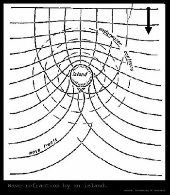
Swells approaching Maverick's from the North Pacific will first pass over the continental shelf, and the distribution of swell energy along the coast will be determined by swell interaction with the topograph of the ocean floor (bathymetry). Swell energy will always turn towards shallower water (refraction), and swell direction and swell period will be contributing factors of how much the swell will refract.
Willard Bascom (1916 - 2000), a pioneering oceanographer and scientist and author of the excellent Waves and Beaches: the dynamics of the ocean surface (1964), whom we have met before in this previous post, explains refraction in that book by saying:
Refraction simply means bending. As waves move into shoaling water the friction of the bottom causes them to slow down, and those in shallowest water move the slowest. Since different segments of the wave front are traveling in different depths of water, the crests bend and wave direction constantly changes. Thus the wave fronts tend to become roughly parallel to the underwater contours. 70-71.
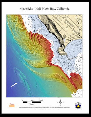
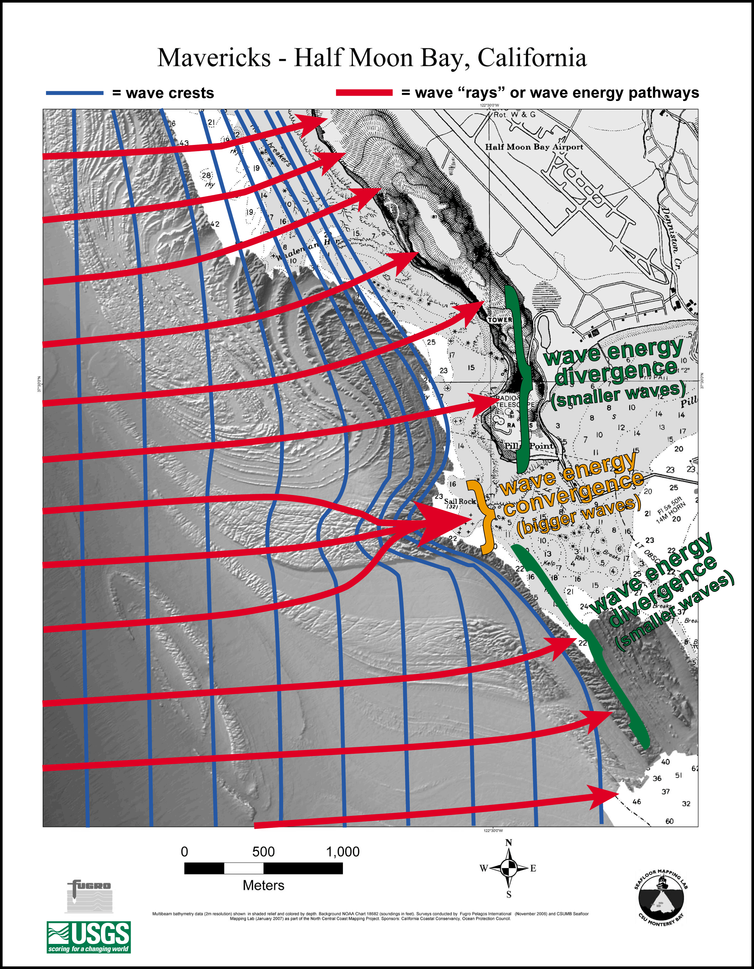
Underwater bathymetry imagery released in 2007 from the USGS and Cal State Monterey Bay revealed an amazing complex of dramatically curving reefs that channel the wave energy into the patch of ocean located off of Pillar Point (at the northern boundary of Half Moon Bay) where Mavericks breaks when the swell energy is powerful enough and the swell direction is right.

Slide 14 of Sean Collins' Surfline presentation of the Mechanics of Mavericks shows the critical portion of this underwater reef complex. The text on that slide reads:
The unique bathymetry extending about a mile offshore is the secret to the big surf at Maverick's. Recent side-scan sonar surveys by the USGS and the Seafloor Mapping Lab at California State University at Monterey Bay have revealed a very interesting swirling pattern of shallow reef that extends westward off Pillar Point. These swirling grooves in the reef off Pillar Point act like a huge magnifying glass to merge and focus extra wave energy from adjacent deeper water toward the shallower reef. The unique patterns in the ocean floor were created by long-term erosion and historic seismic activity of the local San Gregorio Fault system. Another possible cause is huge icebergs during the last Ice Age that may have helped to grind out these grooves -- a similar phenomenon that also occurred on the Hudson Shelf near New York.
The fantastic curving patterns can be seen in the NOAA/USGS imagery from this website shown in the diagram below. You can see how the deep channels on either side of the Mavericks lineup create refraction that cause waves to bend towards the shallower ridge in between the channels, focusing the wave energy.


The origin of these graceful curving reefs, like other geological features on earth, invites various explanations. Like a popular mystery story (such as the stories of Sherlock Holmes, or Scooby Doo and the gang), there are explanations which generally fit into the popular assumptions and preconceptions of the powers that be, but these explanations may or may not stand up to scrutiny. The conventional explanations will generally involve tectonic forces, such as the idea that they were caused by "long-term erosion or historic seismic activity of the San Gregorio Fault system" cited above.

A more detailed example of a conventional explanation for such extreme curving geological features can be found in the Highly Allocthonous website of geologist Chris Rowan, where such plunging folds are explained as a "tale of orogenies past," in which tectonic forces lift parallel layers upwards (causing them to bend), and then other forces cause the fold axis to become tilted to some degree. When the tilted bent layers are sheared off, the folded layers present dramatic hairpin bends that represent the top of the uplifted layers. Mr. Rowan entitles his post "12 folds a-plunging" and provides numerous photographs of examples from around the world (all of them above the current ocean surface).

This blog post from professional geologist Michael Welland (author of Sand: the Never-ending Story, 2010) discusses the extreme curved reefs off the California cost near Half Moon Bay and links to the Highly Allocthonous post about "plunging folds" as a likely explanation for the bathymetry that gives rise to the waves of Mavericks. While the Highly Allocthonous post does not directly mention the reefs off of Pillar Point, the other examples it offers of "plunging folds" certainly makes it appropriate for Mr. Welland to argue that the mechanism described for the curving patterns in "12 folds a-plunging" are the same forces that created the bathymetry at Mavericks, and Mr. Welland concludes that the Pillar Point reefs are "clearly 'folds a-plunging' in the sea-floor off San Mateo County."

There are some significant details, however, which call into question this explanation for the origin of the severe curving reefs near Half Moon Bay. First, there is the question of the distinctive reef composed of concentric circles indicated by the white arrow in the imagery from CSU Monterey Bay below (this is the same imagery as that in the image above, but colored to indicate depth, with red being shallower and blue deeper water depths, and yellow indicating depths in between blue and red):


It is difficult to imagine a scenario in which the concentric circles of the reef indicated by the arrow could have been created by uplifting of layers which were later tilted and sheared off.

In fact, the more one considers that explanation, the less satisfactory it appears in light of the reef patterns depicted in the sea-floor imagery. Note, for example, that the curves are clearly further apart at the point of greatest "hairpin turns" rather than closer together as we might expect if they were actually caused by tectonic uplifting.

Further, a close examination of the topography will reveal that the terrain in question is deeply scored and jumbled, and that it appears that wide bands have been "planed out" in this deeply scored terrain to create the graceful curves, but that some of the scoring lines clearly continue on the "other side" of the "planed out" bands.


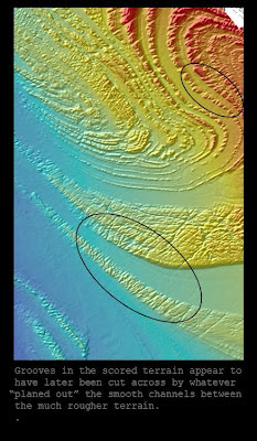
For instance, in the image above, the reader can examine grooves and scoring inside each of the circled areas which appear to have once belonged to a continuous piece of land which was later divided by some force that carved out a deep and smooth channel right down the middle. Not only are these channels significant to surfers at Mavericks (since they act to bend the wave energy towards the central ridge), but they are also important clues to the mysterious underwater terrain off the California coast.

The fact that something appears to have cut across the existing terrain and left deep grooves like this indicates flow of something -- the most likely suspects being liquid or viscid flows, either lava, glacial ice, or water. In each case, it seems clear that the terrain was not under the surface of the ocean when the lava, ice, or water carved these channels. The curving patterns are certainly indicative of flowing liquid or viscid forces as well*.

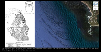
The image below from Google maps shows that the graceful curving reefs that create the Mavericks break are part of a larger patch of underwater ridges that stretch north of Pillar Point towards Montara and south into Half Moon Bay itself, but which are most extreme in the area of the Mavericks break.


The darker area contains swirling patterns as well as "feathered" ridges that seem to end in a series of parallel points, resembling quite remarkably the patterns of the sacred moko of the Maori of Aotearoa (New Zealand).


The reader can click on the image to zoom in and see the details, or even better to visit Google and conduct a search on their maps for "Half Moon Bay, California" -- selecting the "satellite" imagery view rather than the "map" imagery view in the upper-right corner of the map will bring up the sea-floor images seen above.

Cruising along the Google Maps imagery up and down the California coast will show that the extended dark rough patch near Mavericks that resembles a moko in its swirling pattern may be more extreme than those found elsewhere, but that it is by no means alone. Other such patterns rise up out of the otherwise much smoother continental shelf at various points, including further north near Bolinas (also near a significant headland like Pillar Point accompanied by a wide bay) and further south near Morro Rock (again, a prominent headland and one which in this case features an obvious volcanic extrusion). See the images below.


In the image above of the long dark scored reefs off the coastline near Bolinas, California, note the same hairpin curves and feathering found at Mavericks, and also note the very distinctive concentric circle pattern which is even more pronounced than the concentric ring pattern pointed out at Mavericks in the images above.


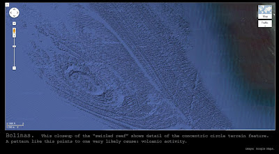
The detail of the Bolinas pattern reveals very clear evidence that these "moko" patterns that seem to rise up at certain points along the California coast may be indications of volcanic activity in the ancient past. The concentric circles of the Bolinas "rough patch" form a complete ring (unlike those off of Pillar Point / Mavericks), and the USGS / CSU Monterey Bay imagery appears to indicate steeply beveled sides to the ring, giving it a very clear crater-like appearance.

Moreover, the deeply scored and darker sea-floor both here and at Half Moon Bay / Mavericks seems to indicate volcanic flow. The image below of another such "rough patch" off the coastline just south of Morro Rock (further south along the California Coast from Half Moon Bay, south of Monterey and Carmel and Big Sur) reinforces this conclusion:


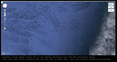
This kind of "washboard" terrain is very characteristic of ancient volcanic action, and is reminiscent of the terrain around Fort Irwin and the Mojave Desert that was discussed in this previous blog post. Note that again we find a volcanic-looking rough patch protruding from the otherwise smoother seafloor in the vicinity of a prominent headland -- Morro Rock sticks out into the Pacific in much the same way that Pillar Point does. It would be redundant to include an image of it here, but another such patch can be observed at Point Año Nuevo not far south of Half Moon Bay.

The interesting thing about these mysterious patches of heavily scored volcanic-looking ground is that they are surrounded by much smoother seafloor. In fact, looking at them for a long time will give the distinct impression that these rough patches themselves are partially filled up with the same thick silt and sand that blankets most of the adjacent seafloor. Let's return to the imagery around the Mavericks surf break and see.


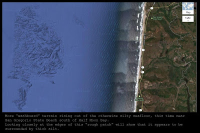
Just south of Half Moon Bay, at San Gregorio State Beach (where highway 84 intersects the Pacific Coast Highway or Highway 1) there is another small "rough patch" that clearly appears to be surrounded by silt. These patches are starting to give the impression that the entire ocean floor off the Northern California coast is really rough and washboard-like, but most of it is drowned in silt.


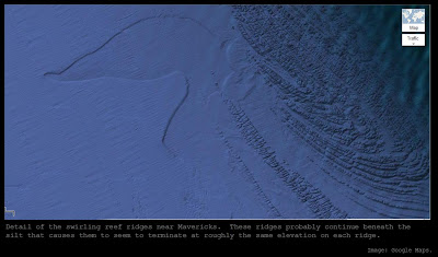
A close-up look at the swirling ridges that lead in towards Mavericks gives the same impression: it appears that the long "feathered" ridges disappear into a deep layer of silt. In other words, these ridges probably continue on below the surface that we can see: they were formed first and then buried later in silt.

A closer examination of the concentric terrain feature near Mavericks will reveal the same thing: it is probably a crater very much like the one shown above at Bolinas, but since it is deeper and more deeply buried in silt, only the upper edges of the lip of the crater can be seen, and these do not form a complete circle above the silt as the crater at Bolinas does (the Pillar Point crater is probably a complete circle, but some of its lip is below the level of the silt that flowed in later).

What could explain these amazing terrain features? The conventional explanations are quite inadequate. The hydroplate theory of Dr. Walt Brown, however, provides a scenario which appears to fit the evidence quite satisfactorily.

We have already seen in previous posts that Dr. Brown's theory envisions the continents sliding away from the initial rupture (and the rapidly rising Atlantic floor, which sprang upwards after the escaping floodwaters removed enough sediment) and towards the newly formed Pacific Basin (which buckled downwards in compensation for the upward-springing Atlantic floor, "sucked" towards the Atlantic on the other side of the globe as if the underside of the Pacific floor were connected through the earth by long cables to the underside of the Atlantic).

The forward edge of the Americas would have experienced tremendous friction, enough to create heat sufficient to melt granite and produce massive amounts of magma, which later spilled out as immense lava flows (the Columbian basalts of Washington and the volcanoes of the Mojave area are two examples of evidence of this activity). Such friction and melting could explain the volcanic-looking deeply scored "washboard" terrain that we see in places along the front-edge of the drifting continent (the California coast and the continental shelf).

As the continents slid, they buckled and thickened. Later, when the continents finally ground to a halt, the floodwaters poured off of them towards the ocean basins, dumping massive amounts of sediments into the ocean basins. The waters pouring off the continents carved immense canyons as they cascaded over the edges of the continental shelves: the Monterey Canyon that was discussed in this previous blog post is one such canyon, as are the canyons of the Ganges Fan and the Indus Fan and the canyons found under the sea at the mouths of some of the largest rivers in the world such as the Amazon and the Hudson.

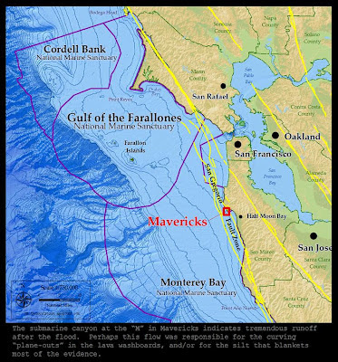
At that time, when those canyons were formed, the sea level was much lower than it is today (that's why those canyons could be carved by rushing water -- today they could not be carved because they are under the ocean). Note that another mighty submarine canyon yawns below the lip of the continental shelf just west of Mavericks and Half Moon Bay as well. Look just left of the large red letter "M" in the word "Mavericks" in the image below from this NOAA website about National Marine Sanctuaries in the United States.


The sediment-rich waters flowing off of the continent may well have blanketed the washboard features so deeply that they only protrude in certain places along the California coast. It seems that at places where a large promontory (such as Morro Rock, or Pillar Point) shielded some of the silt flow, less sediments were deposited and some of the fingers of volcanic reef could poke through the silt. This silt likely hardened into sedimentary rock over the centuries before the sea levels rose to cover the continental shelves (the hydroplate theory explains that the continents were much higher relative to the seas immediately after the flood for some hundreds of years, before their great weight caused them to sink down and the ocean floors to rise).

The graceful curving patterns could have been caused by lava flow from the original lava activity that created the rough volcanic terrain, but it is much more likely that they were planed-out later while the continental shelves were still above sea level (based on the fact that some of the original grooves and scoring are interrupted by the broad channels that must have been scooped-out later).

These channels may have been carved out by glaciers which covered North America during the Ice Age that was caused by the temporarily higher continents and lower warmer seas (the warm oceans producing much more precipitation, which fell as snow and ice over the colder higher land masses). We know that glaciers reached these latitudes in California, as Yosemite Valley further inland is an obvious product of glacial carving.

An astute reader might wonder how the silt filled these glacial channels, if the silt was deposited by waters flowing off the continents right after the flood and before the Ice Age. It is possible that waters were trapped in the Great Central Valley of California long after the initial flood, later breaching and rushing out to the Pacific (just as other trapped waters later breached and carved the Grand Canyon, depositing tons of sediments in the Gulf of Mexico in the process, as Walt Brown explains in his book, which contains an entire chapter on the Grand Canyon).

The exact mechanism that carved the graceful channels in the original deeply-scored washboard is not certain at this time, but it appears likely to have been either glacial ice or sediment-rich water, and possibly later lava flows although this mechanism appears less likely*. The bottom line is that the mechanisms proposed by conventional geology appear quite inadequate, while there are several options which fit the general outline of the hydroplate theory. Note that the hydroplate theory was around long before the undersea images became available in 2007.

Thus, the incredible undersea terrain that produces the mighty waves of Mavericks appears to be yet another piece of geologic evidence that is very difficult to explain using conventional geologic theory, but which fits rather nicely within the predictions of the hydroplate theory.

The only question is, did the Polynesians (who gave the world surfing in the first place) somehow know about the distinctive undersea swirls that produce the gigantic waves at Mavericks, and incorporate these patterns into their tattooing? If so, perhaps they knew about this "undiscovered" surf break centuries before it became known again in the 1990s! But that is a mystery for another day.


* Note: since publishing this post, I have come to believe that hogbacks are the most likely explanation for these dramatic underwater features -- see this post, published 02/16/2012.

Tutankhamun's DNA


In the previous post, we pointed out that the discovery of the tomb of Tutankhamun was significant for many reasons, especially for the largely intact nature of the tomb. Although it had apparently been robbed twice in antiquity (probably within a few months of Tutankhamun's burial), the tomb's entrance was later covered by huts built to house the workers building the tomb of Rameses VI almost two centuries later and forgotten.

The ancient robbers were apparently unable to penetrate the nested oak shrines housing the sarcophagi of the king, or else did not have time or the inclination to do so, and thus Tutankhamun remains the only pharaoh whose mummy was found in modern times where it was originally laid to rest by the ancients.

As a consequence, his tomb provides a remarkable window into ancient Egypt. Some of the clues that are preserved in Tut's tomb may turn out to be extremely important to arguments that mankind's ancient past differs from what is taught today in conventional history books.

For example, the magnificent golden funerary mask that was found over the head of the mummy itself -- by far the most famous artifact from the tomb of Tutankhamun, and one that might not have survived had the tomb not been lost to history for over 3,000 years -- appears to contain symbolism linking it to the mokos or facial tattoos of the Maori of New Zealand, according to the analysis of Martin Doutré (discussed in this previous post).

If Mr.
Doutré's analysis is correct -- and I believe it is very convincing -- then there must have been some ancient contact across the oceans at dates far earlier than conventional history allows. It could be that the Egyptians themselves traversed the oceans (there is other evidence that may support this theory, such as possible Egyptian religious elements in the Maori haka, discussed in this post, as well as other epigraphical evidence that has been found in places such as North America), or that other cultures did so and then traded with the Egyptians (such as the Phoenicians, famous in antiquity for their maritime abilities, or the Anatolians and the Libyans, who also may have been accomplished seafarers), or that cultures directly descended from or heavily influenced by the Egyptians did so.

Recently, new evidence from Tutankhamun's tomb has emerged which -- if true -- could shed some more light on this fascinating topic (and further undermine the conventional history books). Genetic testing has been done on the mummy of Tutankhamun in order to gain greater clarity on his patrimony. Egyptologists have long suspected that Tutankhamun may have been the son of the famous pharaoh Akhenaten, who established the worship of the Aten instead of the traditional worship of Amon-Ra and the other deities during his reign (Tutankhamun appears to have been called Tutankhaten before changing his name -- some artifacts in the tomb bear evidence of the change, and others appear to have been missed altogether and still read Tutankhaten).

Now, through genetic testing, scientists can examine Y-chromosomal evidence that provides confirmation of shared paternal lineage. As this series of videos from the Discovery channel indicate, the tests establish a clear match between Tutankhamun, Akhenaten, and Amenhotep III. It is well-established that Amenhotep III was Akhenaten's father (Akhenaten's name was Amenhotep IV before he changed it). The new tests appear to confirm that Tutankhamun was either Akhenaten's son or his younger brother (Amenhotep can either be Tutankhamun's father or grandfather).

Following on this Discovery series, Swiss genetic research company iGENEA recently announced that they had determined the haplotype of Tutankhamun's Y-chromosome DNA and that "
Tutankhamun belongs to the haplogroup R1b1a2, which more than 50% of all men in Western Europe belong to." Here is a related story from Reuters about the announcement.

There have been some significant arguments against iGENEA's conclusion, including the allegation that iGENEA has made sensational announcements before, possibly in order to increase sales of their genetic tests (as you can see from the link above, the Tutankhamun announcement came with a request that men have their DNA tested by iGENEA and if they match the DNA of the mummy, they will get a refund of the testing costs, which run from129 to399).

Other critics have been quick to throw down the race card, stating that the only people interested in Tutankhamun's haplotype are probably either "Nordicists" or "Afrocentrists." While it is of course true that there are those who try to elevate their "race" over others (race being a Darwinian fiction to begin with, as we have discussed previously), and while it is true that white racists and black racists may both be found trying to claim the accomplishments of ancient Egypt as proof of some form of racial superiority or identity, it does not follow that any DNA match between Tutankhamun's haplotype and that of western Europeans is the product of racist bias or propaganda.

A more basic criticism of iGENEA's claim is that they didn't have access to the DNA at all before they made their analysis. Although the DNA test which matched Tutankhamun to Akhenaten and Amenhotep III was done with the actual tissue of the mummy, iGENEA admits that they reconstructed the haplotype by watching the Discovery channel episode, where a computer screen shows the data that they needed to do their analysis -- the DNA itself has "been locked away" and is not available to other researchers.

One of the geneticists who was part of the team that did the original work on the DNA, Carsten Pusch, has denounced iGENEA's conclusion, as seen in this article from Live Science. That article admits that "
Pusch and his colleagues published part of their results, though not the Y-chromosome DNA, in the Journal of the American Medical Association (JAMA) in 2010."

The unanswered question not raised in that article (nor the others denouncing iGENEA) is the question of why the full Y-chromosome DNA results were not published and are apparently being kept secret? If iGENEA is wrong about what they deduce from the computer screen shown in the Discovery channel documentary, then what has anyone got to hide? Why not get the results out in the open?

Whether or not Tutankhamun's DNA actually shows commonality with the haplotype in question is not really conclusive one way or the other. If iGENEA's claims are correct, then this commonality of haplotype in one ancient Egyptian family of pharaohs is only one piece of evidence, and a solid case needs more evidence than a single clue. However, it may turn out to be an important clue.

Furthermore, there is other evidence in addition to this rather recent development which points to a very different timeline of ancient history -- and a complete reassessment of the scientific capabilities of the ancients -- as many other "alternative" authors and historians have alleged, as we have discussed numerous times in previous posts, and as discussed in greater depth in the Mathisen Corollary book.

It may be that Tutankhamun's family tree -- already quite interesting -- is more extensive than anyone suspected.


Happy Thanksgiving -- please pass the kumara!


Thanksgiving in the United States is a beloved and special holiday, on which we pause each year and gather with family and loved ones to consider all the many blessings we should be thankful for in our lives.

The traditional Thanksgiving feast contains elements stretching back to the first Thanksgiving in 1621, in which the Plymouth Bay colonists gave thanks for their first successful harvest, and were joined by Massasoit and members of the Wampanoag people who had taught them how to cultivate beans, squash and corn and who brought two deer and other food for the occasion.

One Thanksgiving staple that is part of nearly everyone's annual feast will be a dish made from the sweet potato, a traditional American cultivar unknown in the Old World prior to contact with the Americas which was known to the native peoples and an important dietary staple.

The sweet potato is also an intriguing clue in the question of whether Polynesia was originally settled from the east (the Americas) or from the west (through Melanesia or Micronesia), and may argue against an eastward expansion into Polynesia and for a westward expansion from the Americas, as Thor Heyerdahl has argued, and which is a theory for which there appears to be abundant evidence, in spite of the disdain with which this suggestion is regarded among conventional scholars today who flatly state that the question has been settled in favor of an eastward expansion from Asia.

In a 1946 essay entitled "How did the Sweet Potato reach Oceania?" anthropologist James Hornell explains the dilemma: "Botanists are agreed that America is the area within which the sweet potato was first brought under cultivation. One consequence arising from this conclusion is that the problem of the means whereby it became diffused throughout the island world of Oceania has given rise to great controversy" (cited in Heyerdahl's American Indians in the Pacific, 428).

Because the Polynesians widely cultivate the sweet potato from Easter Island to Hawaii to New Zealand and all places in between, and because it could not have come from Asia originally, ethnologists have long debated how the sweet potato became such an important part of the Polynesian diet and culture.

At first, many analysts who refused to consider the possibility that Polynesia was settled from the east (from the Americas) speculated that the first European vessels (primarily Spanish) must have brought the sweet potato across the thousands of miles of the Pacific from South America to the islands of Oceania.

The problems with this theory are quite stark. Chief among them is the extensive historical evidence, documented by R. B. Dixon in 1932, that the most remote and long-isolated Polynesian islands had extensive and ancient sweet potato plantations when they were first discovered by European voyagers (in "The Problem of the Sweet Potato in Polynesia," cited in Heyerdahl 430). He also points out that when Jacob Rogoveen became the first modern European to land on Easter Island / Rapa Nui in 1722, he and his men described "the sweet potato as abundant, grown in large plantations, and one of the mainstays of the native food" (ibid). Further, traditional history in both Hawaii and New Zealand point to cultivation in those islands by AD 1250 in Hawaii and AD 1350 in New Zealand, at the latest (Heyerdahl 431).

Another possibility that has been mentioned is the idea that a sweet potato somehow floated on its own from South America across the thousands of miles of ocean to the islands of the Pacific, and then was planted and spread to the rest of Polynesia. This speculative theory is difficult to maintain in light of the fact that the sweet potato propagates from its tubers as opposed to seeds that can be born safely along the ocean currents -- a sweet potato would not survive well on the open sea, especially because of the salt content of the ocean. Further, since the tubers grow underground, they are unlikely to simply fall into the sea like a regular seed might. Because new plants can really only be started from a tuber or a clipping, it is far more likely that sweet potatoes were deliberately carried across the oceans on ships and planted.

Nevertheless, Thor Heyerdahl records the suggestion put forward by some botanists that perhaps "a Peruvian sweet-potato might have been caught in the roots between a falling tree near the Pacific shore, and drifted with the tree" until washing up on a Pacific island thousands of miles away, to be planted in the ground by amazed islanders who had never seen one before but knew to bury it in order to get more.

Heyerdahl, however, points to a problem which puts to rest this wildly speculative, and that is the fact that "the sweet-potato was known as Cumar (Kumar) in the Quechua-dialect of Ecuador, whereas it was known in Polynesia as Kumara, with sundry dialectical variations" (429). Even if a tree managed to fall into the ocean with a sweet potato serendipitously lodged in its roots, this could not explain the fact that when it arrived in Hawaii or other points east, the inhabitants "recognized it by its original South American name" (Heyerdahl 429).

The sweet potato is known as the Cumara, Umar', Kumal, Umala, and Kuala in the Quechua language of the Andes and in variations found in other parts of South and Central America. The fact that the sweet potato is known to this day as the kumara in New Zealand (as well as in Easter Island, the Tuamotus, and Mangareva), and by variations such as Kuma'a in the Marquesas, Umara in Tahiti, Uala in Hawaii, Uara in Mangaia, Kuara in Rarotonga, Kumala in Tonga and Futuna, and 'Umala in Samoa argues strongly for actual ancient contact between the seafarers of Polynesia and the Inca and other people of South America (Heyerdahl 430).

Many today accept that the Polynesians could have journeyed to the Americas and brought the sweet potato back with them, while still originating in Asia. This theory is certainly a possibility, as it is no exaggeration to award the peoples of the Pacific with the title of "the greatest navigators our globe has ever seen."

However, Heyerdahl puts forward some powerful arguments for the alternate possibility, which is that the sweet potato was brought out of the Americas by the original settlers of the islands of the Pacific, who came from the east and sailed to the west (a possibility that in no way diminishes the argument that these seafarers became the greatest navigators our globe has ever seen, although some today seem to believe that a westward migration somehow robs the Polynesians of their seafaring accomplishments for some reason, and who call Heyerdahl's proposition "the ultimate insult" -- see the discussion in this previous post).

For one thing, Heyerdahl points out that the sweet potato's importance and cultivation was greatest in the most remote of the islands of Polynesia -- those on the very "points of the triangle" that define the vast region of the Polynesian culture: Hawaii, Easter Island, and New Zealand (431). Some scholars have concluded from this fact that this is just the sort of distribution that would be most likely if the kumara "had been brought during the initial period of voyaging" that brought the first settlers to the islands (431).

He also points out that there are no Polynesian traditions relating a voyage to the Americas in which the new foodplant was discovered and brought back to Polynesia. In fact, he points out that "there are a vast quantity of traditions to the contrary" (traditions which state that the important food crop came from the ancient ancestral lands -- Heyerdahl 432). Heyerdahl also points out analysis from early records that relate the are over sixty varieties of sweet potato in Hawaii (arguing that it has been grown there for long centuries) and Captain Cook's records of ancient plantations and "vestiges of former plantations on the hills" (citing an account from 1778).

In short, the sweet potato (or kumara) is an important piece of evidence in the examination of the origins of the people of the Pacific islands. Alongside other evidence (such as the items discussed in this previous post), it appears to enhance the possibility that the islands of the Pacific were settled from the Americas and towards the west, rather than from Asia and then towards the east. This possibility may help clear up some of the evidence suggesting a distant connection to some aspects of ancient Egypt in the culture of Polynesia (see for instance this previous post, this previous post, and this previous post).

So, while you are enjoying your sweet potato casserole this year at Thanksgiving, give some thought to the significance of this far-ranging tuber.

Happy Thanksgiving to all the Mathisen Corollary readers around the world!

The Ka Mate haka


It's time for the Rugby World Cup championship match, which will take place on Sunday, October 23, at 9 pm in New Zealand (1 am California time) between the All-Blacks of New Zealand and the national team of France, sometimes referred to as les bleus. The World Cup is only held every four years, and this year's matchup finds the same two nations competing as those that met in the inaugural Rugby World Cup in 1987.

The All-Blacks will of course perform their famous haka immediately before the match. The haka is a traditional Maori ritual dance with chanting, conveying the ultimate resolve in the face of a challenger or enemy. It features ferocious facial expressions including opening the eyes wide and sticking out the tongue, as well as deep stances, the slapping of the thighs and chest, and stamping the feet.

This website cites a quotation from Alan Armstrong's 1964 book Maori Games and Hakas: Instructions, Words and Actions describing the haka in this way:
The Haka is a composition played by many instruments. Hands, feet, legs, body, voice, tongue, and eyes all play their part in blending together to convey in their fullness the challenge, welcome, exultation, defiance or contempt of the words. It is disciplined, yet emotional.
In an article on his website Ancient Celtic New Zealand, Martin Doutré makes some extremely interesting observations about the similarities between the stylized facial expressions and deep stances of the haka and the Egyptian god Bes, a lion-headed god who was a protector of gateways, doorways, and especially of mothers, women and children. Surviving statuary indicates that Bes was short, bow-legged, and often depicted with wide bulging eyes and a protruding tongue.

Mr. Doutré explains the similarities:
The dancer, to this day, assumes a squat or bow-legged position and stomps the ground with all the force he can muster, slapping the thighs, rolling bulged out eyes, chanting ferociously while grimacing and poking-out the tongue. The fearsome display is designed to let any challenger know that there will be no quarter given and that unwarranted incursion will be met with ferocity unto death. This was the role of Bes, the unflinching, uncompromising protector of women and children. The male hakas of yesteryear, within living memory, were commenced low, at ground level, on one knee to accentuate the diminutive size of the dwarf god or to imitate his portrayed design on the Hei-Tiki pendant. In recent years the haka form that New Zealanders and the rest of the world have become most acquainted with is the one performed by the All Blacks football team.
Now, the fact that it is a little lion-headed god who was considered the guardian of portals and gates and of women and children is quite interesting as well. It is a historical fact that sculptured lions are found guarding gateways and doorways from very ancient times -- and not only in the Old World but even it seems in the Americas, where lions with manes were supposedly unknown!

In Sacred Science: the King of Pharaonic Theocracy, the profound R. A. Schwaller de Lubicz (1887 - 1961) theorizes as to the reason that lions have been gate-guardians since ancient times:
Examining the various essential themes, we note that during the entire historical period of Egypt, the sun was situated in Leo for the heliacal rising of Sirius. This is why the ancients, as early as the Fifth Dynasty, fashioned the temple gargoyles in the form of a lion head, a fact that seems to confirm their knowledge of the zodiac. 92.
(For an explanation of the concept of the "heliacal rising of Sirius" see this previous post). Now, this observation of de Lubicz is extremely interesting in light of the actual words expressed in the haka, which can be seen subtitles provided in the video above. In the haka performed in the video (from the All Blacks prior to a match in 2004) the chanted words are given in the video as follows:
Listen up with your ears!
Prepare yourself!
Hands on hips, bend the knees!
Slap the hands against the thighs!
Stamp the feet as hard as you can!
As hard as you can.
I die! I die! I live! I live!
This is the hairy man
Who fetched the Sun
And caused it to shine again.
One upward step!
Another upward step!
An upward step, another . . . the Sun shines!
Rise / Dawn.
These words certainly seem to indicate that this particular haka, often referred to as the Ka Mate ("I die") has celestial meaning under the surface. The website linked above which discusses the origins of the Ka Mate explains it as the memorialization of an actual Maori event involving a chieftain in the early 1800s escaping from his enemies by hiding in a kumara pit (here's the link again).

While that explanation is certainly possible, it doesn't really explain the elements of the chant that clearly refer to the rising sun. The sun is very prominent in the haka, which ends dramatically with the sun's rising or dawning. The fact that Schwaller de Lubicz believed that the sun's rising in Leo on the date of the heliacal rising of Sirius is connected with the concept of lions (or lion-headed gargoyles, which certainly describes Bes) guarding gates, and the fact that Martin Doutré believes that the protective activity of Bes is connected with the motions and expressions of the haka, would appear to indicate that these solar references in the Ka Mate chant may well have something to do with celestial symbolism.

There is also the striking line in the haka which says, "This is the hairy man / Who fetched the Sun / And caused it to shine again." The story that this refers to the Maori chieftain's rescuer, who helped save the chieftain's life by hiding him in a kumara pit, seems a little strained as an explanation for a hairy man who fetches the sun and causes it to shine again.

It seems especially unsatisfactory in light of the fact that there are very powerful mythological traditions of a "hairy man" or a "hairy twin" found throughout the world and stretching back to very ancient times. For some discussion of these, see the previous post entitled "Gemini, Canis Minor and the Hairy Twin." That discussion notes that the "hairy man" appears in the epic of Gilgamesh (Enkidu is the hairy man), in the book of Genesis (Esau), and in the mythology of Japan and of the Cherokee people of North America.

Note that the hairy man is associated with the constellation Gemini (the Twins) as discussed in that post, and that this constellation is very close to the constellation of Leo the Lion that we have seen may somehow be connected to the haka. They will actually be higher in the sky above the head of the Lion when the sun is rising in Leo, which could be the explanation for this concept of the Hairy Man fetching the sun.

Arguing against this explanation is the fact that Cancer the Crab is actually directly next to the Lion and precedes it in the sky, but it is much fainter than the Twins. However, as we have seen from the painting known as "The Panel of the Wounded Man" in the Cave of Lascoux, if that panel is actually a celestial diagram (and I believe it is very likely that it is), it depicts the stars of Leo (in the tail of the Rhino), then the leaning man (the "Wounded Man") drawn using two parallel lines who depicts the constellation Gemini, then the charging Bull who represents Taurus. Cancer is not present. There is a significant bird on a pole in that diagram-- this could perhaps be connected with the star Procyon, but it is not in the correct location to be Cancer.

Therefore, it would seem that we can use this painting as supporting evidence for our theory that the Hairy Man who "fetches the sun and makes it rise" is connected with the Hairy Twin who is associated with the constellation Gemini, especially if the haka really has a connection to the sun rising in the constellation Leo.

Even if you do not buy this possible explanation, it is pretty clear that there is a lot in the haka that is worth careful study and consideration. It certainly appears to contain ancient knowledge and celestial references that were known by the Maori of previous centuries. Whether it also contains evidence that this knowledge is connected to the ancient knowledge of the Egyptians (knowledge which might also have been preserved by the Cherokee, the Japanese, and other cultures around the world) is a matter for debate. We should probably not be too quick to dismiss the possibility.

The Gate of Cancer


The moon has been rising later and later (as it always does due to the mechanics explained in this previous post) and it will soon be overtaken again by the sun to create another new moon (on the morning of the 27th).

Over the next few mornings, it can be seen rising in the east before sunrise, and will be an important signpost that can help point the way to the planet Mars in the constellation Cancer near the constellation Leo in the predawn sky. To see an excellent diagram of the eastern horizon as it appears 90 minutes before sunrise, check out this link to Sky & Telescope's discussion of the celestial events through the 24th.

Note that the sun is now coming up later and later each morning, which should help you get up before the sun and get to a place where you can witness this predawn show (you don't have to rise quite as early as you did in the middle of summer in order to see the eastern constellations before the sun). Morning twilight is now beginning around 0626 and sunrise around 0651 for observers at latitude N 35°.

In the diagram from Sky & Telescope linked above, you will see that the moon helps point the way to Mars, and that the great constellation of Leo the Lion is rising up not far away. While not indicated on the diagram from Sky & Telescope, Mars itself is in the constellation of Cancer the Crab, the faintest of all the zodiac constellations. You can see where Cancer is situated in relation to Leo and to Hydra by looking at the illustration at the top of this post -- from that, you can go back to the Sky & Telescope illustration, which does depict both Leo and Hydra (note that Leo is rising upwards before sunrise, so that the illustration at the top of this blog post must be rotated counterclockwise in order to orient it to the predawn sky).

Cancer is very faint and difficult to make out, but if you get used to where it is located, then you can keep an eye out for it as it rises earlier and earlier and eventually marches through the wee hours of the morning. When it does so, you can use your binoculars to look for the Beehive cluster, marked in the illustration above. The Beehive is designated as Messier Object M44 by astronomers, and is also known by the Latin name Praesepe, or "the manger."

Giorgio de Santillana and Hertha von Dechend tell us in Hamlet's Mill that Cancer (which, as can be seen from the illustration above, is also near to the constellation Gemini) was thought of as the gate of one end of the Milky Way band (opposite to the Scorpion and Sagittarius, who guard the other end of the Milky Way).

They relate that the important ancient philosopher Macrobius (AD 395 - 423) provided a record of the ancient belief that the souls of the departed ascend into the Milky Way by way of the Scorpion and Sagittarius (and Capricorn, which is adjacent to Sagittarius), and that eventually, they descend again to be reborn through the "Gate of Cancer" (de Santillana and von Dechend, 242, citing Macrobius' commentary on the Dream of Scipio).

It is quite significant that the authors of Hamlet's Mill find this very same tradition preserved in various forms (all recognizable) among the Indians of North America and Central America as well as among the Maya, and also among the Polynesians (see 243-244).

The Milky Way is well worth viewing through binoculars and it is very visible now (especially with the moon mostly out of the way for late evening viewing). Then, in the morning, rise up early and bring your binoculars again to look for the stars of Cancer between Leo and Gemini and above Hydra, and take in the waning crescent moon and the planet Mars. With a little practice, this end of the Milky Way -- near the important the Gate of Cancer -- can become as familiar as the other side that is guarded by the Scorpion and Sagittarius.

Every man is an island


The expression, "Good feeling your vibe" is a unique one, and one not heard so often anymore. However, it may contain some deep insights.

As we have discussed in previous posts, John Anthony West in Serpent in the Sky presents extensive evidence, based upon the brilliant insights of R. A. Schwaller de Lubicz (1887 - 1961), that the ancient Egyptians understood the importance of harmonics and vibrations on many levels, and incorporated that knowledge into all aspects of their culture, from mathematics, to medicine, to literature, and of course to architecture and art. For previous discussions of this evidence, see this post, this post, and this post.

If these scholars are correct, the concept of "vibrations" -- as well as the idea of "good vibrations" and "bad vibrations" -- is a very important concept indeed, and one that the ancient Egyptians took very seriously.

In his 1961 book Sacred Science: the King of Pharaonic Theocracy, Schwaller de Lubicz discusses his belief of the importance of this subject to human beings, which he labors to demonstrate was a belief shared by the ancient Egyptians as well. He explains:
The higher animals, as well as the human animal, are totally bathed in a psychic atmosphere which establishes a bond between the individuals, a bond as explicit as the air which is breathed by all living things. In this psychic ambiance, every human can be compared to a radiating energetic source offering a kind of vibration of its own which is received by the other beings. Beings can be more or less aware of this, depending on the degree of their mental neutrality. 153.
Later, he explains the same concept in slightly different language, saying:
In reality, every living being is in contact with all the rhythms and harmonies of all the energies of his universe: The means of this contact is, of course, the self-same energy contained by this particular living being. Nothing separates this energetic state within an individual living being from the energy in which he is immersed, if not the cerebral presence, such as is the case with man. The animal does not lose this contact as it is not yet in possession of this mental "superiority." 163-164.
It is very interesting that de Lubicz expresses this energy source as "a kind of vibration," which in terms of physics could be described as a wave (all vibrations can be expressed in physics in terms of frequencies, which is a method of describing a wave in time, just as wavelength is a way of describing a wave in terms of distance, and wavelength and frequency are related such that knowing one will allow the determination of the other).

The assertion that everyone we meet is "a radiating energy source offering a kind of vibration of its own" brings to mind the wave patterns created by islands in the ocean (see diagram above), and the traditional navigation techniques used by the Polynesian Voyaging Society described in previous posts (see here, here and here). The techniques used by the wayfinders of the Polynesian Voyaging Society were passed on to them by master navigator Mau Piailug (1932 - 2010), whose ability to sense distant islands by the "vibrations" they gave off is described in the 2009 book Wayfinders by Wade Davis:
Expert navigators like Mau, sitting alone in the darkness in the hull of the canoe, can sense and distinguish as many as five distinct swells moving through the vessel at any given time. Local wave action is chaotic and disruptive. But the distant swells are consistent, deep and resonant pulses that move across the ocean from one star house to another, 180 degrees away, and thus can be used as another means of orienting the vessel in time and space. Should the canoe shift course in the middle of the night, the navigator will know, simply from the change in the pitch and roll of the waves. Even more remarkable is the navigator's ability to pull islands out of the sea. The truly great navigators such as Mau can identify the presence of distant atolls of islands beyond the visible horizon simply by watching the reverberation of the waves across the hull of the canoe, knowing full well that every island group in the Pacific has its own refractive pattern that can be read with the same ease with which a forensic scientist would read a fingerprint. 59.
This is a stunning metaphor for the same concept that Schwaller de Lubicz is talking about with regard to human beings, each of whom he says has the same kind of "personal fingerprint of vibrations" that Davis describes above regarding islands in the Pacific. The phrase "no man is an island" comes to mind, ironically, in that according to this view we are actually quite similar to islands in one way, and yet connected by the ocean that carries these vibrations, in which we are all "totally bathed" at all times, in the words quoted above from Schwaller de Lubicz.

Curiously, this appears to be a possible connection between the ancient science of harmonic manipulation which thinkers such as Schwaller de Lubicz and John Anthony West perceive in the ancient Egyptians and the ancient science of deep ocean navigation which the ancients also appear to have possessed (as we discuss in other posts such as this one, this one and this one).

Based on this information, the phrase "good feeling your vibe" should perhaps make a comeback.